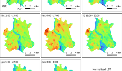
Séries Temporelles

Time series of satellite images: news, tools, applications

News

In English

Sentinel-2 reveals the surface deformation after the 2025 Myanmar earthquake

Sentinel-2 captured several clear-sky images of Myanmar before and after the 28 March 2025 earthquake. The animation below shows a 5-day apart sequence of images captured by Sentinel-2B and Sentinel-2C (10 m resolution) near the epicenter located close to Mandalay. The surface slip due to the earthquake follows the Sagaing Fault, a major fault in […]

CESBIO

Satellite Stereoscopy for Water Resource Monitoring?

=> In arid or semi-arid regions, where irrigation is widespread, monitoring agricultural water resources is essential to anticipate shortages. These resources may come from large dams, small reservoirs, or groundwater aquifers. This is the case in the state of Telangana, in South India, where numerous large dams (shown in cyan blue in the figure below) […]

CO3D

La stéréoscopie par satellite pour le suivi des ressources en eau ?

=> Dans les régions arides ou semi-arides, où l’irrigation est généralisée, le suivi de la ressource en eau agricole est primordial pour anticiper les pénuries. Cette ressource peut-être l’eau de grands barrages, de petits réservoirs ou provenant de l’aquifère. C’est le cas de l’état du Télangana, en Inde du Sud, où de nombreux grands barrages […]

Landsat

Evolution de l’altitude de la ligne de neige au cours des 41 dernières années dans le bassin versant du Vénéon (Oisans)

Pour contribuer à caractériser les conditions hydrométéorologiques lors de la crue torrentielle qui a frappé la Bérarde en juin, j’ai analysé une nouvelle série de cartes d’enneigement qui couvre la période 1984-2024 [1]. Grâce à la profondeur temporelle de cette série, on constate que l’altitude de la ligne de neige dans le bassin versant du […]

Datascience

Biophysical parameter retrieval from Sentinel-2 images using physics-driven deep learning for PROSAIL inversion

The results presented here are based on published work: Y. Zérah, S. Valero, and J. Inglada. « Physics-constrained deep learning for biophysical parameter retrieval from sentinel-2 images: Inversion of the prosail model« , in Remote Sensing of Environment, doi: 10.1016/j.rse.2024.114309. This work is part of the PhD of Yoël Zérah, supervised by Jordi Inglada and Silvia Valero. […]

Landsat

Is Antarctica greening?

In a recent study, Roland and Bartlett et al. (2024) showed that the Antarctic Peninsula is « greening », i.e. the area covered by vegetation is growing. This article published in Nature Geoscience was featured in many media outlets. The authors drew this conclusion from the analysis of 35 years of Landsat images. More specifically, they computed […]

aerosols agriculture Antarctica Aru Atmospheric correction biomasse Clouds CNES corrections atmosphériques cultures irriguées English ESA flood Forêt GEE glacier hazard Land Cover MACCS MODIS MUSCATE neige nuages Occupation des sols orbit orbite pléiades Products Produits Pyrénées Python Relevés de terrain SEN2COR Sentinel-2 site sites snow SPOT4(Take5) SudMipy Séries temporelles THEIA Time Series vegetation Volcano évapo-transpiration

Rechercher