Feedback on hydrological monitoring of Telangana region in India using remote sensing
Claire Pascal, PhD student at CESBIO, under the supervision of Olivier Merlin (CNRS researcher) and Sylvain Ferrant (IRD researcher) brilliantly defended her thesis on the monitoring of water resources by satellite on November 18.
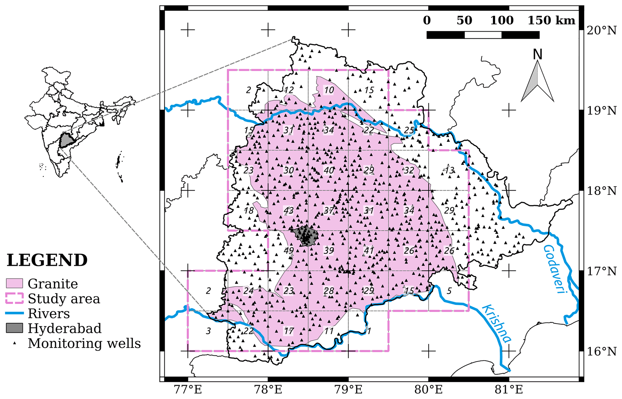
Claire’s work focused on the Telangana region of India where rainfed cotton and flooded rice farming dominate. The region has a wet season, during which 4 months of intense monsoon rains recharge aquifers and dam lakes and feed the large Godavari and Krishna rivers. It is followed by a long dry season of 8 months during which the drying of the soils requires to irrigate the crops with these water resources. Three quarters of the irrigation volumes are pumped from groundwater, and one quarter from surface reservoirs (100 large dams, over 40,000 small hillside reservoirs). Claire studied the feasibility of monitoring these resources with current and future satellite data.
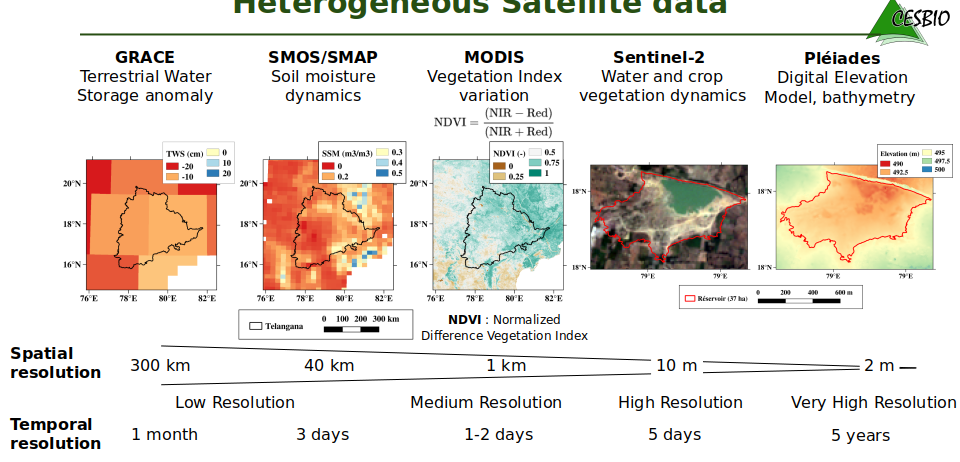
Gravimetric satellites (GRACE and GRACE-FO) provide access to water mass variations at a low resolution (300km): surface water, soil moisture and groundwater. Passive microwave satellites (such as SMOS and SMAP) allow us to reconstruct soil moisture variations at an intermediate spatial resolution (25 to 40 km). Multi-spectral optical satellites (MODIS and Sentinel-2 ) allow the monitoring of crops and vegetation development at medium and high spatial resolution (MRS, HRS, 1km to 10m). Stereoscopic satellites (Pléiades) at very high resolution (THRS, 50cm) allow the restitution of the bathymetry of hundreds of small hillside reservoirs, whose cumulative regional capacity is unknown until now. The environmental variables estimated by these satellite missions constitute heterogeneous data sources that are used here to explore our ability to:
- Disaggregate the low resolution gravimetric signal with the variables obtained at higher resolution, ( see figure GRACE_method)
- Explore the contribution of newer very high resolutions for monitoring water resources in small capacity hydrological structures.

- Assess existing methods for quantifying rice irrigation using SMOS soil moisture observations and Sentinel-2 rice maps.
The conclusions regarding space observation are as follows:
- SMOS can estimate the volume of water in the root zone by combining data and models (this is not a result of the PhD, it was known before)
- The set of hillside reservoirs form a cascade of ungauged retention reservoirs for monsoon runoff, maintained by local populations. Their size is too small for current altimetry data (Jason) but also for future SWOT data. The PhD evaluated their maximum capacity at about 30 mm thanks to bathymetry from Pleiades stereoscopy in low water period (empty reservoirs). This maximum capacity may seem limited compared to those of the large dams in this state (over 200mm of cumulative maximum capacity) but the contribution of these small structures, located in these areas upstream of large rivers and dams, is crucial for the surrounding irrigated agriculture. Claire showed that a regional monitoring of water volumes of this set of small reservoirs is possible using THRS data, acquired when the basins are empty, combined with the detection of water surfaces with Sentinel2. Pleiades does not have sufficient imaging capacity to extend this method to the whole of India, but it will be possible with the future CO3D mission, provided that the numerical models are obtained when the reservoirs are empty (some revisiting will be necessary). The Sentinel-HR mission could also meet these new needs with more revisit but less accuracy.

- The GRACE mission provides monthly variations of land water stocks with a resolution (~300km) equivalent to the dimensions of the study area. This data needs to be spatially deconvolved and disaggregated in order to estimate the variations of each hydrological compartment (especially the groundwater stock) in interaction with land use and irrigation practices. The PhD focused on the evaluation of already used disaggregation methods (15 publications worldwide) in order to propose a more realistic method of disaggregation validation. The different approaches using soil moisture from SMOS, NDVI from MODIS, rainfall from TRMM, evaluated with a piezometric dataset provided by the state of Telangana and the Franco-Indian Groundwater Research Cell in Hyderabad, generally improve the spatial representativeness of the GRACE data. However, the uncertainty on the groundwater stock derived from the disaggregated GRACE data remains relatively high. Indeed, the recharge and capture fluxes of the water table are indirectly linked to the variables available by remote sensing, which explains the difficulty of obtaining a predictive model from these observables alone. An improvement in the quality of the gravity signal and its resolution, as imagined by future gravity missions (MAGIC), is therefore desirable.

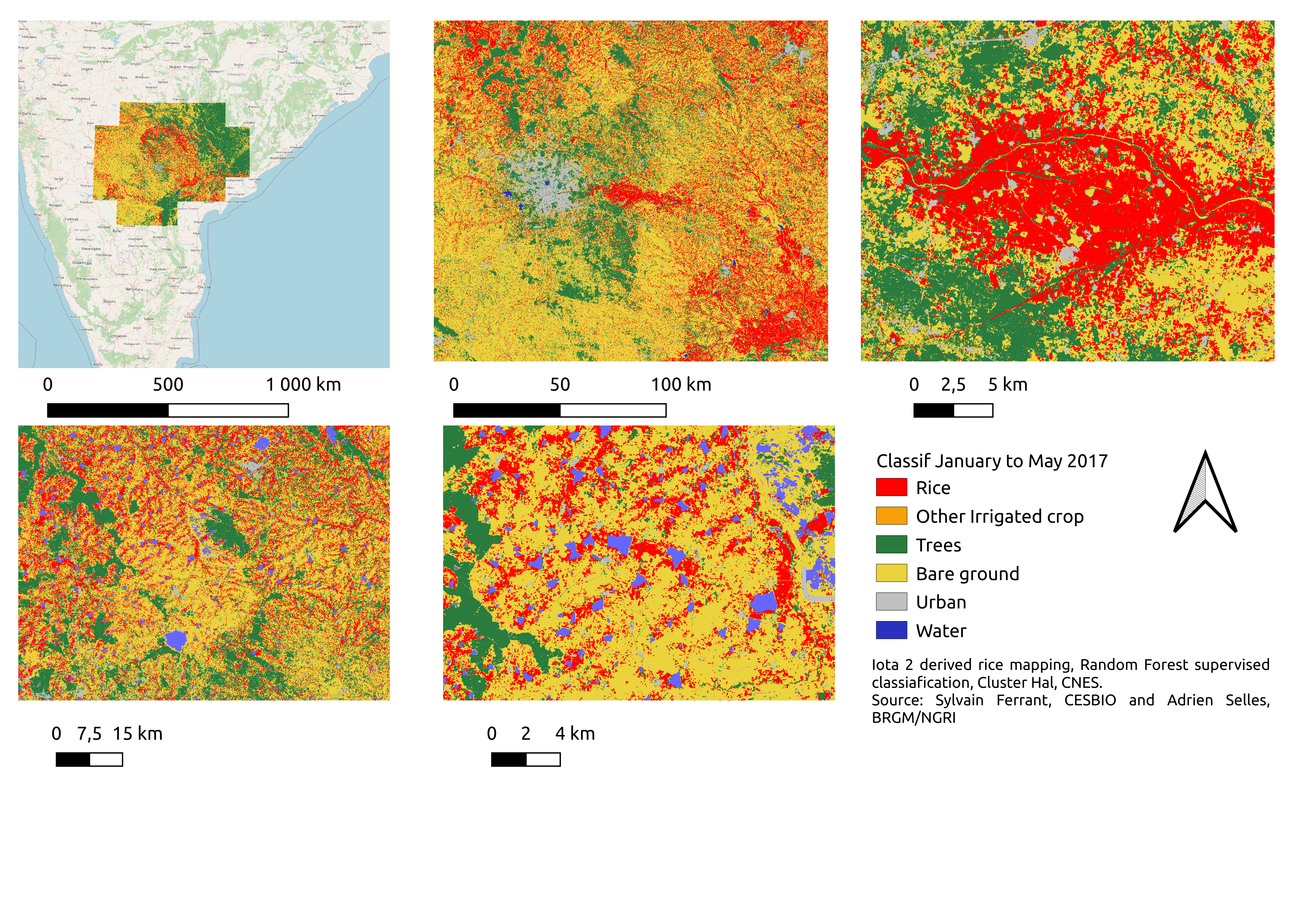
- In a final exploratory study, Claire investigated the presence in some highly irrigated areas of a significant dry season soil moisture « bounce » in the SMOS product (this bounce is less present in the SMAP products). She linked the magnitude of this soil moisture signal to the extent of rice cultivation on each of the SMOS maps (25km). These seasonal rice areas are estimated at high resolution (10m) using the land cover map production chain (IOTA2) deployed on the CNES HAL cluster, from Sentinel-2 surface reflectances (L2A products produced by THEIA) for the 8 rice growing seasons between 2016 and 2019, at the Telangana state scale. These relationships are preliminary results that could be used to build a regional quantitative model of water resources mobilized for rice irrigation. An upgrade of SMOS resolution to 10 km, as proposed by the SMOS-HR mission, should improve the models found. An internship is planned in 2023 to address this issue.
