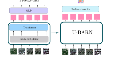
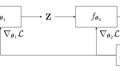
Land cover – Occ.des sols

Training deep neural networks for Satellite Image Time Series with no labeled data

The results presented in this blog are based on the published work : I.Dumeur, S.Valero, J.Inglada « Self-supervised spatio-temporal representation learning of Satellite Image Time Series »  in IEEE Journal of Selected Topics in Applied Earth Observations and Remote Sensing, doi: 10.1109/JSTARS.2024.3358066. In this paper, we describe a self-supervised learning method to train a deep neural network […]

17.04.2024

SapienSapienS et le CNES nous expliquent l’observation de la terre

Le CNES a confié à la société SapienSapienS la réalisation de belles vidéos pour le grand public, qui expliquent de manière très didactique, et en moins de 5 minutes, différentes thématiques d’observation de la terre. Trois d’entre-elles font la part belle aux travaux du CESBIO, et je suis très fier d’avoir contribué à la première […]

28.02.2024

End-to-end learning for land cover classification using irregular and unaligned satellite image time series

The results presented here are based on published work : V. Bellet, M. Fauvel, J. Inglada and J. Michel, « End-to-end Learning For Land Cover Classification Using Irregular And Unaligned SITS By Combining Attention-Based Interpolation With Sparse Variational Gaussian Processes, » in IEEE Journal of Selected Topics in Applied Earth Observations and Remote Sensing, doi: 10.1109/JSTARS.2023.3343921. This […]

19.01.2024

A new operational method for monitoring oak dieback in the Centre-Val de Loire region

=>  The results presented here are based on work published in the journal paper: F. Mouret, D. Morin, H. Martin, M. Planells and C. Vincent-Barbaroux, « Toward an Operational Monitoring of Oak Dieback With Multispectral Satellite Time Series: A Case Study in Centre-Val De Loire Region of France, » in IEEE Journal of Selected Topics in Applied […]

22.11.2023

A 10 m resolution land cover map of Sahel with iota2

iota2 is the large scale mapping software developed at CESBIO. iota2 takes high resolution satellite image time series (SITS), usually Sentinel (1 and 2) or Landsat, and produces maps over large areas. Maps of most usual variables of interest in remote sensing can be produced, since iota2 can compute user-defined functions at the pixel level, […]

09.01.2023

Feedback on hydrological monitoring of Telangana region in India using remote sensing

=> Claire Pascal, PhD student at CESBIO, under the supervision of Olivier Merlin (CNRS researcher) and Sylvain Ferrant (IRD researcher) brilliantly defended her thesis on the monitoring of water resources by satellite on November 18. Claire’s work focused on the Telangana region of India where rainfed cotton and flooded rice farming dominate. The region has […]

01.12.2022

Retour d’expérience sur le suivi hydrologique d’une région Indienne par télédétection

=> Claire Pascal, doctorante au CESBIO, sous la direction d’Olivier Merlin (chercheur CNRS) et co-dirigée par Sylvain Ferrant (chercheur IRD) a brillamment soutenu sa thèse sur le suivi des ressources en eau par satellite le 18 novembre. Les travaux de Claire se sont focalisés sur la région du Telangana en Inde où la culture non […]

10.11.2022

Le Mask R-CNN pour la délinéation de parcelles : retour d’expérience

=> Les techniques de l’état de l’art en Deep Learning permettent-elles une délinéation individuelle de chaque parcelle de culture, comme le laisse penser cet article récent ? C’est ce que nous avons cherché à savoir au cours d’un stage au CESBIO en cherchant à qualifier l’architecture Mask R-CNN pour cette tâche. Nous vous livrons ici […]

24.09.2021

Feedback on Mask R-CNN for croplands delineation

=> Do state-of-the-art deep learning techniques allow for individual delineation of each cropland, as suggested by this recent article? In the context of an internship at CESBIO, we tried to evaluate the performance of Mask R-CNN architecture for this task. In this post, we summarize what we learned. Mask R-CNN principles To sum up, Mask […]

Rechercher