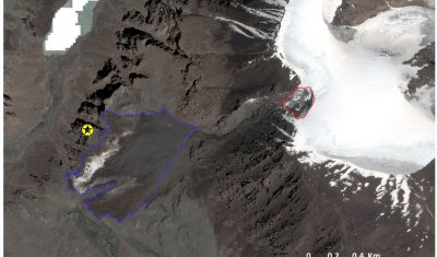
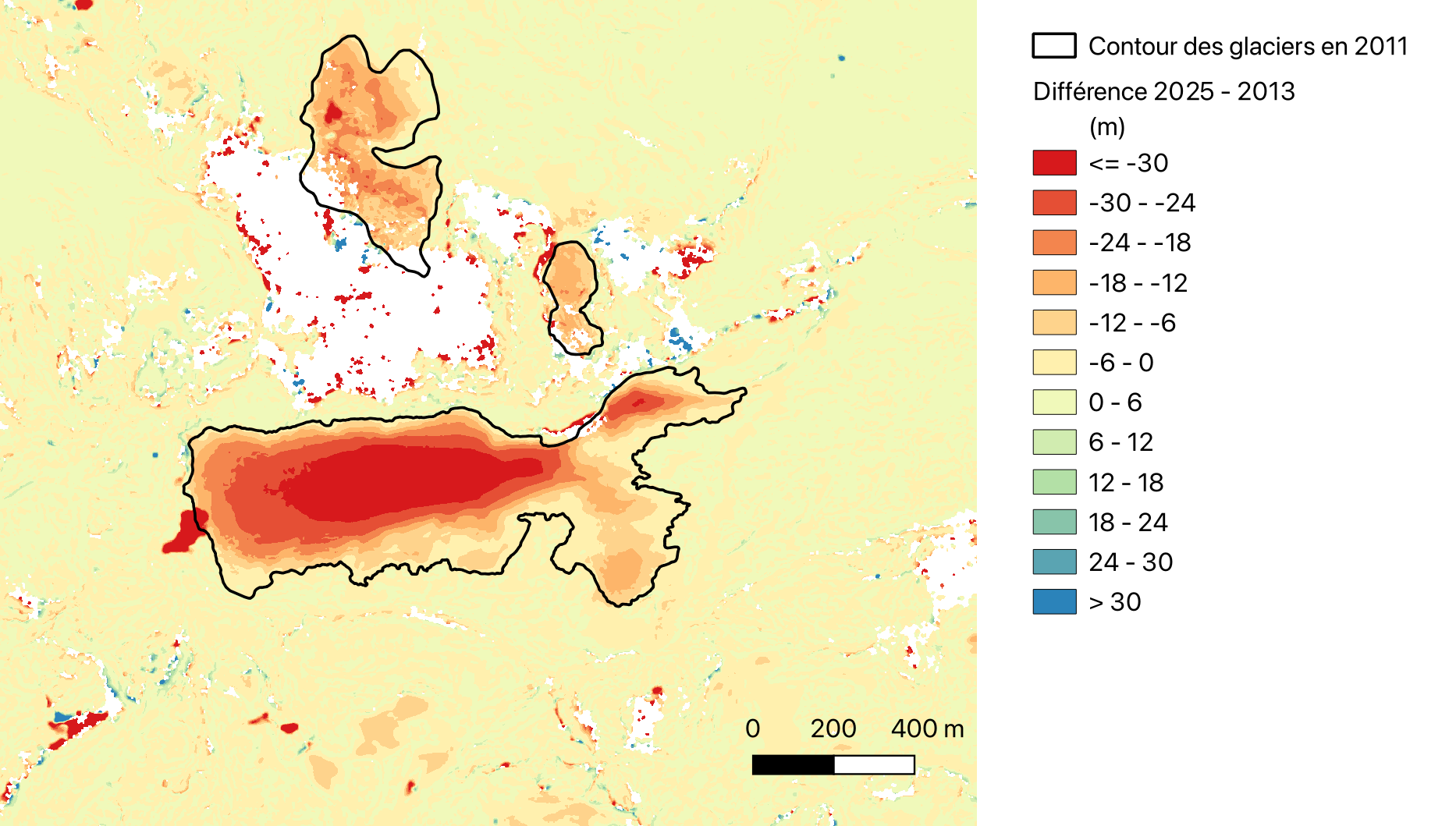
3D

Premiers MNT LiDAR HD

L’IGN communique actuellement sur la mise à disposition des premiers MNT dérivés des nuages de points LiDAR HD. A mon avis, cet exemple est mal choisi puisqu’un MNT de la citadelle de Gravelines de qualité équivalente  était déjà disponible dans le RGE ALTI® 1m en libre accès depuis le 1er janvier 2021. Sur ce secteur […]

14.07.2024

Glacier changes in the Lingtren–Khumbutse catchment using Pléiades

The iconic Khumbu Glacier in Nepal is fed by several tributaries, such as this branch in the Lingtren–Khumbutse catchment. Recently a new Pléiades triplet covering the Khumbu region was added into the DINAMIS repository (acquisition date 22 Oct 2023). There is another triplet in the same area acquired on 11 Mar 2016 hence we can […]

13.11.2023

Découvrir les structures cachées du paysage grâce au lidar

Le lidar est magique ! Cette technologie permet de mesurer très précisément l’altitude du sol y compris sous la végétation. Voici un exemple qui montre des sentiers cachés dans une forêt du Jura :   L’image en teintes de gris est un « hillshade » c’est-à-dire un ombrage du relief. Ce relief est issu du RGE ALTI […]

28.05.2023

Artificial snow accumulation detected from space

People often ask if we can detect artificial snow in satellite images. It’s not so easy except when the surrounding slopes are totally snow-free… But recently, I noticed some anomalous snow accumulations patterns in a satellite-derived map of the snow depth near Super Barèges ski resort (Pyrenees). This map was computed at 2 m resolution […]

03.04.2023

Feedback on hydrological monitoring of Telangana region in India using remote sensing

=> Claire Pascal, PhD student at CESBIO, under the supervision of Olivier Merlin (CNRS researcher) and Sylvain Ferrant (IRD researcher) brilliantly defended her thesis on the monitoring of water resources by satellite on November 18. Claire’s work focused on the Telangana region of India where rainfed cotton and flooded rice farming dominate. The region has […]

01.12.2022

Retour d’expérience sur le suivi hydrologique d’une région Indienne par télédétection

=> Claire Pascal, doctorante au CESBIO, sous la direction d’Olivier Merlin (chercheur CNRS) et co-dirigée par Sylvain Ferrant (chercheur IRD) a brillamment soutenu sa thèse sur le suivi des ressources en eau par satellite le 18 novembre. Les travaux de Claire se sont focalisés sur la région du Telangana en Inde où la culture non […]

10.11.2022

Kyrgyzstan glacier collapse. New Pléiades and SPOT7 images tell us more…

Because the first images were partly cloudy, the Pléiades 1A and 1B satellites (CNES/Airbus) continued to acquire images over Kyrgyzstan and a cloud-free 0.7-m stereoscopic pair was acquired 16 July 2022. We could also obtain a 1.5 m SPOT7 stereoscopic pair from the Airbus DS archive thanks to the Dinamis initiative. The latter was taken […]

22.07.2022

Kyrgyzstan viral avalanche. First views of the glacier scar using Pléiades images

Last week, Simon Gascoin and I spent quite some time working on the Marmolada event. Just a week-end to rest and Twitter reminded us Monday morning that this summer 2022 was special for glaciers. Not only are they out of balance with the climate and will probably suffer one of their most negative mass balance […]

12.07.2022

Estimation of Marmolada glacier collapse volume using Pléiades imagery

The deadly Marmolada glacier collapse happened on 3 July 2022. On 6 July 2022, Pléiades 1B (CNES, Airbus DS)  acquired a clear-sky stereo pair of the area. From these images we could estimate a detached volume of ice of 65’000 ± 10’000 cubic meters. First, we generated a digital elevation model (DEM) from Pléiades stereo […]

07.07.2022

Rechercher