The missing link to valorize CESBIO’s applicative research works
My colleagues at CESBIO are extremely creative! Over the past ten years, they have developed a wide range of new products and methods for extracting information from Copernicus data. They don’t just develop and validate the method on a few sites; they continue their work until they have produced data for the whole of France.
The advantage of producing data for the whole of France is that it demonstrates the robustness of the approach and the pre-operational state of the chain, while reaching a large number of users. However, producing data for the whole of France requires considerable computing power and storage capacity, not to mention the time needed to monitor production. This kind of effort is generally not expected of researchers.
Fortunately, we have the support of the CNES computing centre, which provides us with computing power, all Sentinel-1 and Sentinel-2 data, and S2A level 2A products processed with MAJA across Europe and other areas.
This article presents several examples of production of enviromental variables on a France-wide scale, concluding with an examination of how to capitalise on this research and address its missing link.
Yearly land cover
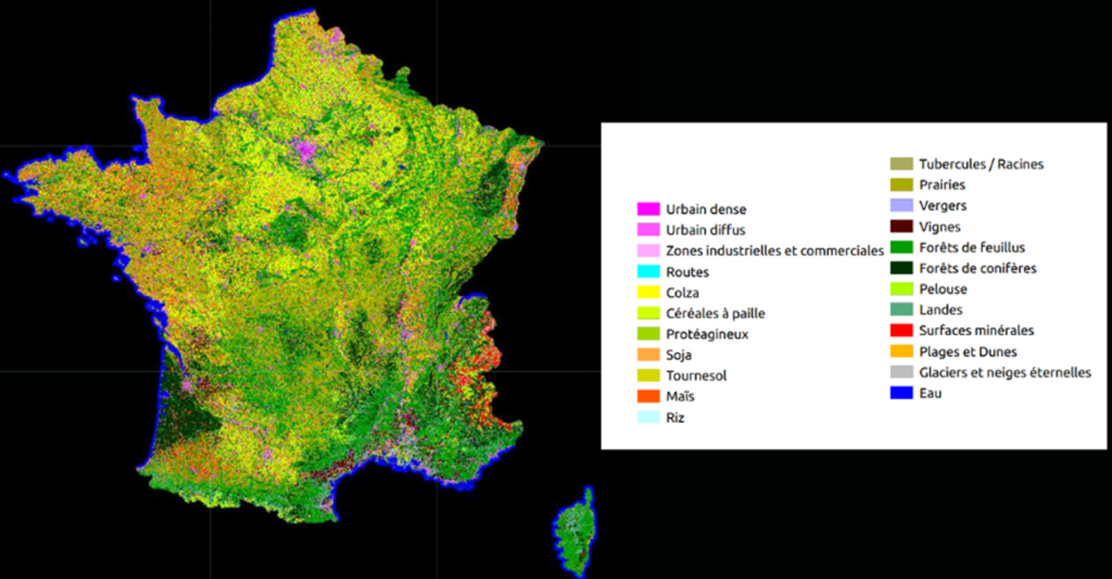
The first thematic product that CESBIO worked on in 2014 was the Land Cover Map (OSO), which was produced using a machine learning method and Copernicus data. Featuring 23 different classes, including numerous agricultural classes, it is produced annually and provided in raster and vector versions with a resolution of 20 m. The production process uses just over a year’s worth of Sentinel-2 data as input. OSO was produced at CESBIO in 2017 with funding from TOSCA (CNES) and ESA. Its operation was then entrusted to the THEIA team at CNES and it has been provided annually ever since. OSO is widely used in France, particularly for agriculture and grasslands, but nevertheless has an error rate of over 10%. CESBIO is studying an improvement based on deep learning, with the aim of providing this map three times a year.
Ref: Inglada, J., Vincent, A., Arias, M., Tardy, B., Morin, D., & Rodes, I. (2017). Operational high resolution land cover map production at the country scale using satellite image time series. Remote Sensing, 9(1), 95, https://www.mdpi.com/2072-4292/9/1/95
Snow cover extent
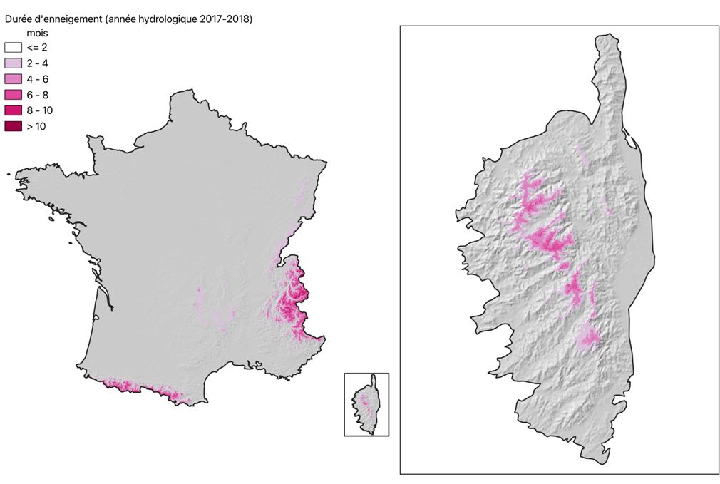
It is also one of the first thematic products to be developed by CESBIO, and CNES has decided to operate it for THEIA. The method is based on multispectral thresholds applied to Sentinel-2 images, and it achieves 3% accuracy in identifying snow cover. These data can be used to predict the water content of snow, even when its thickness is unknown, and to study biodiversity. They are also useful for tourism. It was selected by the Copernicus Land Monitoring Service for production on a European scale and its operation was transferred to Magellium. However, its operation continues at CNES, enabling improvements and new versions to be tested.
ref: Gascoin, S., Grizonnet, M., Bouchet, M., Salgues, G., and Hagolle, O.: Theia Snow collection: high-resolution operational snow cover maps from Sentinel-2 and Landsat-8 data, Earth Syst. Sci. Data, 11, 493–514, https://doi.org/10.5194/essd-11-493-2019, 2019.
Meadows first mowing dates
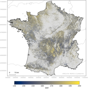
This product was developed at CESBIO in collaboration with the French Biodiversity Agency (OFB). It uses Sentinel-2 data and a machine learning method based on in situ data collection. Its uncertainty of just 6 days is an excellent performance for a satellite that passes every 5 days and is sensitive to clouds. This product is an important variable for biodiversity as postponing the date of the initial mowing is crucial for the development of seeds. This map was produced for 2022, but we have not yet found a way to make this process sustainable, so it may be discontinued..
Réf : Henry Rivas, Hélène Touchais, Vincent Thierion, Jerome Millet, Laurence Curtet, Mathieu Fauvel, Nationwide operational mapping of grassland first mowing dates combining machine learning and Sentinel-2 time series, Remote Sensing of Environment, Volume 315, 2024, ttps://doi.org/10.1016/j.rse.2024.114476
A posteriori agriculture yield
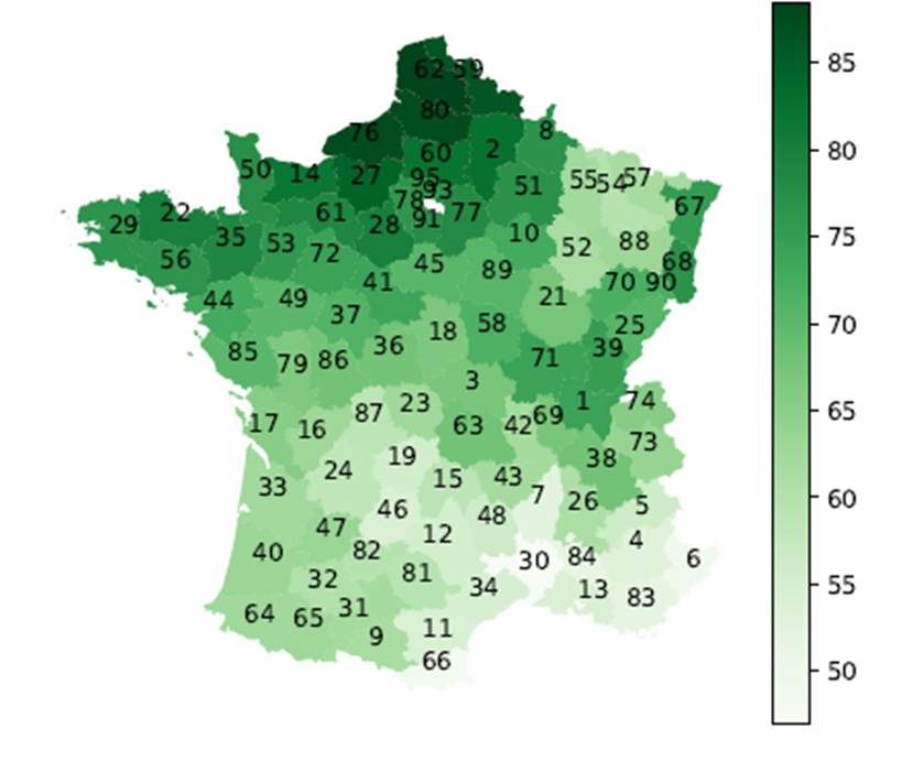
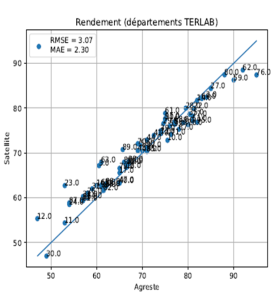
This product is also based on a machine learning method, using a collection of information from farmers as input. The need for this information means that the product cannot be provided in real time. It is validated by comparison with the Agreste database aggregated by department, and its accuracy at the parcel level is around 10%, and better than 5% at the department level. This method is being transferred to the agricultural production statistics department of the Ministry of Agriculture via the CNES Earth Observation Laboratory. It has since been extended to other major crops. However, its annual production has not yet been decided.
Ref: not published as a peer review article but a report is available : https://hal.science/hal-02935469v1
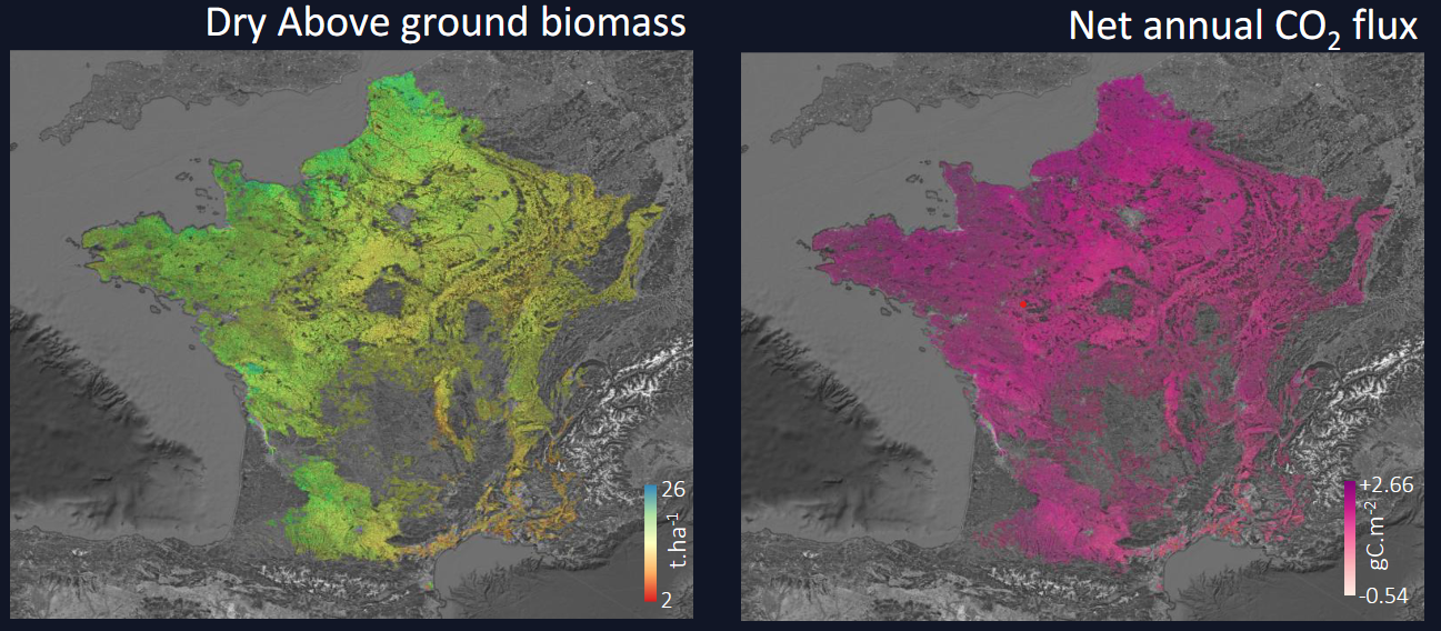
Crop biomass and CO2 flux
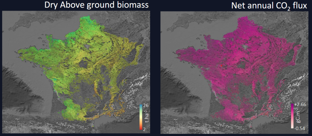
This product, obtained using the ACEO pipeline, allows the biomass of field crops to be calculated by modelling their annual growth using all Sentinel-2 data from that season. The pipeline can also be used to estimate CO2 fluxes towards the ground. The biomass accuracy is 10%. This product could be used in real time, provided the type of crop grown in the studied plots is known. At the national level, production occurs the following year. An initiative is underway to transfer the technology to several companies (Natais, Netcarbon and MyEasyFarm), targeting the market for incentives for good agricultural practices. However, producing these variables at the national level would be very useful for regional or national assessments. Currently, there is no funding for this production. Production has been proposed to THEIA in 2021, but no decision has yet been made.
ref: Wijmer, T., Al Bitar, A., Arnaud, L., Fieuzal, R., & Ceschia, E. (2024). AgriCarbon-EO v1. 0.1: large-scale and high-resolution simulation of carbon fluxes by assimilation of Sentinel-2 and Landsat-8 reflectances using a Bayesian approach. Geoscientific Model Development, 17(3), 997-1021. https://gmd.copernicus.org/articles/17/997/2024/
Irrigation detection

The method developed by CESBIO in collaboration with MEOSS makes it possible to identify irrigated agricultural plots each year. It is a machine learning method that uses one year of Sentinel-1 and Sentinel-2 data as well as meteorological data on precipitation. This product is being promoted by MEOSS through a France 2030 project with the Ministry of Agriculture as its anchor customer, which could, at the end of the project and if it so decides, support production on a national scale. MEOSS is also using the product internationally. To formalize the collaboration on that subject, MEOSS and CESBIO have created a joint laboratory.
ref: Amin, G., Oberlin, T., Vigouroux, J., Chambre, G., Dejoux, J.-F., Le Page, M., Merlin, O., Hagolle, O.,Demarez, V. Country-Scale Irrigation Mapping in France Using SAR and Optical Time Series with Deep Learning. (In preparation)
Hauteur des forêts et biomasse
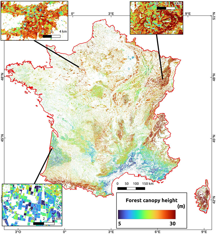
This product provides tree height data that can be used to estimate biomass. It was developed using a machine learning method with Sentinel-1, Sentinel-2 and ALOS data, and GEDI Lidar data was used as a reference. The height uncertainty is 3.7 metres, and the biomass uncertainty is 75 tonnes per hectare. This product is useful for determining carbon storage at all levels, from local to national, and for studying its evolution and assessing the effects of storms, droughts or pest attacks (insects or bulldozers 😉 ). Production has been proposed to THEIA in 2022, but no decision has yet been made.. A new version is currently being developed using research budgets, using airborne HD LiDAR data available in France.
Ref 1: Morin, D.; Planells, M.; Guyon, D.; Villard, L.; Mermoz, S.; Bouvet, A.; Thevenon, H.; Dejoux, J.-F.; Le Toan, T.; Dedieu, G. Estimation and Mapping of Forest Structure Parameters from Open Access Satellite Images: Development of a Generic Method with a Study Case on Coniferous Plantation. Remote Sens. 2019, 11, 1275. https://doi.org/10.3390/rs11111275
Ref 2 : Kalinicheva, Ekaterina and Helen, Florian and Mermoz, Stéphane and Mouret, Florian and Planells, Milena, Super-Resolved Canopy Height Mapping from Sentinel-2 Time Series Using LiDAR HD Reference Data across Metropolitan France (submitted)
Forest cuts in France
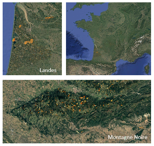
This product is the result of a collaboration between Globeo and CNES. It provides forest cutting date information every 15 days at a resolution of 10 metres, with an accuracy of around 95%. This is slightly better for conifers (96%) than for deciduous trees (94%). This method uses Sentinel-1 data and is an adaptation of theTropiSCO product for temperate forests. This research was funded by ADEME. Data were processed from 2018 to 2025 and are available here. Funded by research projects, improvements are underway to distinguish between dieback and logging. However, the public dissemination of this data is not funded and may therefore have to be discontinued.
Ref: S. Mermoz, J. Doblas, M. Planells et al., « Submonthly Assessment of Temperate Forest Clear-Cuts in Mainland France, » in IEEE Journal of Selected Topics in Applied Earth Observations and Remote Sensing, vol. 17, pp. 13743-13764, 2024, https://ieeexplore.ieee.org/abstract/document/10604724
The Missing Link
The examples above demonstrate the creativity of CESBIO researchers and their commitment to developing methods that can be applied on a national or continental scale. They also show what an excellent tool the Copernicus program is for monitoring our environment. However, the lessons learned from the eight examples above shows that it is very difficult to move on to sustainable production of these data (production over several years). All of the projects have received various forms of funding for research, demonstration, and service improvement, but only two of these products (OSO and snow cover) are being produced on a long-term
These examples come from a single laboratory, and I have not presented everything; some of pour methods have not been produced yet on a national scale, even though they have demonstrated their quality. And fortunately, CESBIO is not the only French laboratory in this field, and other similar products exist in other labs.
It seems to me that one of the reasons for the transfer difficulties is a missing link in the French funding system. At present, we have access to three funding systems, and a fourth is missing:
- Research and development funding helps improve the technical readiness level (TRL) of the product. Examples include thesis grants, CNES TOSCA budgets, calls for proposals from the French National Research Agency, Horizon Europe, and ESA funding.
- Funding for service maturation (SRL) exists and has increased in recent years. In France, we have the Space for Climate Observatory, France2030, BASS at ESA, etc. However, this funding is often based on the hope that the data will be commercially exploited. The aim is therefore to fund research and maturation, in the hope that exploitation will be self-financing through commercial revenue. However, I think it is unlikely that all the products mentioned above will generate significant commercial revenue.
- Public funding for the exploitation of space data exists at the European level. These include Copernicus products and the ESA Climate Change Initiative (ESA-CCI). However, only the former is interested in decametric resolution.
Few products are yet managed in the CLMS, and they are costly to set up because they are produced on a European scale. Consequently, there is a certain aversion to risk in such projects and obtaining approval to launch a new product is very complex. It is necessary to convince stakeholders of the need for funding, ensure that the product will be used and confirm that it is sufficiently robust and of high quality. If you haven’t yet demonstrated that your product is already good and interests users, there is little chance it is selected. This is for instance how the snow cover extent from CESBIO was selected.
In my opinion, the missing link is regional or national funding for production chains for environmental variables, which are unlikely to be commercially viable. France has the infrastructure to do this with the THEIA cluster or the National mapping agency (IGN). However, funding is lacking, and the THEIA centre has not commissioned any new chains covering the whole of France since 2019. Our discussions with the ministries of environment or agriculture indicate a need for territorial knowledge and the relevance of spatial data, particularly Copernicus, and of some of our methods. To my knowledge, the only thing lacking is a funding system (and if i’m wrong, please tell me, that would be good news).
This absence is a waste of resources in France. The Copernicus system, to which France contributes a lot of money, is underused for improving knowledge of the territory, and excellent research work is lost in the valorisation system.
Are there better funding systems for remote sensing applications to monitor the environment, elsewhere in Europe?