Satellite Missions

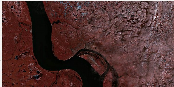
Sentinel-2A (and Landsat-8) capture a giant ice avalanche in Tibet

After reading my previous post about the Rutog ice avalanche, my distinguished colleagues Antoine R. and Olivier H. challenged me to look for a pre-event image to better highlight the avalanche area. The closest clear-sky image that I could find is a Landsat-8 image that was acquired on June 24 (23 days before the slide).

25.08.2016

Sentinel-2A captures a giant ice avalanche in Tibet

The Nature News website reported yesterday on a massive ice avalanche that happened in Rutog, Tibet, on 17 July 2016. This ice avalanche killed 9 people and may be one the largest ever observed. The ice and rock mixture spread over 6 km from the collapse point up to the Aru Co lake shoreline.

Les séries temporelles de Sentinel-2 sont bien lisses !

=> Dans un précédent billet, j’ai montré un exemple de série temporelle obtenu sur un pixel de forêt de pins, qui met en valeur la bonne qualité des séries temporelles que l’on obtient avec les données Sentinel-2, traitées au niveau 2A par THEIA en utilisant la chaîne MACCS. (les données de niveau 2A sont corrigées […]

22.08.2016

TOMCAR-Sat : Remote Sensing on the Yenisei river!

Since October 2015, the TOMCAR-Sat project aims to use high resolution satellite products to monitor Dissolved Organic Carbon (DOC) fluxes on the Arctic river Yenisei. Specifically, its objectives consist to calibrate a DOC retrieval model from time-series of satellite images and to characterize dynamics of the factors that may affect DOC concentrations, i.e. the snow […]

19.08.2016

Sentinel-2 time series are smooth !

=>  In a previous post, I showed a time series of pixels showing the good data quality of time series we get with Sentinel-2, processed to Level 2A by THEIA using MACCS  processor. However, I concluded that the plot I showed still had some low noise, and that a part of it was due to […]

18.08.2016

Snow and Fire in the Dragon mountains

NASA’s blog « Image of the Day » recently featured two beautiful MODIS images of the snow cover in Lesotho. In late July Lesotho experienced its heaviest snowfall in two decades. The snow is not uncommon in Lesotho given that over 80% of the country lies above 1800 m. However the frequency of such snow events has […]

16.08.2016

Sentinel-2 MACCS L2A reflectance stability

As MACCS was used to produce a large amount of images (all the images acquired over France), we were able to make some more validation tests, such as checking the surface reflectance stability. To do that, the region of Arles in Provence (France), tile 31TFJ, is a good site, with a lot of clear skies, […]

05.08.2016

Some summer news about Sentinel-2 and THEIA’s level 2A production

=>  Theia – MUSCATE I had a week of work in the middle of my holidays, which enabled be to see how the work on Sentinel-2  L2A data distribution is progressing. My colleagues who worked all July (Dominique, Joelle, Céline…) did a great job : they were able to process a large data set of […]

04.08.2016

Quelques nouvelles estivales de Sentinel-2 et des productions de N2A par Theia

=> Theia – MUSCATE J’ai pris une petite semaine de travail au milieu de mes vacances, ce qui m’a permis de suivre un peu l’avancement des travaux sur Sentinel-2. Mes collègues aoûtiens (Dominique, Joelle, Céline…) ont bien travaillé en juillet : ils ont pu lancer une production de masse avec MUSCATE. Ils ont traité toutes […]

Rechercher