Satellite Missions

Land-cover map around Shepparton

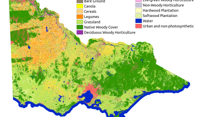
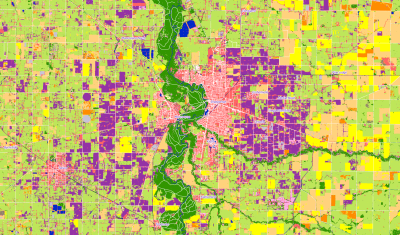
Cartographier l’occupation des sols d’une partie de l’Australie à 10 m de résolution

(English version here) Peu de pays sont plus éloignés de la France que l’Australie. La carte d’occupation des sols dont nous parlons aujourd’hui concerne l’État du Victoria au Sud-Est de l’Australie. Cet État est quasiment diamétralement opposé à la Turquie avec des latitudes autour de 37°S et des longitudes autour de 145°E. Nous avons reproduit […]

26.09.2019

Land cover map of Victoria, Australia

Mapping (a part of) Australia at 10 m resolution

(French version here) It would be difficult to be farther away from France than Australia. In fact, the map we’re talking about today is of the State of Victoria in Australia, which is roughly diametrically opposed to Turkey with latitudes around  37°S and longitudes around 145°E. What we have done is reproduce the methodology that […]

24.09.2019

The DLR starts distributing Sentinel-2 L2A products produced with MAJA over Germany

A good news for German users of Sentinel-2 data !   You might have already read on this blog that the German Aerospace Center, DLR became a member of MAJA development team in 2016. For instance, they provided the nice cirrus correction method. One of the team objectives was also to implement MAJA within DLR’s […]

23.09.2019

India water crisis: Sentinel-1 detects surface water, ForEarth app restitutes and shares water stresses

In the framework of an open call Science4society funded by ESA, researchers at CESBIO have implemented a surface water detection algorithm from radar data Sentinel-1 on a cloud computing system. An API developed by Geomatys and JeoBrowser, two Information Technologies companies in France, is used to send the resulting surface water masks to a smartphone […]

17.09.2019

Upgrade of let-it-snow to compute the fractional snow cover

In preparation for the next Pan European high resolution snow and ice monitoring service, I have upgraded the let-it-snow (LIS) processor to enable the computation of the fractional snow cover (FSC) within the pixel. So far LIS was only used to compute a « binary snow mask » (in fact ternary: snow, no-snow, cloud). However, the EEA […]

12.09.2019

Le traitement des données Sentinel-2 L2A au Sahel progresse

=> Comme nous l’avions annoncé en Novembre, le centre de production MUSCATE de Theia rajoute progressivement des zones au Sahel, qui sont affichées sur l’image ci-dessous. Les données sont traitées à partir de décembre 2016, ce qui nous fait une grande quantité de données à traiter. Nous avons donc commencé avec les tuiles les plus […]

10.09.2019

THEIA’s Sentinel-2 L2A processing on Sahel is progressing

=> As we had announced in November, the MUSCATE production centre in Theia is gradually adding areas in the Sahel, which are shown in the image below. The data are processed from December 2016 onwards, which means that we have a large amount of data to process. We started with the most westerly tiles, in […]

[Comment ça marche] Les réflectances peuvent-elles être supérieures à un ?

Attention, ce document contient des équations => A force d’écrire des articles sur ce blog, ou sur les réseaux sociaux, ou parce que je publie des codes sur github,  je reçois de nombreuses questions, auxquelles j’essaie de répondre. Une partie d’entre elles porte sur les valeurs des réflectances, comme par exemple: Le fait que les […]

04.09.2019

[How it works] Can reflectances be greater than 1 ?

=>  Beware, this document contains equations Having written a lot of posts in this blog, twitter or linkedIn, or due to the distribution of products and softwares on Theia or Github, Users of these channels questions per week in one of these channels, which I try to answer, even if not always at once. Many […]

03.09.2019

Rechercher