In English

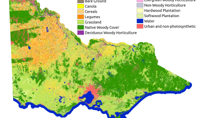
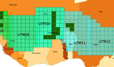
[New] Time series of Sentinel-2 monthly syntheses in Italy

=> As announced a few months ago, our monthly synthesis processor for Sentinel-2 data, WASP, has been integrated to THEIA’s land data center processing facility at CNES, in spring 2019. We are therefore now extending the zones where we process the monthly synthesis (the so-called Level-3A products). Here is how to look for Level 3A […]

22.10.2019

Khumbu icefall in 4D

This video shows all available Venµs images since launch over the Khumbu icefall near Mt Everest (109 images). The images are RGB composites of Level 1C bands 7,4,3 (5 m resolution) that were draped onto the HMA 8m DEM.   How to do that? First download the Venµs images using theia_download.py, extract the region of […]

13.10.2019

Land cover map of Victoria, Australia

Mapping (a part of) Australia at 10 m resolution

(French version here) It would be difficult to be farther away from France than Australia. In fact, the map we’re talking about today is of the State of Victoria in Australia, which is roughly diametrically opposed to Turkey with latitudes around  37°S and longitudes around 145°E. What we have done is reproduce the methodology that […]

24.09.2019

The DLR starts distributing Sentinel-2 L2A products produced with MAJA over Germany

A good news for German users of Sentinel-2 data !   You might have already read on this blog that the German Aerospace Center, DLR became a member of MAJA development team in 2016. For instance, they provided the nice cirrus correction method. One of the team objectives was also to implement MAJA within DLR’s […]

23.09.2019

India water crisis: Sentinel-1 detects surface water, ForEarth app restitutes and shares water stresses

In the framework of an open call Science4society funded by ESA, researchers at CESBIO have implemented a surface water detection algorithm from radar data Sentinel-1 on a cloud computing system. An API developed by Geomatys and JeoBrowser, two Information Technologies companies in France, is used to send the resulting surface water masks to a smartphone […]

17.09.2019

Upgrade of let-it-snow to compute the fractional snow cover

In preparation for the next Pan European high resolution snow and ice monitoring service, I have upgraded the let-it-snow (LIS) processor to enable the computation of the fractional snow cover (FSC) within the pixel. So far LIS was only used to compute a « binary snow mask » (in fact ternary: snow, no-snow, cloud). However, the EEA […]

12.09.2019

THEIA’s Sentinel-2 L2A processing on Sahel is progressing

=> As we had announced in November, the MUSCATE production centre in Theia is gradually adding areas in the Sahel, which are shown in the image below. The data are processed from December 2016 onwards, which means that we have a large amount of data to process. We started with the most westerly tiles, in […]

10.09.2019

[How it works] Can reflectances be greater than 1 ?

=>  Beware, this document contains equations Having written a lot of posts in this blog, twitter or linkedIn, or due to the distribution of products and softwares on Theia or Github, Users of these channels questions per week in one of these channels, which I try to answer, even if not always at once. Many […]

03.09.2019

VENµS monitors the resillience of Bouconne forest to caterpillar defoliation

=> I left you in mid-July with an unbearable suspense: would the Bouconne oak forest, the real lung of the Toulouse conurbation, resist the caterpillar attack of which it was the victim? The gypsy moth is a small butterfly whose voracious caterpillar appreciates oaks. This year, the moth caterpillars have flourished in some areas of […]

09.08.2019

Rechercher