Forest

TropiSCO scores against deforestation

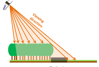
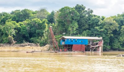
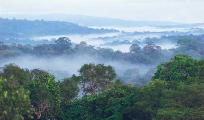
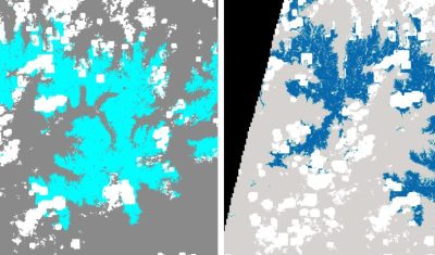
=> The TropiSCO project aims at providing maps of tree cover loss in dense tropical forests using Sentinel-1 satellite images, starting in 2018 and in near real time. The maps will soon be publicly available via a webGIS platform and updated weekly at 10m resolution. Forest loss as small as 0.1 hectare will be detected […]

05.02.2022

TropiSCO secoue la déforestation

=> L’objectif du projet TropiSCO est de fournir des cartes de suivi des pertes de couverture forestière dans les forêts denses tropicales avec les images des satellites Sentinel-1, à partir de 2018 et en continu. Les cartes seront bientôt accessibles publiquement via une plateforme webGIS et mises à jour toutes les semaines, à 10m de […]

TropiSCO : a project to monitor tropical deforestation with Sentinel-1 on a weekly basis

=> Do we need to remind you of all the collateral damage linked to deforestation or the eco-system services that forests provide ? We have already talked about these in this blog (here and there too). Yet forests are disappearing at an alarming rate. Between 1990 and 2020, an area of forest equal to more […]

20.02.2021

TropiSCO : un projet pour le suivi hebdomadaire de la déforestation tropicale avec Sentinel-1

=> On ne vous rappelle pas tous les dommages collatéraux liés à la déforestation ni les services éco-systémiques que nous rendent les forêts, puisqu’on en a déjà parlé dans ce blog (là, et là aussi). Pourtant, les forêts disparaissent à un rythme alarmant. Entre 1990 et 2020, une surface de forêt équivalente à plus de […]

18.02.2021

Orpaillage sur le fleuve frontalier entre la Guyane et le Suriname : télédétection des dommages causés par les barges aux rives du Maroni

Le Suriname, comme l’ensemble du plateau des Guyanes, est touché depuis plus de trente ans par le fléau de l’orpaillage qui entraîne la destruction du couvert forestier, la pollution des cours d’eau, en impactant fortement l’environnement et les population locales. L’orpaillage y est dit primaire quand l’or est directement extrait de la roche-mère, alors qu’il […]

09.09.2020

Benefits of SAR for forest loss alert detection in the tropics

The tropical forest is an important carbon sink which also hosts high biodiversity. Monitoring forest loss is therefore a major issue which requires efficient and accurate tools. In fact, the major challenge is to detect forest loss as precisely and quickly as possible, despite cloud cover which limits the availability of usable optical satellite imagery. […]

05.06.2020

6 thèses soutenues au CESBIO entre décembre et février

En France, les nouveaux docteurs ne portent pas de chapeaux ridicules, mais au CESBIO, la célébration de l’avènement d’un nouveau docteur fait toujours l’objet d’un sérieux buffet, organisé par Laurence Keppel et financé par le laboratoire. Si vous avez constaté que certains membres du CESBIO ont pris du poids récemment, ne cherchez pas plus d’explication […]

29.02.2020

Upgrade of let-it-snow to compute the fractional snow cover

In preparation for the next Pan European high resolution snow and ice monitoring service, I have upgraded the let-it-snow (LIS) processor to enable the computation of the fractional snow cover (FSC) within the pixel. So far LIS was only used to compute a « binary snow mask » (in fact ternary: snow, no-snow, cloud). However, the EEA […]

12.09.2019

VENµS monitors the resillience of Bouconne forest to caterpillar defoliation

=> I left you in mid-July with an unbearable suspense: would the Bouconne oak forest, the real lung of the Toulouse conurbation, resist the caterpillar attack of which it was the victim? The gypsy moth is a small butterfly whose voracious caterpillar appreciates oaks. This year, the moth caterpillars have flourished in some areas of […]

09.08.2019

Rechercher