Benefits of SAR for forest loss alert detection in the tropics
The tropical forest is an important carbon sink which also hosts high biodiversity. Monitoring forest loss is therefore a major issue which requires efficient and accurate tools. In fact, the major challenge is to detect forest loss as precisely and quickly as possible, despite cloud cover which limits the availability of usable optical satellite imagery. SAR (synthetic aperture radar) sensors are an efficient tool in this context at it can penetrate clouds.
We used the Sentinel-1 based method developed at CESBIO (Bouvet et al., 2018), and explained in this post, to produce forest alerts (FA) maps every week at 10-m resolution over the whole French Guiana (83 534 km²), for the years 2016 to 2019. The maps are available there: http://cesbiomass.net/
The term « Forest Alerts » is used because the purpose of producing the maps is the rapid detection of forest cover loss. However, we could have referred to it as « Forest loss« , because the areas are accurately detected.

We assessed the performance of these maps using a reference dataset of 1 867 plots covering 2 124.5 ha, from in situ field data, helicopter surveys and photo interpretation, and describing various sources of forest loss. We would like to thank the ONF, EMOPI and PAG for providing these data. The Sentinel-1 FA maps showed 84.4% of producer’s accuracy and 96.3% of user’s accuracy, using the Olofsson et al. (2013) method for validation.
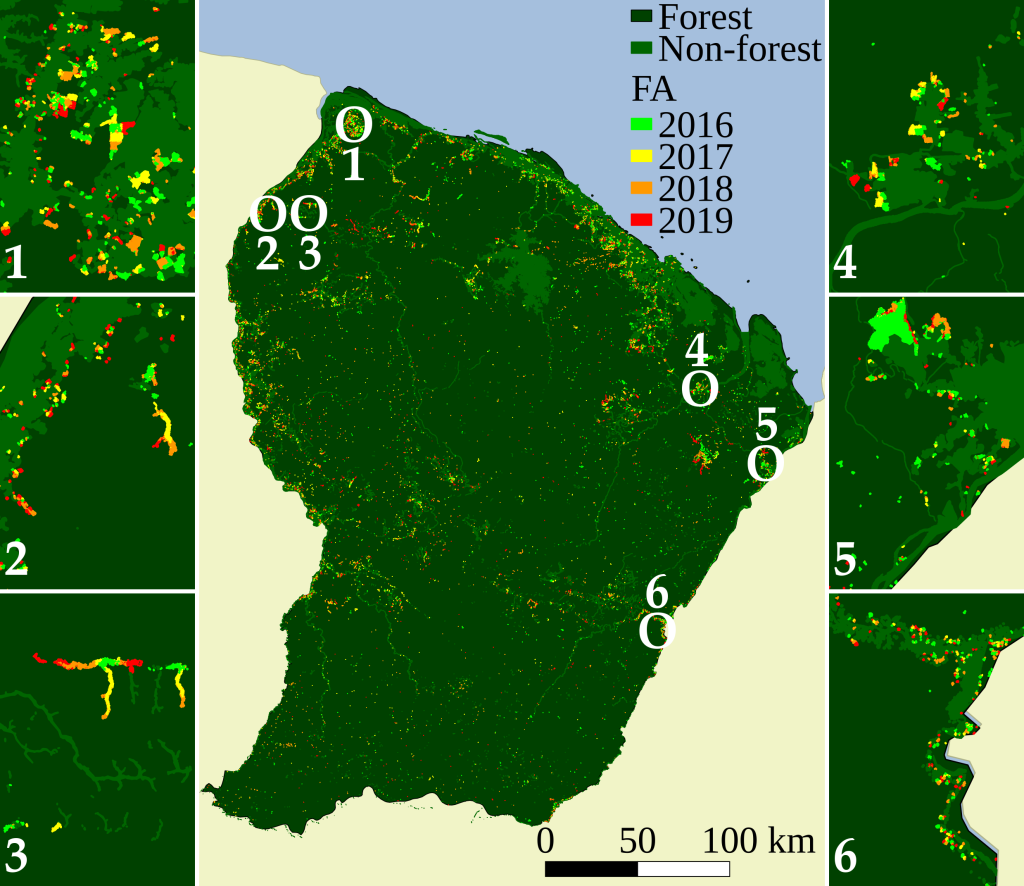
The Sentinel-1-based FA maps were also compared with an optical-based system that raises FA at the pan-tropical scale: the Global Land Analysis and Discovery (GLAD) FA by the University of Maryland. The optical-based FA showed 62.3% of producer’s accuracy and a systematic temporal delay relative to radar, up to one year. The temporal comparison regarding forest loss during the dry season showed little difference. In contrast, the optical-based FA showed a median temporal delay of 143 days (more than 4.5 months) regarding forest loss during the whole year, due to strong delays during the wet cloudy season.
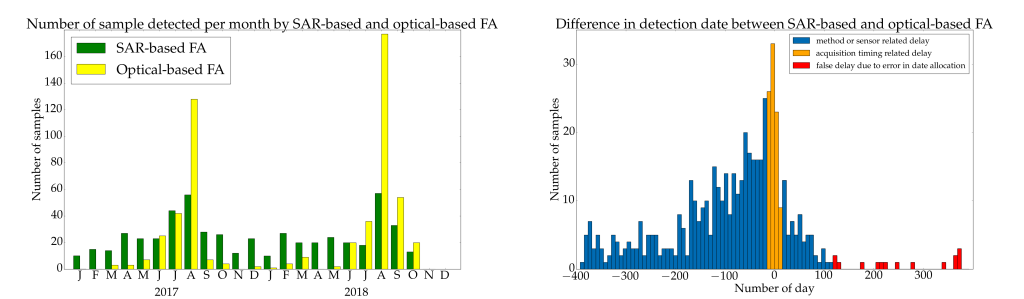
A field campaign in collaboration with the Statistics Service and the Prospective Department of the Ministry of Agriculture, which we thank, made possible the evaluation of the average absolute detection delay using the SAR-based method on 26 plots : 8 days.
These results highlight the benefits of SAR for forest loss alert detection in the tropics.
Subsequently, we plan to produce the map of the Guiana Shield (Suriname, Guyana, Amapa) and adapt and apply the method to other tropical countries.
References:
- Ballère, B., Bouvet, A., Mermoz, S., Koleck, T., Bedeau, C., Forestier, E., André, M., Le Toan, T., Frison, P.L. and Lardeux, C. SAR data for tropical forest disturbance alerts: Benefit over optical imagery – Study case in French Guiana. Submitted to Remote Sens. Environ. on Jan. 2020
- Bouvet, A., Mermoz, S., Ballère, M., Koleck, T., Le Toan, T., 2018. Use of the SAR Shadowing Effect for Deforestation Detection with Sentinel-1 Time Series. Remote Sens. 10, 1250.
- Hansen, M.C., Krylov, A., Tyukavina, A., Potapov, P.V., Turubanova, S., Zutta, B., Ifo, S., Margono, B., Stolle, F., Moore, R., 2016. Humid tropical forest disturbance alerts using Landsat data. Environ. Res. Lett. 11, 034008.
- Olofsson, P., Foody, G.M., Stehman, S.V., Woodcock, C.E., 2013. Making better use of accuracy data in land change studies: Estimating accuracy and area and quantifying uncertainty using stratified estimation. Remote Sens. Environ. 129, 122–131.