[VENµS] Full reprocessing of VM1 data available
The full reprocessing of VENµS VM1 data acquired between end 2017 and end 2020 has just been completed, with improvements for the Level 1C and level 2A processing. The data can be downloaded from the Theia website : https://theia.cnes.fr by clicking on VENµS VM1 (The data from VENµS new on-going phase, with a revisit of one day on most sites, can also be accessed by clicking on VENµS VM5)
L1C processing
For the Level 1C, the main efforts were focused on increasing the percentage of valid scenes. Without ground control points, Venµs images would have geolocation errors of a few hundreds of meters. To improve the geolocation and the multi-temporal registration of images to a fraction of the resolution (5 m), ground control points are used, obtained by matching the images to a well geolocated reference image. In the past, this was done by selecting a cloud free Venµs image which was then carefully geolocated. But it turned out that a large number of sites tend to show large seasonal variations. With larger field of view instruments, such as Sentinel-2, it is still easy to find invariant landscapes, such as cities, rocks, coasts… But with a field of view of 30 km, our method struggled to finding good matching points between a winter and a summer image, all the more so when parts of the images were cloudy. This resulted in a high percentage of invalid images because the number of quality GCP was too low.
In this new reprocessing, reference images from two seasons have been used to process most of the sites. The image matching parameters and the thresholds were also optimized to provide a better percentage of valid images. It was a success, as the percentage of valid images increased from 48.5 to 53.4 %, with a gain of 3500 images.

Some other marginal improvements were brought on the radiometric calibration and the L1C cloud detection, which uses the 2° parallax between two identical bands.
L2A processing
For the L2A processor, MAJA, the estimation of aerosols relies on two criteria :
- a multi-temporal one, that assumes the surface reflectances change slowly with time
- a multi-spectral one based on a relationship between the blue and red band.
Our validations using Aeronet showed that the coefficients of the relation between the blue and red band was not perfectly tuned, which caused a negative bias on the surface reflectances after atmospheric correction (these reflectances were too low, and sometimes negative). A better tuning has now been implemented and used in this reprocessing.
We also benefitted from the last version of MAJA, which enables to use CAMS data to set the type of aerosols, or to process the cloud masks at a better resolution (100 m)
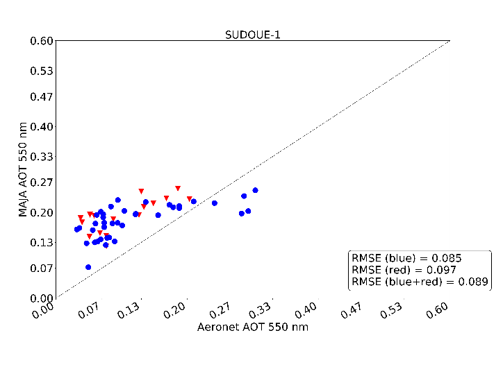
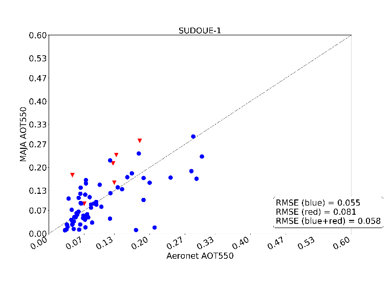
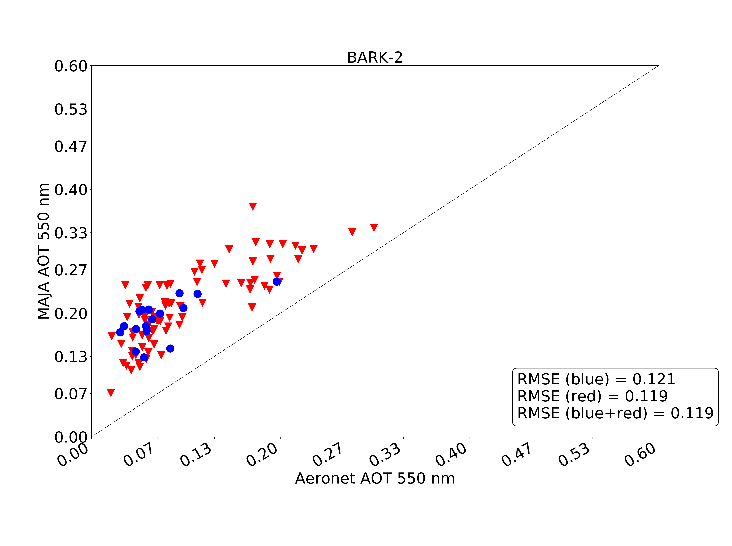
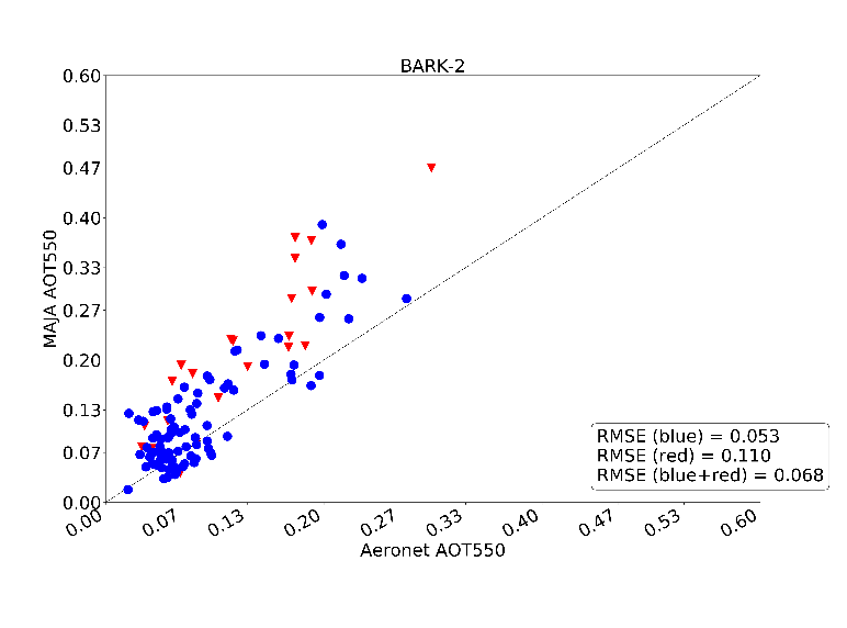
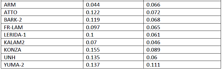
Here are some validation results for the aerosol optical thickness measurements :
| First processing | New processing |
|---|---|
 |  |
 |  |
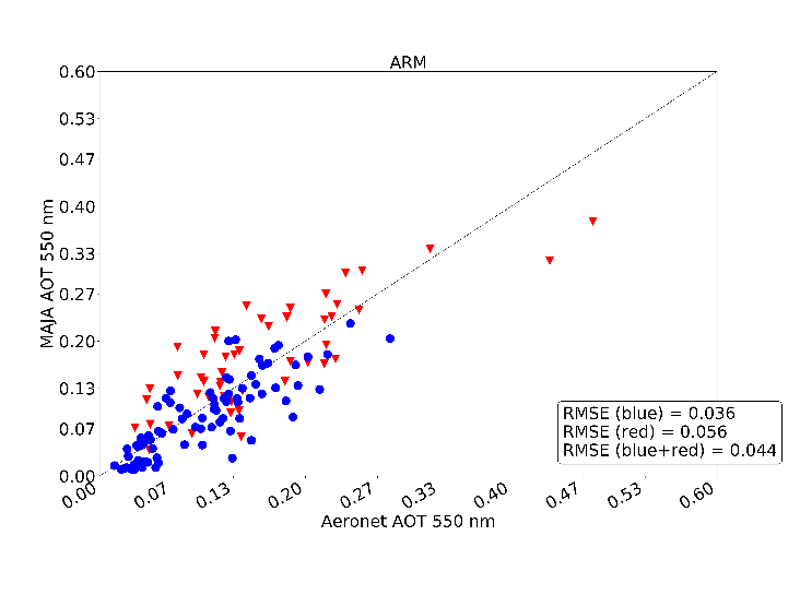 | 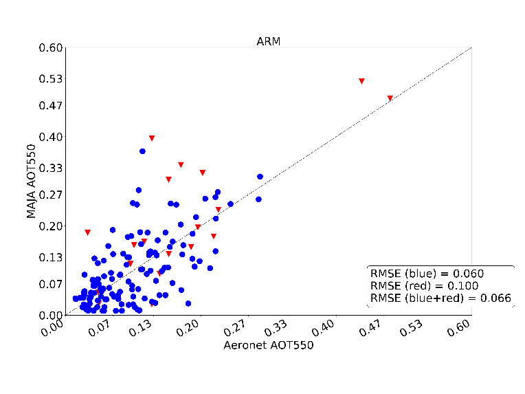 |
One can note that for all the sites but the last one one, we have a large improvement of the rmse error. In fact, in the first processing, only the ARM site was used to set the parameters of the multi-spectral criterion to detect the aerosols. It was an error. It turned out that that site has a very reddish soil, and the coefficients that we derived there were not at all optimised for the other sites. Here we used some average coefficients that improve the results generally, but degrade them on the ARM site.
Who did it ?
The improvements of Level 1C processing were brought by Arthur Dick (CNES) for radiometry and by Amandine Rolland (Thales) for the geometry, and of course with the help of the production team, while the improvements of Level 2A and the validation of the results were brought by Sophie Coustance (CNES). The whole reprocessing also required lots of efforts from the production and development teams at CNES (VENµS and THEIA ground segments). In particular many thanks to Marie France Larif (CNES), and Gwenaelle Baldit (Sopra Steria).