Copernicus should keep S2A operational after S2C launch
The launch of Sentinel-2C (S2C) is scheduled on the 4th of September 2024, next week ! After 3 months of commissioning phase, S2C will replace S2A, to fulfill the Sentinel-2 mission together with S2B. S2B will later be replaced by S2D. The current plans are to keep S2A as a redundant satellite, in case something happens to one of the two other satellites. It seems likely that S2A will stop acquiring images once S2C is operational.
I guess the decision not to keep S2A operational would be for cost reasons. The operation costs are high : although I have no information, I guess these costs are on the order of magnitude of one or two dozens of millions per year. My reference is the SPOT4 (Take5) experiment which cost ~1 M€ for a few months with a limited amount of data. In the case of S2, the data volumes to download, process and distribute are huge, and ESA would also need to monitor data quality, have a tighter orbit and attitude control… Anyway, the cost of operating a satellite is much lower than the cost of the satellite itself (Sentinel-2B’s price was a few hundreds of M€).
I am very proud Europe was able to build the Sentinel-2 mission with a revisit of 5 days and funding of 20 years of operations, including two replacement satellites. But we could do even better for a limited cost. I write this letter to try to convince scientific, public and private users that 5 days revisit is not enough. We should therefore try to set-up a campaign to ask ESA/UE to reconsider the decision to end S2A imaging operations when S2C is operational. Help, feedback and ideas are welcome !
A petition is available here.
Revisit needs
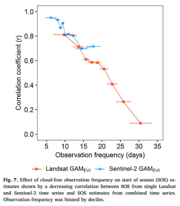
As an example, here are the cloud free revisit needs expressed by the vegetation monitoring community.
- Land cover classification : a clear observation per month
- Biomass/Yield estimation : a clear observation per fortnight
- Phenology (start and end of season, flowering…) : a clear observation per week
Waters, especially coastal waters, tend to change even quicker, with the additional drawback to be affected by the reflection of the sun on water, on one third to one half of the acquisitions.
Very recently, several papers have studied the biases due to the insufficient and irregular observations from space optical missions. Bayle et al, 2024 show that part of the observed greening of mountains observed on the Landsat time series acquires during decades is in fact due to the increase of the revisit frequency, which is still not always sufficient to capture the short-lived peak of greenness in alpine ecosystems. Langhorst et al, 2024 show that the loss of observations due to clouds leads to miss important hydrological events that bias statistics.
5 days revisit is not enough
The global average cloud cover is 70%, with of course large variations across seasons and location. It means that on average, for a given pixel, two observations out of three are cloudy. But if you need to observe a large area simultaneously cloud free, it is even more difficult. I don’t have statistics on that, but roughly only 10% of Sentinel-2 products on 100×100 km² are fully cloud free.
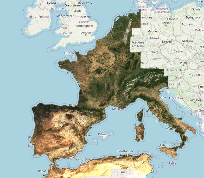
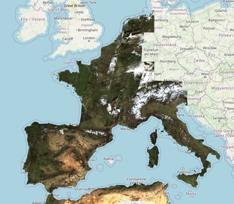
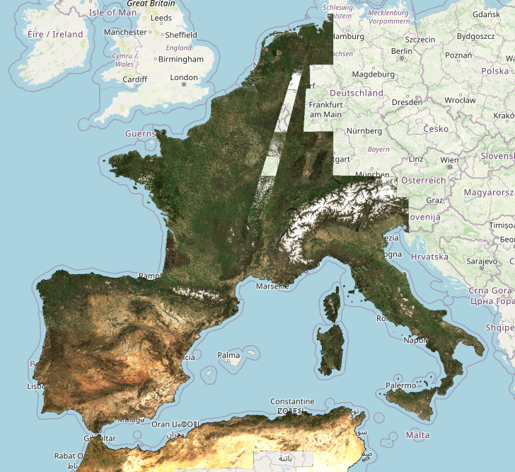
Due to the fact that the great majority of images have clouds, our users have asked for cloud free periodic syntheses. At the THEIA land data center, we produce every month surface reflectances syntheses (named « Level3A » products). Our WASP processor computes a weighted average of all the cloud free surface reflectances found during 46 days (from 23 days before to 23 days after the synthesis date). When no cloud free data is available, we raise a flag, and provide one of the cloudy reflectance values acquired during the period. These regions appear in white (but don’t confuse them with snow in mountains).
Since these syntheses use 46 days, and not 30 days, they do not meet any of the needs explained above. The 46 days duration was tuned to have less than 10% of pixels always cloudy on average per synthesis. Here are some examples.
South-Western EU
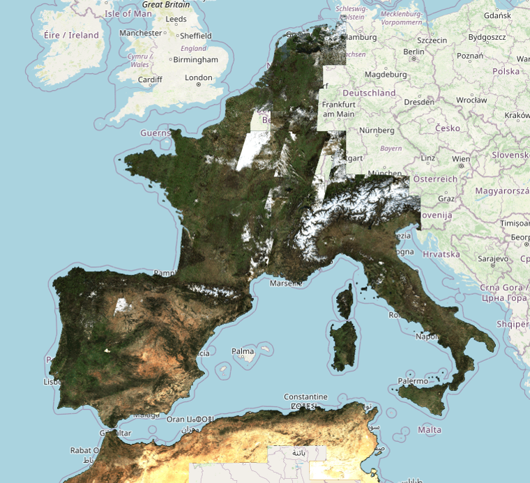
Over western Europe, the top left image shows a summer drought period, with a reduced amount of always cloudy pixels. However, some are visible in the East of Belgium/Netherlands. The images in winter have large region with no cloud free data, and even in April 2023, there is a remaining cloudy region in the east of France. You might have noticed that the remaining regions often have a trapezoidal shape. It is explained by the fact that Sentinel-2 swaths overlap, and it is of course more likely to miss cloud free pixels where we have two observations every 5 daysinstead of one. More examples are available at THEIA : http://maps.theia-land.fr
| : July 2022 (Drought in Europe) | December 2022 |
|---|---|
 |
|
| January 2022 (a dry January ) | April 2023 |
 |
 |
Germany
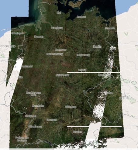
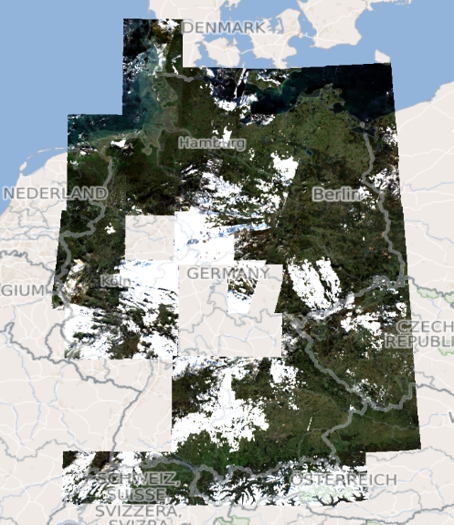
South-Western Europe is blessed by a nice weather (when it’s not too hot), but Germany has a lot of clouds. Our colleagues form DLR also process Level3A syntheses with our tools. Here are some examples. You may also see by yourselves at this address : https://geoservice.dlr.de/web/maps/sentinel2:l3a:wasp
Norway
Norway cartographic agency (Kartverket) also uses our softwares MAJA and WASP to produce countrywide syntheses, but they had to change the parameters to obtain a correct result. Summer syntheses are produced each year, but they often need a manual post-processing to enhance the results where some clouds are remaining. This is despite the orbits fully overlap in Norway.
https://kartkatalog.geonorge.no/metadata/satellittdata-sentinel-2-skyfri-mosaikk-wms/38a52b73-2ffb-47cc-9ecd-147ee18f62be
Consequences
The main consequence of persistent cloudiness on S2 images is that our observations are quite far from the expressed needs, except in the sunniest countries. As a result, studies and retrievals are not as accurate as they could be, biases and noise appear. In my sense, the main issue is the fact that persistent clouds on images introduce a random unreliability, that prevents to provide an operational service.
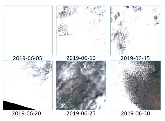
One of the most acute cases in my memory happened in June 2019. The region near Toulouse suffered a long and early heat wave, but clouds were present every 5 days in the morning, when S2A or S2B were acquiring data. During a heat wave,it is very hard to explain local customers that the product didn’t work because of clouds.
As a result, insufficient revisit hampers the development of services based on optical images.
There are some ways around, using Landsat 8 and 9 (but resolution is 30m), Sentinel-1 (but SAR provides a completely different information), Planet (but only 4 bands, very expensive if you need to work at country scale, and not the same quality). Moreover, Planet uses Sentinel-2 a lot to improve its products. A better availability of S2 data would also improve the data quality of Planet data and the soon to be launched Earth Daily constellation.
Dear EU, please keep S2A operational !
That’s why it would be a pity not to go on using S2A after S2C commissioning phase. With three satellites, S2A passing for instance two days after S2B, we could produce cloud free syntheses every 20 days, based on 30 days of data only. We would be closer to the needs, and would reduce a lot the unreliability of S2 services.
Of course, it means an increase of data volume and processing costs, but it is only a few % every year of the cost of one satellite. If it is really too much, let’s do it over Europe only, as S2 is funded by Europe. Maybe EU fears that if we ask for it, users of the other Sentinel missions will also ask for it. But S1 does not have clouds (and S1B has been lost) and S3 has a daily overpass already. Therefore, there are good reasons to operate a third satellite in the case of S2 only.
If you agree or disagree with me, or if you have more arguments to provide, please add a comment to this page !
Petition
I am not sure it is the best way to have influence on Copernicus, but I have set up a petition on an ethical web service provider, feel free to sign here : https://pytition.ethibox.fr/petition/user/ohagolle/keep-s2a-operational-after-s2c-launch
References :
- Bayle, A., Gascoin, S., Berner, L.T. and Choler, P. (2024), Landsat-based greening trends in alpine ecosystems are inflated by multidecadal increases in summer observations. Ecography e07394. https://doi.org/10.1111/ecog.07394
- , , & (2024). Global cloud biases in optical satellite remote sensing of rivers. Geophysical Research Letters, 51, e2024GL110085. https://doi.org/10.1029/2024GL110085

