TropiSCO : a project to monitor tropical deforestation with Sentinel-1 on a weekly basis
Do we need to remind you of all the collateral damage linked to deforestation or the eco-system services that forests provide ? We have already talked about these in this blog (here and there too). Yet forests are disappearing at an alarming rate. Between 1990 and 2020, an area of forest equal to more than three times that of metropolitan France has disappeared. The tropical forest, which accounts for half of the world’s forests, is seriously threatened: in 2019, the equivalent of a soccer stadium is destroyed every two seconds (FAO, 2020).
Yet France is about to acquire a tool for monitoring deforestation thanks to the TropiSCO project, which has just been labelled by the Space Climate Observatory, which we call the SCO. Within the framework of this project, the deforestation detection method developed by CESBIO, GlobEO and CNES (Bouvet et al., 2018; Ballère et al., 2021) will be applied to humid forests in all the tropics, and possibly to temperate and boreal forests. This observation tool will be ready within 18 months and the produced data will be made public.
This deforestation detection method is especially suited to the tropics since it is based on data from the Sentinel-1 radar satellite, which is almost insensitive to the clouds that obstruct most optical images in these regions. Deforestation is therefore detected every week regardless of weather conditions, at 10 meters resolution. According to Ballère et al (2021), in a third of the cases, our method detects deforested areas more than 3 months ahead of the method used by the Maryland GLAD team (Hansen et al., 2016) which is based on optical data from Landsat. Our method has already been applied to different areas of the tropics (French Guiana, Peru, Gabon, Vietnam, Laos and Cambodia) and successfully validated. TropiSCO is therefore an early warning system, but not only, since the results can be used to reliably calculate annual deforestation statistics.
The data produced is likely to be of interest to many users, including governments, NGOs, universities, the general public, but also companies wishing to reduce the risk of deforestation in their supply chains or fire monitoring actors.
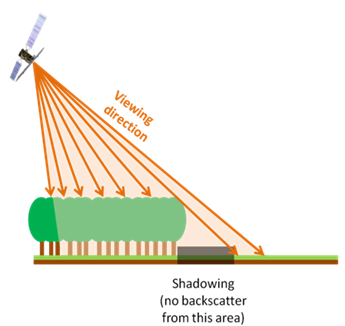
It is important to note that similar initiatives based on the use of Sentinel-1 data are currently emerging, such as the Wageningen University’s RADD alert system (Reiche et al., 2021) and the Brazilian alert system (Doblas et al., 2020). However, our method based on radar shadow detection has the advantage of effectively avoiding false alarms.
The project’s labeling by the SCO provides us with funding to precisely define the architecture of the production system and finalize the demonstration mock-ups to distribute the first data and obtain feedback from users. In parallel, and with the assistance of the SCO team at CNES, we will quickly finalize the financing of the project development and production for three years.

Références :
Ballère, M., Bouvet, A., Mermoz, S., Le Toan, T., Koleck, T., Bedeau, C., … & Lardeux, C. (2021). SAR data for tropical forest disturbance alerts in French Guiana: Benefit over optical imagery. Remote Sensing of Environment, 252, 112159.
Bouvet, A., Mermoz, S., Ballère, M., Koleck, T., & Le Toan, T. (2018). Use of the SAR shadowing effect for deforestation detection with Sentinel-1 time series. Remote Sensing, 10(8), 1250.
Doblas, J., Shimabukuro, Y., Sant’Anna, S., Carneiro, A., Aragão, L., & Almeida, C. (2020). Optimizing Near Real-Time Detection of Deforestation on Tropical Rainforests Using Sentinel-1 Data. Remote Sensing, 12(23), 3922.
FAO : State of the World’s Forests 2020. http://www.fao.org/state-of-forests/en/
Hansen, M. C., Krylov, A., Tyukavina, A., Potapov, P. V., Turubanova, S., Zutta, B., … & Moore, R. (2016). Humid tropical forest disturbance alerts using Landsat data. Environmental Research Letters, 11(3), 034008.
Reiche, J., Mullissa, A., Slagter, B., Gou, Y., Tsendbazar, N. E., Odongo-Braun, C., … & Herold, M. (2021). Forest disturbance alerts for the Congo Basin using Sentinel-1. Environmental Research Letters, 16(2), 024005.
