HR TIR DA IRL (High Resolution Thermal Infra-Red Directional Anisotropy In Real Life)
 =>
=> 
In the frame of the preparation of the Trishna mission, one important question is : do we have to correct for directional effects, and how should we do it ? Some of you may be familiar with the so-called hotspot effect in the reflective domain, which is well illustrated on our blog. Well in Thermal Infra-Red domain, directional effects are not caused by direct reflection of the sun light, but rather by the change of proportion between shaded, cooler elements and sunlit, hotter elements within the pixel. Another effect, called gap fraction, also relates to a change in proportion between vegetation and ground seen in the pixel, since they have very different emissivities. Those proportions continuously change with the satellite viewing angles, and when the viewing angles of the satellite perfectly align with the sun angles, the shaded elements become invisible in the pixel, resulting in a higher observed temperature. Given the wide field of +/-34° of Trishna sensor, this will be occuring quite often depending on the season and the location.
It is noteworthy that the Land Surface Temperature (LST) is not as stable in time as Land Surface Reflectance (SR), since temperature is mainly driven by meteorological forcing and daily sun cycle. Therefore, if directional effects in TIR domain are well modeled by radiative transfer codes such as SCOPE or DART, and sometimes captured by instrumented field studies, they are quite hard to observe in real satellite data, especially in the High Resolution range (below 100 meter). At CESBIO, we went on a hunt (well actually, more a fishing party) in the wide lake of publicily available remote sensing data, and – luckily – we got a catch. You can read the full story here (or the preprint on HAL):
Julien Michel, Olivier Hagolle, Simon J. Hook, Jean-Louis Roujean, Philippe Gamet, Quantifying Thermal Infra-Red directional anisotropy using Master and Landsat-8 simultaneous acquisitions, Remote Sensing of Environment, Volume 297, 2023, 113765, ISSN 0034-4257, https://doi.org/10.1016/j.rse.2023.113765.
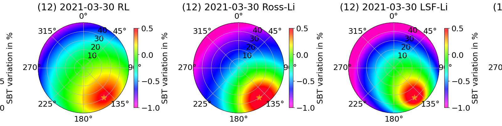
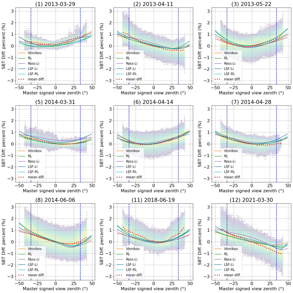
By leveraging the MASTER airborne wide field of view sensor from NASA (with the kind support from JPL) and Landsat-8 near simultaneous acquisitions, we were able to observe the LST almost simultaneoulsy (less than 15 minutes appart) acquired under different viewing angles, for 9 scenes in California, 3 of which are close to hotspot conditions, as can be seen in the figure below (tracks (2), (8) and (12)).

We observed a LST difference of up to 4.7K within the future viewing angle of Trishna. By fitting parametric models from the litterature, we were able to reduce this error below 2K in all cases, though our experiments did not allow to determine which model should be preferabily used. The figure below shows how well the different models fitted the directional effects, when fitted on all tracks at once.
Another interesting outcome of this study is the sensitivity to land cover and vegetation growing stage. In theory, model parameters should be driven by those factors. Indeed, the mix between shadow/sunlit and vegetation/bare soil should change more dramatically with intermediate vegetation covers. However, when we tried to relate the difference between MASTER and Landsat-8 observed temperature to a combination between a landcover class from Copernicus (Global Land Service maps) and NDVI stratas from Landsat-8 for the growing stage, we did not observe significant trends: all classes behave alike, as shown in the figure below. From this experiment we should not conclude that land-cover and vegetation growth stage is not important for directional effects mitigation, but rather that current available sources of land-cover are probably too coarse and imprecise to be used for the correction of directional effects.

While there is still a lot to do to get operational directional effects corrections in up-coming ground segments, this study shows that on a limited set of real life scenes (from California), parametric models from the litterature with a fixed set of parameter can be used to mitigate the impact of those effects. It also advocates for larger dedicated airborne campaigns (outside of California) with simulatenous flight with Landsat-8, so as to qualify and calibrate those models on a wider range of landscape and conditions.