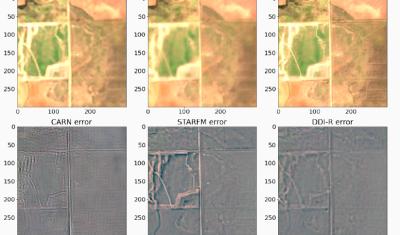
Sentinel-2

Rupture du barrage de Kakhovka : que nous montrent les satellites ?

La rupture du barrage de Kakhovka au sud de l’Ukraine a eu lieu tôt le matin du 6 juin 2023. L’évolution de la hauteur d’eau du lac mesurée par altimétrie satellite est disponible sur Hydroweb. On peut constater que le niveau du lac est passé de 13,80 m le 8 juin à 08:18 à 11,86 […]

11.06.2023

A new article on the validation of MAJA’s Sentinel-2 surface reflectances

Whether you are a user of the atmospheric correction processor MAJA or THEIA’s Sentinel-2 Level 2 products, you will probably be interested to read our new article on the validation of MAJA Sentinel-2 surface reflectances. The article is published in open access in Remote Sensing : Colin, J.; Hagolle, O.; Landier, L.; Coustance, S.; Kettig, […]

22.05.2023

The Million : The MUSCATE data center at CNES already delivers one million products

=> The Million ! If you sum up the numbers of products distributed by CNES for THEIA, you can see that our center is now distributing more than one million products (1,000,000!). Readers who follow this blog may remember our initial struggles related to the production, after which we celebrated 10,000 (in April 2017) or […]

29.03.2023

Le Million : le centre de données MUSCATE au CNES a mis à disposition plus d’un million de produits

=> Le Million ! Si vous calculez la somme des nombres de produits distribués par le CNES pour THEIA, vous pourrez voir que notre centre distribue maintenant plus d’un million de produits (1 000 000 !). Les lecteurs qui suivent ce blog se souviennent peut-être de nos difficultés initiales, qui nous poussaient à célébrer les […]

Télédétection de l’orientation des cultures

(article publié aussi sur le site du labo-OT au CNES) Pourquoi s’intéresser à l’orientation des cultures agricoles ? Au moins pour deux raisons. L’orientation des cultures par rapport à la pente du terrain contribue de façon importante au risque de ruissellement intense et par voie de conséquence à l’érosion des sols. Par ailleurs, connaitre l’orientation des […]

22.03.2023

A new downloader to access individual files within the zip distributed by THEIA

Downloading time series from Theia can take a while, depending on the area and the time period covered by the images. Also, it consumes a lot of storage locally, since all the archives in .zip format have to be downloaded (the GeoDataHub will probably distribute Cloud Optimized Geotifs). From my experience, a lot of people […]

21.03.2023

A 10 m resolution land cover map of Sahel with iota2

iota2 is the large scale mapping software developed at CESBIO. iota2 takes high resolution satellite image time series (SITS), usually Sentinel (1 and 2) or Landsat, and produces maps over large areas. Maps of most usual variables of interest in remote sensing can be produced, since iota2 can compute user-defined functions at the pixel level, […]

09.01.2023

Some news from ESA regarding the coming launches of Sentinels 1 and 2

In this article, ESA gave us some news of the time table for the coming launches of next Sentinel1 and 2 satellites. As you may have heard, we have these days a shortage of European launchers, due to the ending of Soyouz launches from Kourou, the delays in Ariane 6 delivery, and the initial uncertainties […]

08.12.2022

Feedback on hydrological monitoring of Telangana region in India using remote sensing

=> Claire Pascal, PhD student at CESBIO, under the supervision of Olivier Merlin (CNRS researcher) and Sylvain Ferrant (IRD researcher) brilliantly defended her thesis on the monitoring of water resources by satellite on November 18. Claire’s work focused on the Telangana region of India where rainfed cotton and flooded rice farming dominate. The region has […]

01.12.2022

Rechercher