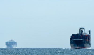
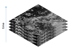
Visualizing shipping lanes from Sentinel-1
I found in Twitter [1,2,3] that a simple way to visualize the sea lanes is to compute the maximum of each pixel across a time series of Sentinel-1 images.
I found in Twitter [1,2,3] that a simple way to visualize the sea lanes is to compute the maximum of each pixel across a time series of Sentinel-1 images.

(English version below) Dans le cadre du projet Simult’eau (partenaires : Arvalis, CACG, Chambres d’Agriculture du Tarn et des Hautes-Pyrénées, financement CASDAR) nous avons testé l’apport d’une utilisation combinée des images radar et optiques pour la cartographie des surfaces irriguées (maïs et soja) dans le Sud-Ouest de la France. Les résultats publiés dans Remote Sensing […]
=> Sentinel-1 is currently the only system to provide SAR images regularly on all lands on the planet. Access to these time series of images opens an extraordinary range of applications.In order to meet the needs of a large number of users, including our needs, we have created an automatic processing chain to generate « Analysis […]
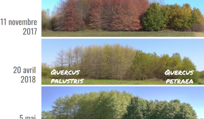
Le pôle toulousain de recherche publique en télédétection est surtout connu sur la thématique forestière grâce à la mission BIOMASS, qui sera lancée vers 2021 et qui est portée par le CESBio, mais qui concerne surtout les forêts tropicales. L’objectif de cet article est de présenter les travaux en cours sur les forêts tempérées, dans […]
=> Sentinel-1 est actuellement le seul système à fournir des images SAR régulièrement sur toutes les terres de la planète. L’accès à ces séries temporelles d’images ouvre un champ d’application hors du commun. Afin de répondre aux besoins d’un grand nombre d’utilisateurs, dont les nôtres, nous avons créé une chaîne de traitement automatique permettant de […]
[This post was written by Simon Gascoin and Sylvain Ferrant] The Lao News Agency reported that the Xe-Pian Xe-Namnoy dam collapsed on Monday causing catastrophic flash floods. « The disaster has claimed several human lives [and] left hundreds of people missing, » the agency reported. Construction of the Xe-Pian Xe-Namnoy dam began in 2013. Commercial operations were […]
The French Sentinel mirror site, PEPS, has a very clever data management facility. All the products are stored on tapes, with a capacity of several PB, and there is some sort of cache made of disks. The products accessed recently are on disks, while the other products stay on tapes. The storage costs and also […]
You probably remember Simon Gascoin’s story about the Aru glacier avalanches, which started from Simon’s observations of the twin avalanches using the Sentinels. It was one of the big buzz pages of the blog in 2016. The first images were published here, then spread out in many scientific websites and the social networks. It seems […]

=> Translated from Theia website.The Theia forges just released a new product based on Sentinel-1 and 2 data. Le « High resolution soil moisture » Scientific Expertise Center, driven by Nicolas Baghdadi, from Tetis lab in Montpellier and Mehrez Zribi from CESBIO, distributes Soil Moisture maps from the French Occitania region at 20 m resolution, produced every […]