Xe-Namnoy lake dam failure
[This post was written by Simon Gascoin and Sylvain Ferrant]
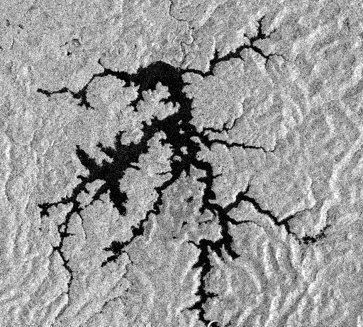
The Lao News Agency reported that the Xe-Pian Xe-Namnoy dam collapsed on Monday causing catastrophic flash floods. « The disaster has claimed several human lives [and] left hundreds of people missing, » the agency reported. Construction of the Xe-Pian Xe-Namnoy dam began in 2013. Commercial operations were expected to begin in 2018. The animation below shows the water filling using a time series of Sentinel-1 images (IW orthorectifed VV only descending orbits).
Post-event Sentinel-1 images were not available yet at the time of writing. It seems that the flood was caused by a breach in saddle dam D (i.e. not the main dam) after heavy rainfalls.
The Sentinel-1 image of today was available tonight in the EO-Browser: it shows the impact of the dam failure on the lake area

The effect of the dam breach is clearly visible at larger scale. The flood came from a saddle dam breach and followed the Vang Ngao river down to the villages (click on the animation below to see a larger version).

The other dam lake (Houay Ho) has grown over the same period but did not collapse. There are many flooded areas along the Kong river near Attapeu which were caused by the heavy rainfalls. A Sentinel-2 image was also captured on July 25 and shows the muddy water that flooded the villages near Hinlat and Ban Mai.
According to Lao News Agency the lake released 500 million cubic metres of water. Given that the lake area is 33.8 km² [1], that would mean that the lake level has dropped by 15 m.
update July 27
Sylvain Biancamaria from LEGOS looked at the lake elevation from Sentinel-3 SRAL data. Some lake level observations are available in the eastern part of the lake between 2 Dec 2017 and 13 May 2018. Over this period, the lake level stayed close to 770.0 m (with respect to the WGS84 reference ellipsoid) with ~10 cm variability. This is consistent with the fact that the lake area (as observed by Sentinel-1) did not change over the same period. It seems that the lake was already full before the recent heavy rainfalls.

Notes
[1] I made this calculation in Google Earth Engine using the same script as for the Bakun lake. The polygon of the lake can be downloaded here.
Further reading
in the Treasures of Laos blog: http://treasuresoflaos.blogspot.com/2018/07/xepian-xe-nam-noy-dam-in-laos-collapsed.html
in the New York Times : https://www.nytimes.com/2018/07/25/world/asia/laos-dam-collapse-rescue.html