Composite (3A)

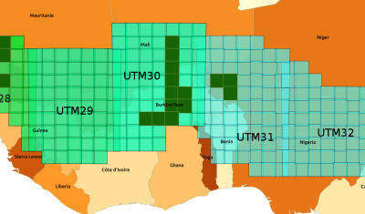
Special Noel THEIA: passage au fil de l’eau pour les traitements Sentinel-2 L2A et L3A sur la zone Sahel

=> Je profite de cet article pour vous souhaiter à tous de bonnes vacances, un joyeux Noel, et une excellente nouvelle année 2020 !   Il nous aura fallu près d’un an pour traiter les 300 tuiles de la zone Sahel de Theia, à partir de début Janvier 2017. Ce traitement s’achève ces jours-ci, il […]

La Garonne en crue à Tonneins. crédits: Amandine Gasparotto

En Français

Les inondations dans le Sud-Ouest vues par satellite

La Garonne a largement débordé entre Agen et Marmande comme le montre la comparaison ci-dessous entre une image prise par le satellite Sentinel-2 en décembre 2018 et une autre prise ce dimanche 15 décembre 2019 à la faveur d’une éclaircie (plein écran, animation): Les inondations sont aussi visibles le long de l’Adour entre Dax et […]

Composite (3A)

Sentinel-2 L2A (MAJA) and L3A (WASP) products, produced by DLR, available over Germany as WCS

In September 2019, the German Aerospace agency, DLR, started delivering Level-2A products (surface reflectances with a good cloud mask), using the MAJA L2A processor, to which DLR contributed with CNES and CESBIO.  The system received a major upgrade recently: it now includes L3A data (seamless monthly syntheses generated with our WASP processor), and both L2A […]

Composite (3A)

Persistent snow cover area in the Alps

These maps show the area that remained covered by snow from May 01 to Sep 01 over the past three years. It was computed from Theia Sentinel-2 snow products at 20 m resolution to capture the smallest snow patches.   In average there are about 1300 km2 (Lake Geneva: 680 km2) which remain snow-covered until […]

In English

20 m resolution snow maps, why bother?

« Snow varies. » (Snow scientist proverb) Sentinel-2 enables to generate snow maps at 20 m spatial resolution. But what’s the use of such high resolution snow maps? Because one picture is worth a thousand words, I resampled some Sentinel-2 images of snow-covered regions to coarser resolutions using the average reflectance of the contributing pixels. I did […]

snow-ice

Juste une meilleure image de couverture pour l’article de Simon ci-dessous

In English

How to find the closest snow to you?

If you live in Pamiers near Toulouse, France, where is the snow-covered place that is the fastest accessible by car or by bike? There is a beautiful snow map of the Pyrenees mountains near Pamiers from a Sentinel-2 image that was acquired yesterday (at the time of writing) [link to the data]. In QGIS with […]

En Français

Theia vous aide à trouver la neige la plus proche de chez vous

Si vous habitez à Pamiers, où se trouve la neige la plus rapidement accessible en voiture ? Theia nous fournit une belle carte de l’enneigement du 19 novembre 2019 dans les Pyrénées ariégeoises (lien vers les données). Dans QGIS avec l’API OpenRouteService on peut calculer les isochrones pour un trajet en voiture depuis Pamiers : […]

Composite (3A)

Theia starts producing Sentinel2 L3A products over Maghreb

=> Since October 2019, the Theia land data center started producing monthly cloud free and almost seamless syntheses, using Sentinel-2 data acquired on the Maghreb coastal regions, from Agadir to Djerba, passing through Rabah, Alger and Tunis. These syntheses, also called Level3A products, will be delivered every month, thans to the WASP processor, which was […]