How to find the closest snow to you?

If you live in Pamiers near Toulouse, France, where is the snow-covered place that is the fastest accessible by car or by bike?

There is a beautiful snow map of the Pyrenees mountains near Pamiers from a Sentinel-2 image that was acquired yesterday (at the time of writing) [link to the data].

Theia snow cover map on 19 Nov 2019

In QGIS with the OpenRouteService API it is possible to calculate isochrones for a car trip from Pamiers:

This map shows the areas accessible by car from Pamiers in a given period of time (yellow 30-40 min, orange 40-50 min, red 50-60 min)

Finally if we make a spatial join between this map and the vertices of the snow polygons, we obtain the following map:
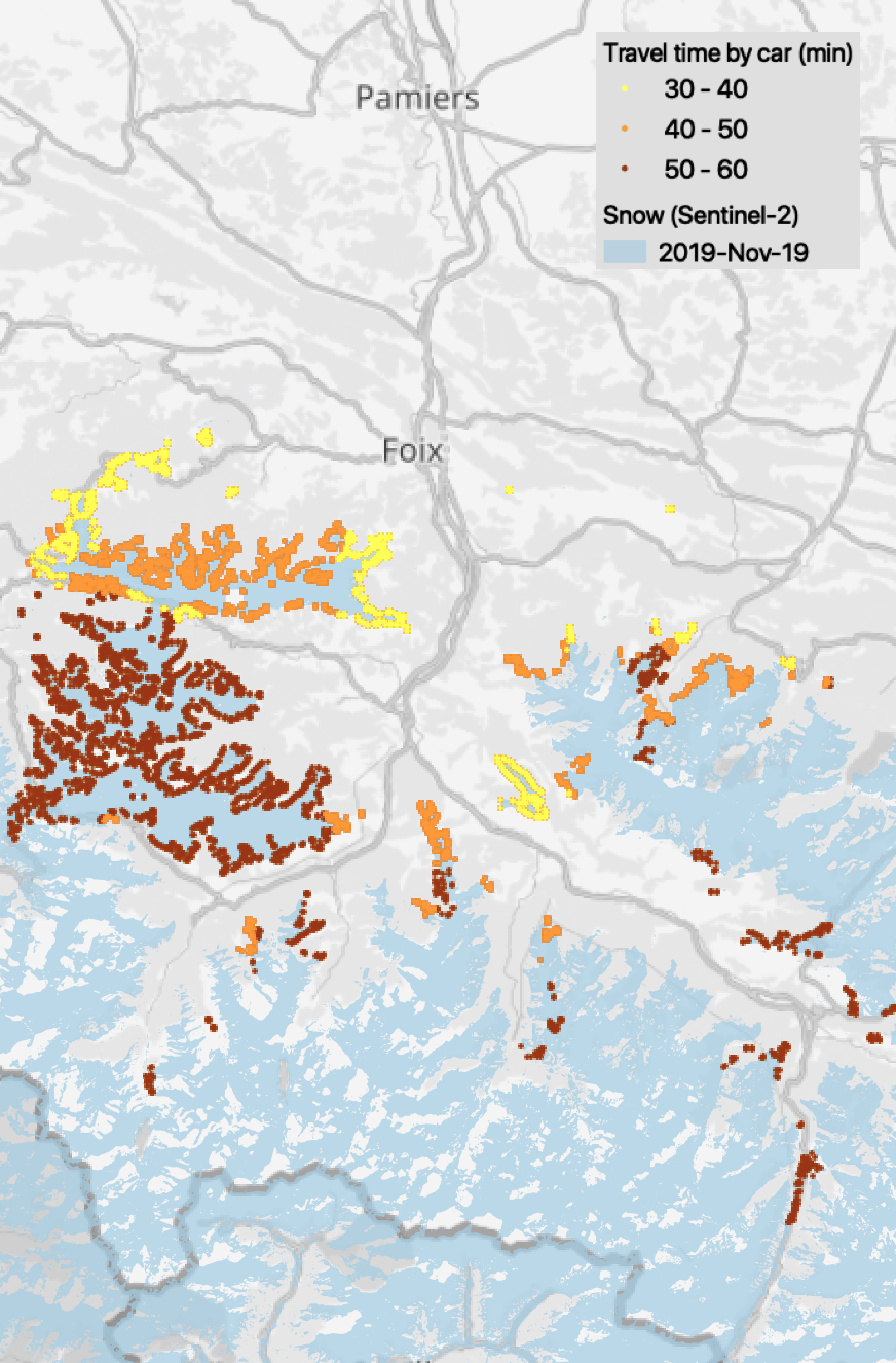
You can see in yellow the snow-covered places that are the fastest accessible according to OpenRouteService. Here is a zoom near Foix, there is a small road to reach the snow half an hour from Pamiers!

There are other APIs like OpenRouteService, for example that of Google enables to integrate traffic density in the calculation, but this service is not free. Beware that the time to mount the chains on the tires of the car is not taken into account …

You can even change the mode of transportation to calculate the travel time! Here the travel time is calculated for a cyclist from the city center of Foix.

Plus d'actualités

How long is the cooling effect of a cloud shadow ?

How long does it take for the cannon barrel to cool down after firing a shell ? Fernand Raynaud => This quote is from a famous old French funny sketch by Fernand Raynaud, which was based on a question in a French manual for soldiers: the sketch is rather long, so I’ll give you the […]

Impact of the August 12, 2026 eclipse on photovoltaic electricity generation in Spain

Photovoltaic (PV) energy supplies more 20% of Spain’s total electricity, and this share hit a new high in July 2026 (28.3% of the nation’s monthly electricity mix). Some media outlets were concerned about the drop in photovoltaic power generation during the 12-Aug-2026 eclipse. Le Monde explained that « the drop is expected to be particularly pronounced […]

Near real time snow cover maps in the Copernicus Browser!

Copernicus provides near real time snow cover maps at 20 m resolution (fractional snow cover, code name: FSC OG). These products have been recently reprocessed and are now available through the Copernicus Data Space Ecosystem (CDSE) API and visualization tool, the Copernicus Browser! The latter is very useful to explore the data, for example if […]

Rechercher