En Français

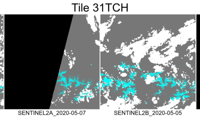
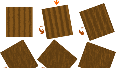
[Directional effects] Effects of crop orientation on surface reflectance

Introduction In the framework of our research for ESA concerning the maximum field of view of next generation of Sentinel-2 satellite, we searched for a way to estimate directional effects, without using a particular directional model to correct for these effects. The current directional models are imperfect, and we can assume that progress will be […]

BRDF

[Directional Effects] Validation of DART simulations of vineyards using VENµS multi-angular observations

Question: The color image displayed on the left is a new kind of RGB composite image, can you guess how it was made ? Hints: the blue bright pixels correspond to water, but water is not bright usually… except if it is obtained in specular condition, when the water surface mirrors the sun towards the […]

Applications

Impact du COVID-19 sur la pelouse du Centre Spatial de Toulouse

Le CNES a publié sur LinkedIn ces jolies photos du Centre Spatial de Toulouse après le confinement. Grâce aux satellites d’observation de la Terre, les ingénieurs du CNES sont capables d’étudier la végétation aux quatre coins du globe. Mais, les cordonniers sont souvent les plus mal chaussés… Pourraient-ils étudier leur propre pelouse par satellite ? […]

In English

Debris flow in the Ishkoman Valley

In July 2018, the Pamir Times has reported that a lake formed due to a debris flow in the Ishkoman Valley, Pakistan. This event caused the destruction of dozens of housed in Badswat and Bilhanz villages. The flood debris running down the slope hit the mountain on the opposite side, and formed a barrier, blocking […]

Applications

Benefits of SAR for forest loss alert detection in the tropics

The tropical forest is an important carbon sink which also hosts high biodiversity. Monitoring forest loss is therefore a major issue which requires efficient and accurate tools. In fact, the major challenge is to detect forest loss as precisely and quickly as possible, despite cloud cover which limits the availability of usable optical satellite imagery. […]

In English

Chaos theory, Rössler cake and satellite remote sensing

Chaos theory, Rössler cake and satellite remote sensing A chaotic attractor was obtained from satellite remote sensing data for the first time in 2011 giving a strong argument for chaos in real environment. This result has a special sound today May 20th 2020, since it is the 80th birthday of Otto E. Rössler — one […]

Code

Towards a composite of the most recent clear-sky observations from the Theia Snow collection

We are thinking of a new « live » product which would allow anyone to display the most recent snow observations from Sentinel-2 in a web browser. This service would simply display a composite of the latest Theia Snow products over a given time window (e.g. the past 20 days). This can be easily coded thanks to […]

Applications

Détection de la neige sur les routes avec Sentinel-2

France Bleu nous signale une impressionnante avalanche en Savoie près du Col du Glandon qui bloque la route Départementale 927. Les cartes d’enneigement distribuées par Theia permettent d’évaluer la présence de neige sur les routes de montagne grâce à leur haute résolution (pixel de 20 m). Une carte qui date du 09 mai (soit deux […]

Composite (3A)

Trouvez la neige à moins de 100 km de chez vous !

Voici un outil qui permet de trouver de la neige à moins de 100 km de chez vous ou dans votre département ! Cette app utilise les cartes de neige journalières produites par la Nasa à partir du capteur Modis sur le satellite Terra (MOD10A1.006). L’observation non-nuageuse la plus récente dans les dix dernières cartes […]