Free and open data pays off
As for most users of Copernicus or LANDSAT data I guess, the advantages of free and open remote sensing data are so clear that it’s hard to imagine they could be challenged. However, in the framework of Sentinel-HR phase 0, we prepared arguments in case our requirement for free and open data is questioned.
Table of contents
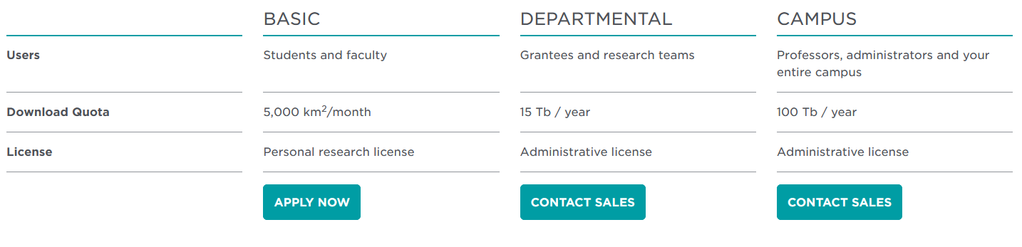
Why should users pay for data ?
The LANDSAT example
Economic benefits of free and open data
Social benefits of free and open data
Why should users pay for data ?
Of course, remote sensing data from private companies (Planet, Airbus, Maxar…) are not free. The hard work to make satellites and produce data must be funded and companies are there to earn money.
There has also been examples of state owned satellites whose data were commercialized, such as SPOT, Pleiades, and LANDSAT data at certain periods of time. With the exception of LANDSAT, Most of these data were provided by satellites which perform observations on demand. These satellites are tasked to optimize the acquisition according to the orders, and the satellites is oriented towards the site to acquire when it is possible. These satellites usually have a limited observing capacity, and in our capitalistic economies, asking a customer to pay is a classical way to choose which scene will be observed.
Thanks to the development of commercial satellites, the states are discharged of the necessity to fund the investment for the spatial infra-structure, and they can limit their intervention to missions which do not have a straightforward commercial application capacity. However, it turns out that states or local communities are also large customers for the data of these satellites, e.g. for the defense application, for research purposes, or for local land management. Finally, at the European scale, is it really cheaper to let the industry build and fund high resolution satellite missions and buy a large quantity of data, or to build public satellite missions which ensure a free and open access to data ? I think the latter is cheaper, except maybe for some niches, but feel free to correct me, I’ll be happy to learn.
When satellites have a sufficient observation capacity, they can become systematic observation satellites, which observe almost all the landscapes that enter their field of view, with no need to change the satellite orientation to observe a new scene. I only know one public decametric or metric resolution satellite mission that performed systematic observations and still tried to sell its data : the LANDSAT mission, until 2008.
The LANDSAT example
The information below comes from the following paper. Quoted sentences are in italics.
Michael A. Wulder, Jeffrey G. Masek, Warren B. Cohen, Thomas R. Loveland, Curtis E. Woodcock, Opening the archive: How free data has enabled the science and monitoring promise of Landsat, Remote Sensing of Environment, Volume 122, 2012, Pages 2-10, ISSN 0034-4257, https://doi.org/10.1016/j.rse.2012.01.010.
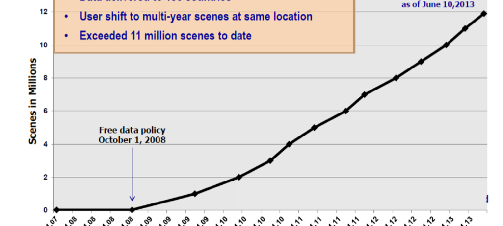
In October 2008, Landsat data became free and open data. Before that, costs for an individual photographic image varied from $20 (1972–1978) to $200 (1979–1982) for MSS digital data; digital data ranged from approximately $3000 to $4000 for TM data (1983–1998), and $600 for ETM+ data (1999–2008). Prior to October 2008, no calendar month ever recorded more than 3000 scenes sold in a given month.
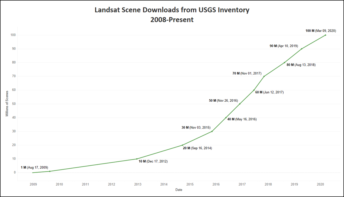
Here is what happened after October 2008 :
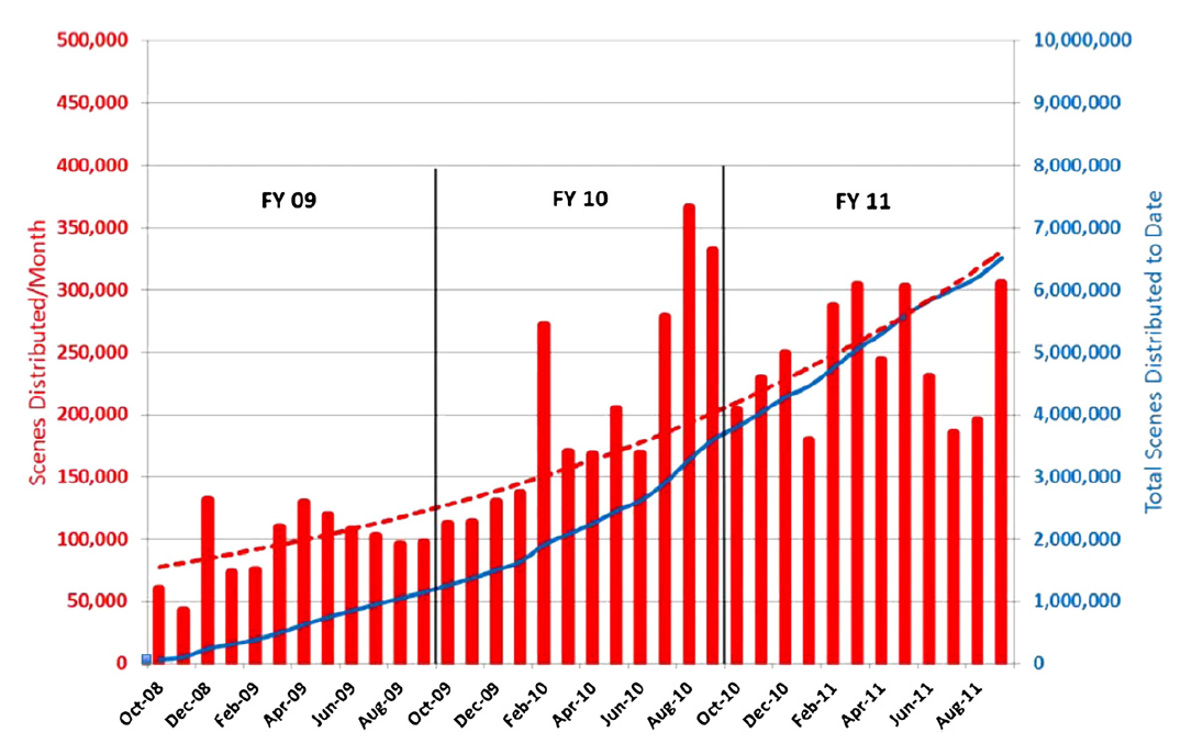
In less than three years, the number of tiles downloaded each month was multiplied by 100 ! But it was just the beginning, and in the next years, the download rate continued to increase until Sentinel-2 came into operation.
Economic benefits of free and open data
A few hours ago, the French Cartographic Institute (IGN) announced the release of its data bases as free and open data. This decision comes was justified by a report from the French Parliament : « It’s not the sale of data that creates its value, it is its circulation ». To justify this change of policy, the report states that : « Free dissemination and reuse of sovereign geographic data implies that the production of sovereign geographic data must be financed by the state subsidies, if not by the sale of the data. If the open data business model is empirically verified, a return to the public purse will be achieved by the taxes of the additional wealth created by the release of data. »
After a policy change was envisaged during the moderate center right Trump administration, the LANDSAT Science team studied the benefits of the free and open data policy of LANDSAT data, quoted sentences are in italics.
Zhe Zhu, Michael A. Wulder, David P. Roy, Curtis E. Woodcock, Matthew C. Hansen, Volker C. Radeloff, Sean P. Healey, Crystal Schaaf, Patrick Hostert, Peter Strobl, Jean-Francois Pekel, Leo Lymburner, Nima Pahlevan, Ted A. Scambos, Benefits of the free and open Landsat data policy, Remote Sensing of Environment, Volume 224, 2019, Pages 382-385, ISSN 0034-4257, https://doi.org/10.1016/j.rse.2019.02.016.
The National Geospatial Advisory Committee (National Geospatial Advisory Committee Landsat Advisory Group, 2014) analyzed sixteen economic sectors (e.g., agriculture, water consumption, wildfire mapping) where the use of Landsat data lead to productivity savings, and estimated the economic benefit of Landsat data for the year 2011 as $1.70 billion for U.S. users plus $400 million for international users. Many of the sixteen economic sectors are directly associated with U.S. federal, state and local government activities (e.g., risk assessments, mapping and monitoring activities). In addition, the open data policy is particularly beneficial to government, university, and commercial research groups and organizations that have limited budgets.
An economic study tried to measure the economic benefits of the Landsat open data :
John Loomis, Steve Koontz, Holly Miller, Leslie Richardson, Valuing Geospatial Information: Using the Contingent Valuation Method to Estimate the Economic Benefits of Landsat Satellite Imagery, Photogrammetric Engineering & Remote Sensing,Volume 81, Issue 8, 2015, Pages 647-656, ISSN 0099-1112, https://doi.org/10.14358/PERS.81.8.647
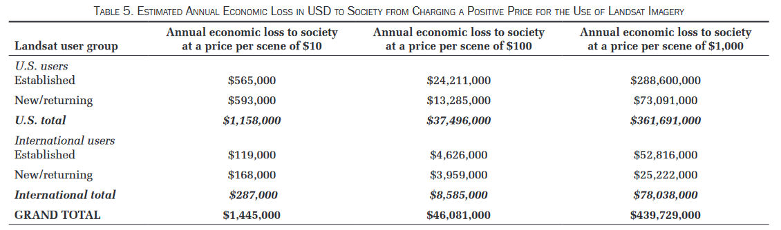
Based on a survey among 14 000 users of all sorts the authors tried to determine the value at which they would stop buying data and then how much benefit from the activity would be lost. The results are provided in the table below and show that at a cost of 100 $ per image, 46 M$ would be lost each year.
Of course, I have not enough economics skills to be able to criticize the study, but a sentence stroke me in the discussion, because I think we might be in that case : If the users who drop out of the market more quickly as the price per scene increases (i.e., they are not willing to pay as much per scene) obtain a greater share of the scenes than those users who stay in the market as the price in-creases, the results in Table 5 represent a lower bound on the annual economic loss to society associated with increasing the price of the imagery.
Let’s look at just one of the many products made at European Continental scale with Sentinel-2 data, in which CESBIO was involved, the snow and ice fraction cover product. This product is useful for hydrology purposes (how much water will be available for irrigation or to fill the dams after melting ?), for biodiversity (plants are different where the snow stays longer), for climate studies of course, as well as for recreational purposes (should I take snow equipment for my hike this week-end ?) This product involves 1500 tiles, 365/3 images per year (there is overlap in Northern regions, so one image every 3rd day on average), and we processed 5 years of data, in the past, and the exploitation will go on for 2 more years. The cost of the project was 1.5 M€, thanks to the free and open data. Let’s consider only a cost of 10 € per scene (which is probably a very low fee, Landsat data were sold 600 $):
- Number of images : 1500*365/3* 7*10 = 1 280 000
- Total data cost for a cost of 10 € per scene : 12.8 M€
The data cost would be almost 10 times the current cost of the project, and it probably means the project would not exist, and I doubt it would even exist with a cost of 1€. Could we imagine selling Sentinel-2 data at 1€ per image ? Well let’s see with planet. Planet has a special offer for research and education, which allows to download 5 000 km² of data for free. 5 000 km² is less than half the surface of a Sentinel-2 image. As this proposal is an incentive for future users, and as I expect planet to be more generous, I guess the cost of 5 000 km² is more than 1 €.
The Copernicus-NG study
The European Copernicus is preparing a new generation of the Sentinel 1 to 6 in the 2030 horizon. Before studying the new missions, a comprehensive study of user needs was done, which included an economic study to consider a possible change of data policy. It also includes a nice summary of the pros and cons of adding a fee to Sentinel-NG data.
Study on the Copernicus data policy post-2020, Nextspace Final Report. 2 February 2019
3 options were considered regarding data policy changes, the main option being keeping the current data policy :
- Allowing access only to European citizens
- Access allowed against a fee for all users with the exception of European public institutions
- Access allowed for all users, but with no right to redistribute data (except upon agreement). This option would enable to avoid Amazon or Google to get revenue from Sentinel-2 data.
As seen in the study, this would have difficult legal implications and diplomatic consequences (access for Europe to data from other countries could be denied), but let’s see the economic impact according to the study:
| Data policy options | 1 -access only in Europe | 2 - add fee on data | 3 - redistribution forbidden, except upon agreement |
|---|---|---|---|
| Operational costs/year | 7 M€ | 11 M€ | 9M€ |
| Loss in economic activity in Europe/year | 700 M€ | 2300M€ | 220 M€ |
| Activity loss in Europe, in percentage | -13% | - 48% | -5 % |
Economic impact of the three changes studied for Copernicus data policy
The operational costs would cover the need to enforce the regulations and to check users comply with the conditions. Of course, the option with a fee would require to set up services to advertise, negociate, recover the fees and provide support on the billing process.
The economical costs cover the fact that the data use relies on partners from outside Europe that would need to be replaces, by reduce export possibilities due to the restriction, and for the option 2 with fees, for all the activity that would not happen because of the necessity to pay for the input data. The study concludes, for option 2, that a reduction of the economic activity would be as high as 50%.
Although I have not heard if the Copernicus program intends to change something regarding the data policy, bades on the reports conclusions, it does not seem likely.
More economic considerations
How to start a new business based on remote sensing data ?
Now, imagine you are a company, and you have a good idea for a product that could be successful and generate revenue, for instance estimating evapo-transpiration in agricultural fields to provide advice on irrigation. To be credible, you need to demonstrate its over a region such as Occitania (10 tiles, 2 years). Can you afford to invest 180 k€ (10 x 365/4 x 2 x 100, assuming 100€ per image), just to make this demonstration ? Will you find funding for that, while you already need to fund the R & D investment ?
Without the free and open data policy, the EOX could not have made its fantastic cloudless global mosaic, which is perfect tool to explore our planet and a good showcase for EOX remote sensing skill. Without the free and open data, Sinergise Sentinel-playground would not exist, and Sinergise would probably still be a little software company. In France, Kermap, Geosys and many others benefit from these data.
Cloud processing
Given the data volume, the current tendency is to avoid data transfers and process the data where they are stored. We have seen a large number of private operators and public platforms proposing cloud computing facilities with access to the data archive. If data are not free, with a unique distributor, it will become more difficult for independent organizations to duplicate archives to propose them withing their platforms. Of course, contracts could be signed, but probably not for free, and if two data sources belong to two different operators, will they propose access to both of them ?
Cloudy data have value when they are free
Let’s forget the costs, budgets and suppose we are in a good society where users have some money to do their research. Of course they are asked to spare money and can’t buy everything they want. This image in November with 35% of clouds has the same price as a cloud free image in September, should they buy it ? As it happened for LANDSAT when the data had to be paid, only the almost cloud free images are paid, and more than half of the images are never ordered, while they have intrinsic value.
Social benefits of free and open data
Science for the citizens, NGO , journalists
I don’t have a statistics, but free and open data enable surveillance of our planet by citizens, NGOs, journalists. Just take a few examples from citizen Gascoin :
- A mining company polluted a Siberian river, in 2016, and Sentinel-2 witnessed it. In this case, it is true that free and open data can be detrimental to corporate profits (the company was fined).
- Scientists emitted a warning about a glacier about to collapse with Sentinel-1 data, triggering evacuation and maybe saving lives.

- A video with LANDSAT-8 data by Simon, on the dynamics of sand near the Bassin d’Arcachon was relayed in the local press draining a large number of connections to this blog, and raising awareness within the public. Simon would not have pulished this video, had he had to pay 5000 € for the images.
- Pierre Markuse great images of forest fires from Sentinel-2 or Landsat-8 are often used in the press, to inform the broad public on the magnitude of the affected regions.
Education
Free and open data are a great way to let students manipulate data and learn how to conduct a remote sensing project. A lot of the cloud platform users are students, it is also the case for Theia.
Research
In many European countries, research is relatively poor, and researchers are mainly funding researchers. We already lose to much time with proposal writing activities, let’s not add the necessity to find more money to buy the data we need, negotiate the cost to access these data, check the number of images ordered, and find more money if the project works and we need more data.
Reducing the data access for the research community might slow down the progress of Earth observation science, and therefore degrade the impact of remote sensing data on society.
Earth monitoring
Access to data being costly, products at continental scale, such as the Pan European layers of Copernicus, the snow and ice layer, the Common Agricultural Policy products, or DLR’s world settlement footprint would be updated less often. Europe could lose a good way to monitor its lands. Even worse, products at global scale would be almost inaccessible. Similarly, the less developed countries would have difficulties to afford the access to Copernicus data and monitor the state of crops or forests in their countries.
Conclusions
This post, written with the help of Simon Gascoin and Julien Michel, might look biased (it probably is). But we have not found studies that conclude against the free and open data policy of Copernicus. If you are aware of any, please mention it in the comments, we are not specialists of bibliography in the economics domain. As summarized above, several studies show that the huge cost of development of satellite systems such as Landsat or the Copernicus Sentinels pays off in the long run, in terms of services activity and better knowledge of the state of our planet, at global or local scale.