Canigou 3D

Lo Canigó és una magnòlia immensaque en un rebrot del Pirineu se bada- Jacint Verdaguer i Santaló


The Canigó is an immense magnoliathat blooms in an offshoot of the Pyrenees
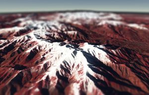
 

3D view of the Canigou on 19-Dec-2017 (with a fancy tiltshift effect)

The Cesium library enables to interact with 3D models of the Earth surface in your browser. In combination with the Sentinel-Hub WMS service, it makes it possible to drape any Sentinel-2 image on a digital elevation model to visualize it in 3D. In his great post about Color Correction with JavaScript, Miha Kadunc of Sinergise illustrated this possibility with Monte Sarmiento in Patagonia. Here, I just re-used his code to make a 3D model with the latest Sentinel-2 image (19-Dec-2017) of one of my favorite mountain, the Canigou.

See and edit code in full screen

The snow season started early this year in the Pyrenees mountains, especially in the French Pyrenees.

Update on 03 April</ins, another example use of Cesium:

Plus d'actualités

BIOMASS, the third launched satellite mission designed at CESBIO !

After SMOS in 2009, and VENµS in 2017, the CESBIO Laboratory is very proud to see its third proposed mission, Biomass, reach orbit. As always, it has been a long journey from the idea, at the beginning of the century, to the selection in 2013 as the seventh Earth Explorer Mission by ESA, to the […]

Sentinel-2 reveals the surface deformation after the 2025 Myanmar earthquake

Sentinel-2 captured several clear-sky images of Myanmar before and after the 28 March 2025 earthquake. The animation below shows a 5-day apart sequence of images captured by Sentinel-2B and Sentinel-2C (10 m resolution) near the epicenter located close to Mandalay. The surface slip due to the earthquake follows the Sagaing Fault, a major fault in […]

Evolution de l’altitude de la ligne de neige au cours des 41 dernières années dans le bassin versant du Vénéon (Oisans)

Pour contribuer à caractériser les conditions hydrométéorologiques lors de la crue torrentielle qui a frappé la Bérarde en juin, j’ai analysé une nouvelle série de cartes d’enneigement qui couvre la période 1984-2024 [1]. Grâce à la profondeur temporelle de cette série, on constate que l’altitude de la ligne de neige dans le bassin versant du […]

Rechercher