S1-Tiling, on demand ortho-rectification of Sentinel-1 images on Sentinel-2 grid

![]() =>
=> ![]() Sentinel-1 is currently the only system to provide SAR images regularly on all lands on the planet. Access to these time series of images opens an extraordinary range of applications.In order to meet the needs of a large number of users, including our needs, we have created an automatic processing chain to generate « Analysis Ready » time series for a very large number of applications. Sentinel-1 data is ortho-rectified on the Sentinel-2 grid to promote joint use of both missions.
Sentinel-1 is currently the only system to provide SAR images regularly on all lands on the planet. Access to these time series of images opens an extraordinary range of applications.In order to meet the needs of a large number of users, including our needs, we have created an automatic processing chain to generate « Analysis Ready » time series for a very large number of applications. Sentinel-1 data is ortho-rectified on the Sentinel-2 grid to promote joint use of both missions.
S1Tiling was developed within the CNES radar service, in collaboration with CESBIO, to generate time series of calibrated, ortho-rectified and filtered Sentinel-1 images on any terrestrial region of the Earth. The tool benefits for the SAR ortho-rectification application from the Orfeo Tool Box. The resulting images are registered to Sentinel-2 optical images, using the same MGRS geographic reference. You will be able to access Sentinel-1 data acquired on Sentinel-2 31TCJ or 11SPC tiles.This Python software, is based on the Orfeo Tool Box (OTB) image processing library, developed by CNES, as well as on the PEPS platform to access the Sentinel-1 data. It can be used on any type of platform, from a large computing cluster to a laptop (the fan will make some noise during processing). It is considerably faster than the ortho-rectification tool in SNAP, and can be easily used in script form. For any questions, please use the gitlab platform, rather than leaving comments to this article.
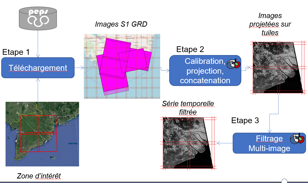
S1Tiling is currently used for many applications, such deforestation detection in the Amazon, monitoring of rice crops in Southeast Asia or monitoring of water stocks in India.In addition, this software is accessible as an on-demand processing service on the French PEPS collaborative ground segment, in order to make it easier for users to use.
Use S1-Tiling within PEPS
If you are allergic to the command line (that’s a pity), you can use the on-demand processing features of PEPS, although it does not include the speckle filter yet. It’s very simple.
- First, connect to PEPS (https://peps.cnes.fr)

- Select the « explore » function
- Query the catalogue to obtain the images you wish to process (don’t forget to mention you want a GRD Sentinel-1 product). For each product that fits your criteria, click on the gearing icon
- go to the processing page (gearing icon, top-right)
- select Sentinel-1 ortho-rectification
- select every product and start processing
- just wait for a while