MAJA now corrects thin cirrus clouds on Landsat-8 and Sentinel-2 images

![]() =>
=> ![]() Thanks to our collaboration with DLR,, who developed the method [1], and with an ESA funding, we added within MAJA a correction for thin cirrus clouds that works for LANDSAT 8 and Sentinel-2. This correction uses the cirrus band at 1.38 µm, which allows to estimate cirrus reflectance, which is then subtracted from the other bands with an empiric factor derived from the images.
Thanks to our collaboration with DLR,, who developed the method [1], and with an ESA funding, we added within MAJA a correction for thin cirrus clouds that works for LANDSAT 8 and Sentinel-2. This correction uses the cirrus band at 1.38 µm, which allows to estimate cirrus reflectance, which is then subtracted from the other bands with an empiric factor derived from the images.
MAJA was made to automatically process large time series, it is therefore not interesting to control visually each image before deciding whether to apply or not cirrus correction. Yet, even if this correction usually provides good results, which sometimes appear magical, it is not perfectly reliable, pfor several reasons :
- some cirrus clouds are too thick to be corrected,
- others are too sharp (the cirrus band does not observe exactly in the same direction as the others, resulting in registration errors for high altitude clouds),
- when the cirrus is removed, its shadow often appears beneath
- the empirical factor can be inaccurate for highly non uniform images
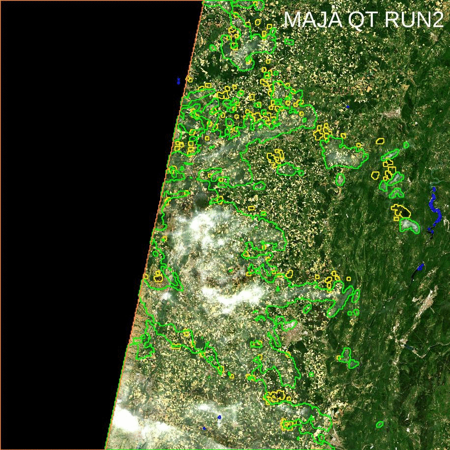
Hence, we have decided to apply the correction only to pixels classified as cirrus clouds, as these pixels are not used by automatic processing. And we had to smooth a little the applied correction along the cloud borders to avoid discontinuities to appear [2]. Because of the unreliability of the method, we advise you to have a look at the image before deciding to use a corrected cirrus pixel in your application. But you can still use almost blindly the pixels not flagged as clouds. There are a few samples of results. The animations below show alternatively MAJA results without (RUN2) and with (RUN3) cirrus correction. You can see that the modifications occur only for pixels where a cloud was detected, within the green contours.

A few other samples for Sentinel-2. On the middle image, a thick cirrus was over corrected.
 |  |  |
A few other examples for Landsat 8:
 |  | |
References
[1] Richter, Rudolf, Xingjuan Wang, Martin Bachmann, and Daniel Schläpfer. « Correction of cirrus effects in Sentinel-2 type of imagery. » International journal of remote sensing 32, no. 10 (2011): 2931-2941.[2] Olivier Hagolle, Mireille Huc, Camille Descardins, Stefan Auer, Rudolf Richter, MAJA Algorithm Theoretical Basis Document, https://doi.org/10.5281/zenodo.1209633