Exploitation combinée de VENµS, Sentinel-2 and Landsat-8 : les bandes spectrales
![]() =>
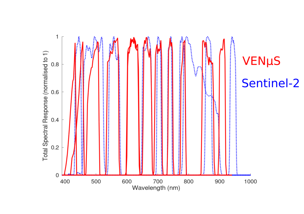
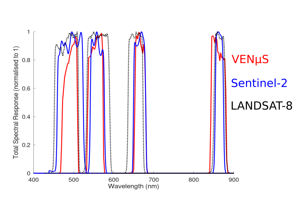
=>![]() L’utilisation combinée des données de VENµS, Sentinel-2 et Landsat-8 peut permettre d’augmenter la probabilité d’obtenir des images sans nuage ou de suivre de manière détaillée des phénomènes à évolution rapide.Afin de faciliter cette combinaison, le tableau ci-dessous présente de manière résumée les correspondances entre les bandes spectrales des instruments. VENµS ne comporte pas de bande spectrale dans le moyen infrarouge.La figure ci-dessous présente les bandes spectrales de VENµS et Sentinel-2 dans le domaine 400 à 1000 nm. Les bandes SWIR de Sentinel-2 ne sont incluses.Le tableau ci-dessous présente les combinaisons de bandes usuellesLa figure ci-après permet d’apprécier le degré de similarité des réponses spectrales de ces bandes usuelles.Les réponses spectrales détaillées de chaque instrument sont disponibles via les pages web suivantes : VENµShttps://www.cesbio.cnrs.fr/multitemp/?page_id=14229SENTINEL-2https://earth.esa.int/web/sentinel/user-guides/sentinel-2-msi/document-library/-/asset_publisher/Wk0TKajiISaR/content/sentinel-2a-spectral-responsesLANDSAThttps://landsat.usgs.gov/spectral-characteristics-viewerhttps://landsat.usgs.gov/landsat/spectral_viewer/bands/Ball_BA_RSR.xlsx
L’utilisation combinée des données de VENµS, Sentinel-2 et Landsat-8 peut permettre d’augmenter la probabilité d’obtenir des images sans nuage ou de suivre de manière détaillée des phénomènes à évolution rapide.Afin de faciliter cette combinaison, le tableau ci-dessous présente de manière résumée les correspondances entre les bandes spectrales des instruments. VENµS ne comporte pas de bande spectrale dans le moyen infrarouge.La figure ci-dessous présente les bandes spectrales de VENµS et Sentinel-2 dans le domaine 400 à 1000 nm. Les bandes SWIR de Sentinel-2 ne sont incluses.Le tableau ci-dessous présente les combinaisons de bandes usuellesLa figure ci-après permet d’apprécier le degré de similarité des réponses spectrales de ces bandes usuelles.Les réponses spectrales détaillées de chaque instrument sont disponibles via les pages web suivantes : VENµShttps://www.cesbio.cnrs.fr/multitemp/?page_id=14229SENTINEL-2https://earth.esa.int/web/sentinel/user-guides/sentinel-2-msi/document-library/-/asset_publisher/Wk0TKajiISaR/content/sentinel-2a-spectral-responsesLANDSAThttps://landsat.usgs.gov/spectral-characteristics-viewerhttps://landsat.usgs.gov/landsat/spectral_viewer/bands/Ball_BA_RSR.xlsx


