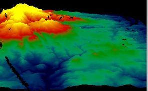
A single VENµS acquisition is sufficient to estimate the terrain elevation of a scene thanks to the so-called « native stereo » technique.
One of the main missions of VENµS, the Franco-Israeli satellite launched in August 2017, is to carry out acquisitions over more than a hundred scientific sites around the world. Its resolution at 5.3 m and the 2-day revisit period of its observations enable improved modelling of phenomena acting on vegetation and continental surfaces. In this context, the generation of DTMs (Digital Terrain Models) would make it possible to monitor changes in soil elevation (altitude of mountainous sites, landslides, etc.).
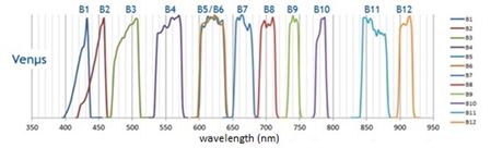
Figure 1: Spectral responses of the bands acquired by VENµS
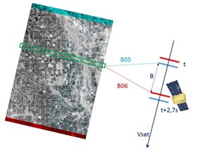
The VENµS camera acquires 12 spectral bands, all different except for the pair (B05/B06) which have almost identical spectral responses (see Figure 1). These two bands being placed at the extremities of the focal plane, the same detail on the ground is thus seen from two different angles (see Figure 2). VENµS therefore has a native stereoscopic capability characterized by a rather low B/H (base-to-high) ratio, equal to 0.025.
Figure 2: Schematic view of the native stereoscopic capability of VENµS. The B05 band looks slightly forward and the B06 band slightly backward.
This B/H ratio is very low (to be compared for example with Pleiades stereo shots which have a B/H ratio of around 0.15). This difference in observation angle is used in particular for the detection of clouds by their altitude for the production of Level 2A products with MAJA. The purpose of the study conducted here was to evaluate the altitude restitution performance obtained from a single VENµS acquisition despite the low B/H ratio.
The techniques implemented during the radiometric and geometric calibration phase of the VENµS satellite allowed to improve the sensors absolute geometry and image Matching. These are two major contributors to stereo performance. In the case of VENµS, the restitution of the satellite’s attitude was rather imprecise, and CNES has implemented a new method to correct these errors, reaching a multiband registration performance of 0.05 pixel.
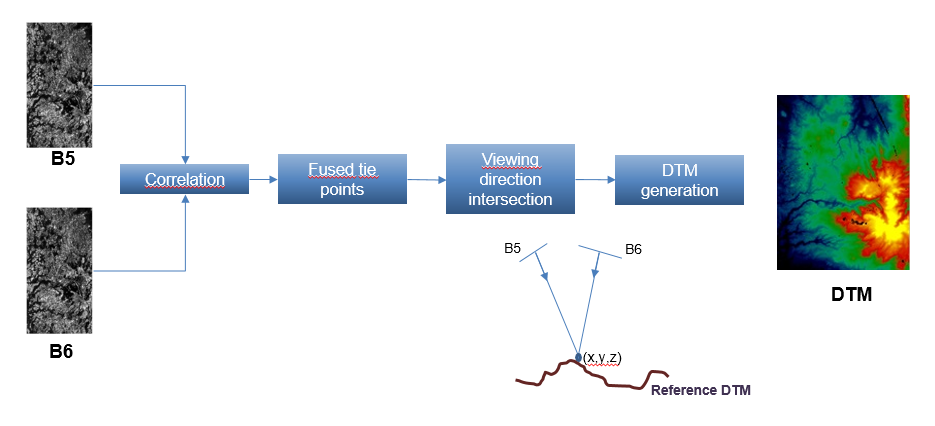
Subsequently, a processing chain (described in Figure 3) was developed to produce VENµS DTMs based on 1) image matching and 2) the intersection of the look directions of the homologous pixels. The quality of the generated DTM is then evaluated by comparison with a reference DTM (SRTM).
Figure 3: Processing chain implemented for the generation of VENµS DTMs
This study showed that the accuracy of altitude restitution obtained is of the order of 8m. These promising results not only open up prospects in the context of scientific studies (e.g. joint analysis with bathymetry, landslides), but may also help to define future missions. For example, if the results of this study are confirmed, a mission with a resolution of 2 m with the same B/H as VENµS (the feasibility of which remains to be demonstrated) could make it possible to obtain DEMs with an altimetric accuracy of 3 m. With such a precision, it is possible to detect the construction or destruction of a building, monitor tree growth, detect logging, or estimate the long-term decrease in glacier heights. This would be very interesting in the preparation of a mission such as Sentinel-HR.
Finally, due to time constraints, we have not yet been able to use multiple observations of the same site every two days to further improve the accuracy of relief estimation.
Nous utilisons des cookies pour vous garantir la meilleure expérience sur notre site web. Si vous continuez à utiliser ce site, nous supposerons que vous en êtes satisfait.