Venµs

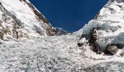
Khumbu icefall in 4D

This video shows all available Venµs images since launch over the Khumbu icefall near Mt Everest (109 images). The images are RGB composites of Level 1C bands 7,4,3 (5 m resolution) that were draped onto the HMA 8m DEM.   How to do that? First download the Venµs images using theia_download.py, extract the region of […]

13.10.2019

[How it works] Can reflectances be greater than 1 ?

=>  Beware, this document contains equations Having written a lot of posts in this blog, twitter or linkedIn, or due to the distribution of products and softwares on Theia or Github, Users of these channels questions per week in one of these channels, which I try to answer, even if not always at once. Many […]

03.09.2019

VENµS monitors the resillience of Bouconne forest to caterpillar defoliation

=> I left you in mid-July with an unbearable suspense: would the Bouconne oak forest, the real lung of the Toulouse conurbation, resist the caterpillar attack of which it was the victim? The gypsy moth is a small butterfly whose voracious caterpillar appreciates oaks. This year, the moth caterpillars have flourished in some areas of […]

09.08.2019

[VENµS] La forêt de Bouconne a résisté à l’attaque à la bombyx

=> Je vous avais laissés à la mi-juillet avec un suspense insoutenable: la forêt de chênes de Bouconne, véritable poumon de l’agglomération de Toulouse, allait-elle résister à l’attaque à la bombyx dont elle était la victime ? Le bombyx disparate est un petit papillon dont la chenille vorace apprécie les chênes, qui cette année a […]

08.08.2019

Combined exploitation of VENμS, Sentinel-2 and Landsat-8: the spectral bands

=> The combined use of VENμS, Sentinel-2 and Landsat-8 data can increase the likelihood of obtaining cloud-free images or may allow detailed tracking of rapidly evolving phenomena. In order to facilitate this combination, the table below summarizes the correspondences between the spectral bands of the instruments. VENμS does not have a spectral band in the […]

09.05.2019

Exploitation combinée de VENµS, Sentinel-2 and Landsat-8 : les bandes spectrales

=>L’utilisation combinée des données de VENµS, Sentinel-2 et Landsat-8 peut permettre d’augmenter la probabilité d’obtenir des images sans nuage ou de suivre de manière détaillée des phénomènes à évolution rapide.Afin de faciliter cette combinaison, le tableau ci-dessous présente de manière résumée les correspondances entre les bandes spectrales des instruments. VENµS ne comporte pas de bande […]

VENμS: there is still snow in the Pyrenees

From Mont Valier to la Roca Foradada, on April 30 (left) and May 6th, 2019(right)   3D View : download KMZ files for KMZ pour Google Earth :April 30, 2019May 6 2019

07.05.2019

VENµS : il reste de la neige dans les Pyrénées

Du Mont Valier à la Roca Foradada, le 30 avril  (à gauche) et le 6 mai 2019 (à droite)   Visualisation 3D Télécharger un fichier KMZ pour Google Earth :30 avril 20196 mai 2019

Summer in the Southern Alps by Venµs

Venµs is a French-Israeli satellite mission which captures high resolution multi-spectral images every two days over selected sites. The Theia land data center is kind enough to provide L2A images (bottom-of-atmosphere), which can be easily downloaded by batch (see this tutorial). Here I selected all the images of a site near Mount Cook in the […]

07.03.2019

Rechercher