Satellite Missions

Mapping the Glacier Bay landslide using Sentinel-1 and Sentinel-2

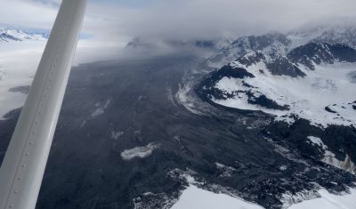
Dave Petley wrote a nice article in the AGU’s Landslide blog about a massive landslide in Glacier Bay, Alaska. This huge avalanche of debris was spotted by a local pilot Paul Swanstrom on June 28. When Paul was above it, « dust was still flying ». Later, based on earthquake records in Alaska, the experts figured out […]

19.07.2016

New version of fully automatic land cover map of France for 2014 from LANDSAT8

=> Over the last months, we worked a lot on our method for Land Cover map production. Three main topics (1) were studied with Arthur Vincent and David Morin at CESBIO : porting and validating the iota2 processor on the CNES High Performance Computing facilities (HPC); enhancing the method for reference data preparation. Reference data […]

09.07.2016

Nouvelle version des produits d’occupation des sols OSO sur la France en 2014

=>Nous avons beaucoup travaillé sur la procédure de génération des cartes d’occupation des sols ces derniers mois. Trois axes principaux1 ont été abordés par Arthur Vincent et David Morin au Cesbio : Le portage et la validation de la chaîne de traitement iota2 sur l’infrastructure de calcul à haute performance (HPC) du Cnes. L’amélioration de la […]

08.07.2016

Téléchargez des exemples de produits de niveau 2A Sentinel-2 produits par THEIA

=> Exemples de produits La validation du segment sol MUSCATE, au sein du du pole de données THEIA, est en cours, et nous pouvons dès à présent four fournir des exemples de produits pour vous permettre de vous familiariser avec leur format, et pour que vous puissiez préparer vos outils de lecture. Les produits que […]

05.07.2016

Download some samples of THEIA L2A products for S2A

=>  Sample products The validation of the operational MUSCATE ground segment, within the THEIA Land Data Center is going on, and we are starting to deliver a few sample products so that you may  start to prepare your softwares to use them. The sample products were acquired by Sentinel-2 over Provence and the Alps, during the […]

First Sentinel-2 monthly cloud free syntheses from the Sen2Agri system

=>  The Sen2Agri System, funded by ESA, is now on its pre-operational phase. It has just completed its first mass production and in this context, we just obtained our first Level 3A syntheses obtained with Sentinel-2A. Level 3A products are monthly syntheses of non cloudy pixels. Syntheses The monthly syntheses are produced by the Sen2Agri system. They use […]

30.06.2016

Les premières synthèses mensuelles Sentinel-2 issues du système Sen2Agri

=> Le système Sen2Agri, financé par l’ESA, est en phase de validation pré-opérationnelle. Il vient donc de réaliser ses premières productions de masse. Dans ce cadre, nous venons d’obtenir, avec Sentinel-2A, nos premières synthèses de Niveau 3A, c’est à dire des synthèses mensuelles des réflectances de surface des pixels non nuageux. Synthèses Les synthèses mensuelles sont produites par le […]

28.06.2016

SPOT(Take5) talks and posters at Living Planet Symposium

The SPOT(Take5) project had a one day session at the living planet symposium ! If it looked nice when we decided it, it turned out that it was not a true good idea. Most of the LPS 2016 sessions were thematic sessions (forest, agriculture, coasts, inland waters…), while the SPOT (Take5) sessions were jumping from […]

22.06.2016

Mapping flooded areas using Sentinel-1 in Google Earth Engine

Exceptional rainfall in May caused heavy flooding in the Paris region. Newspapers and TVs reported that the Seine flood forced the Louvre staff to move away from rising waters the art pieces that were stored in their cellar. But they did not tell you that about 50 km east of the Louvre museum, the flood […]

10.06.2016

Rechercher