The Sentinel-2 contest – Grand jeu-concours !
Play to win the prize: ONE YEAR OF FREE SUBSCRIPTION to the blog « Séries Temporelles »! Jouez pour gagner : UN AN D’ABONNEMENT GRATUIT au blog « Séries Temporelles » !
Play to win the prize: ONE YEAR OF FREE SUBSCRIPTION to the blog « Séries Temporelles »! Jouez pour gagner : UN AN D’ABONNEMENT GRATUIT au blog « Séries Temporelles » !
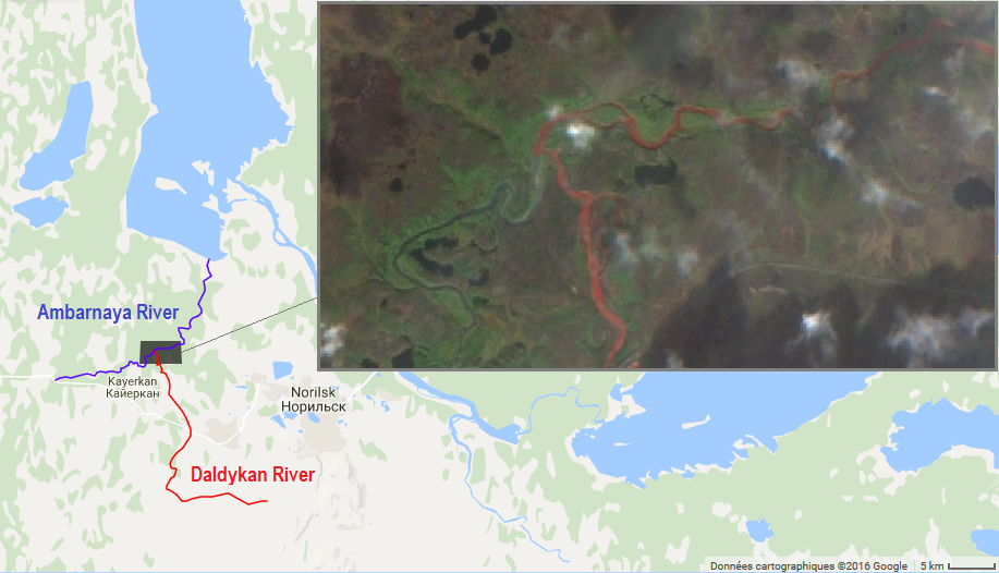
The Daldykan River is a tributary of the Ambarnaya River, which feeds the Lake Pyasino in Siberia (738 km²). According to Wikipedia in English Lake Pyasino « is almost completely devoid of fish ». However, Wikipedia in French states that « Il est très poissonneux » (full of fish).

=>The production of Level2A Sentinel-2A data by Theia is a little delayed, but we will still deliver, before the end of the month, the level 2A products acquired over France by Sentinel-2A so far. The production of the other selected sites, and the real time production will start a little later. It is not a piece […]

=>La production des données de N2A de Sentinel-2 par Theia a pris du retard, mais nous allons cependant fournir, dès la fin septembre, les produits de niveau 2A correspondant aux données acquises sur la France par Sentinel-2. La production des autres sites sélectionnés, et celle en temps réel démarreront un peu plus tard. Ce n’est pas […]

Wildfires were raging in California this summer. Let’s see if we can spot some of them in Sentinel-2A images with the new Sentinel-Playground by Sinergise. The combination of the SWIR and NIR bands of Sentinel-2 or Landsat enables to produce accurate maps of burnt areas. The SWIR band is sensitive to the water content in the […]
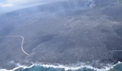
=> Le volcan Kilauea à Hawaï est un des plus actifs au monde. Cela fait déjà plus de trente ans qu’il est entré en éruption, mais il a fait les gros titres récemment car ses coulées ont atteint l’océan Pacifique, agrandissant le territoire hawaïen de deux hectares d’un coup ! Voilà une technique efficace pour […]
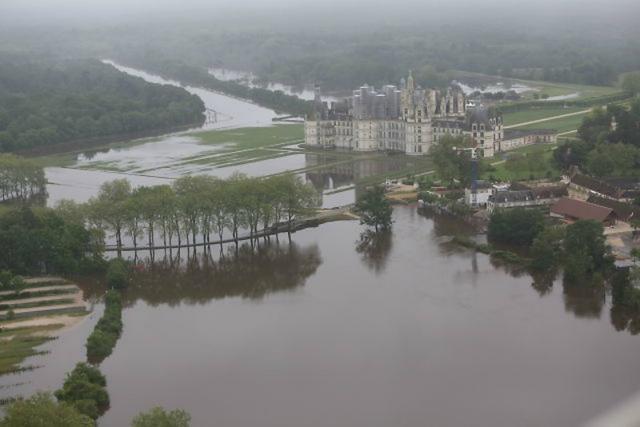
Short after working with Simon on the script for the article about the mapping of flooded areas, I wanted to be sure that our short script was realistic. I had some time to loose at the airport, so, after finding a wifi connection, I looked for pictures of the flooded areas of the north of […]
=> Kilauea Volcano in the largest active volcano in Hawaii and one of the most active on Earth. It has been erupting for over 30 years now but hit the headlines recently because a large lava flow traveled up to the ocean, adding 2 brand new hectares to the Hawaiian Islands.
=>C’est avec nostalgie que je vous fais part de la fin d’exploitation du satellite Formosat 2, dont un certain nombre de composants sont tombés en panne récemment, après 12 ans de fonctionnement (8 de plus que prévu). Au moment de son lancement, nous cherchions des données nous permettant de simuler les caractéristiques du satellite VENµS (prévu pour […]