Satellite Missions

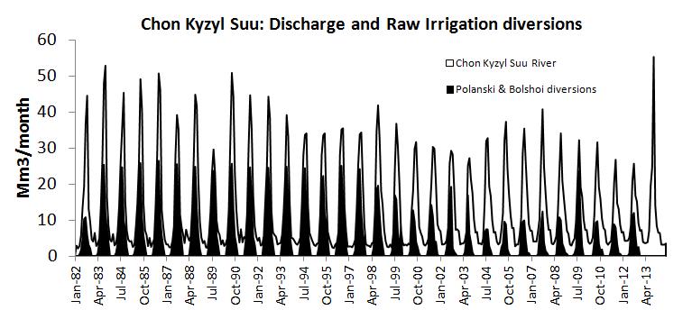
Monthly cloud free syntheses merging Sentinel-2 and Landsat 8

To compute a cloud free synthesis of surface reflectances every month, a good repetitivity of observations is necessary. The weighted average method we developed at CESBIO, and which will be part of ESA’s sen2agri system was coded by Cosmin Udroiu at CS Romania. It was meant to work with both Sentinel-2 sensors and an observation every […]

07.11.2016

High spatial and temporal resolution optical remote sensing data to estimate maize biomass and yield

=> Climate variability has a strong impact on maize yield. For example, the strong drought that occurred in 2016 led to lower yields across France, even for irrigated fields. Yield estimates have a significant strategic and economic importance. High spatial and temporal resolution remote sensing data are a valuable tool for providing yield estimates at […]

17.10.2016

La télédétection optique à haute résolution spatiale et temporelle au service de l’estimation de la biomasse et du rendement du maïs

=> La variabilité climatique a un fort impact sur le rendement du maïs. Par exemple, les fortes sécheresses de 2016 ont conduit, même pour les parcelles irriguées, à une baisse des rendements à travers la France. Les estimations des rendements présentent un enjeu stratégique et économique important. La télédétection à haute résolution spatiale et temporelle […]

Patagonian skies are not cloudy anymore

« The most usual weather in these latitudes is a fresh wind between north west and south west with a cloudy overcast sky » – Phillip Parker King, Sailing Directions for the Coasts of Eastern and Western Patagonia (1832). Patagonia is a beautiful place to visit but campers know that the weather is extremely variable and the […]

08.10.2016

Irrigated crop maps for a better water management in agriculture

=>In a previous post, i have briefly presented: To classify irrigated farmland, within the growing period and at the scale of a territory, we focused on the use of optical remote sensing images. In the lines below, I will introduce the work to generate maps of irrigated crops usin Landsat-8 time series level 2A made […]

06.10.2016

An overview of irrigation evolution in Central Asia with Landsat

In Central Asia former soviet republics, pre-independence water allocation and irrigation system infrastructure were well maintained and operated with massive funding from the central government of the Former Soviet Union. Since independence, the situation has changed dramatically politically, institutionally and technically. Political transition from a planned to a market economy has introduced ‘new’ concepts such […]

04.10.2016

THEIA releases Sentinel-2 L2A data over France

=>A first large scale data set of Sentinel-2 level 2A products was just issued by CNES. It contains all the data acquired by Sentinel-2 over France, from December 1st, 2015 until end of August. It was produced with MACCS on MUSCATE ground segment. The data can be downloaded from :  In case all DNS are not […]

30.09.2016

Theia diffuse les données de niveau 2A de Sentinel-2 sur la France

  =>Le CNES vient de mettre en ligne un premier lot de produits Sentinel-2 de niveau 2A. Il contient toutes les données acquises par Sentinel-2 au dessus de la France, depuis décembre 2015 jusqu’à fin août 2016. Les données ont été produites par la chaîne MACCS sur le nouveau centre de traitement MUSCATE, dont il […]

Scientists anticipate another glacier collapse in Tibet from satellite data

The giant ice avalanche that occurred in Tibet on 17 July 2016 and killed 9 people [1] urged scientists to scrutinize every available data to understand what caused such a glacier collapse. In doing so, they witnessed in near real time the ongoing collapse of a second glacier.

29.09.2016

Rechercher