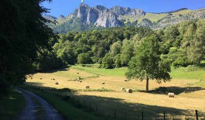
Languages

Debris flow in the Ishkoman Valley

In July 2018, the Pamir Times has reported that a lake formed due to a debris flow in the Ishkoman Valley, Pakistan. This event caused the destruction of dozens of housed in Badswat and Bilhanz villages. The flood debris running down the slope hit the mountain on the opposite side, and formed a barrier, blocking […]

23.06.2020

Benefits of SAR for forest loss alert detection in the tropics

The tropical forest is an important carbon sink which also hosts high biodiversity. Monitoring forest loss is therefore a major issue which requires efficient and accurate tools. In fact, the major challenge is to detect forest loss as precisely and quickly as possible, despite cloud cover which limits the availability of usable optical satellite imagery. […]

05.06.2020

Chaos theory, Rössler cake and satellite remote sensing

Chaos theory, Rössler cake and satellite remote sensing A chaotic attractor was obtained from satellite remote sensing data for the first time in 2011 giving a strong argument for chaos in real environment. This result has a special sound today May 20th 2020, since it is the 80th birthday of Otto E. Rössler — one […]

21.05.2020

Towards a composite of the most recent clear-sky observations from the Theia Snow collection

We are thinking of a new « live » product which would allow anyone to display the most recent snow observations from Sentinel-2 in a web browser. This service would simply display a composite of the latest Theia Snow products over a given time window (e.g. the past 20 days). This can be easily coded thanks to […]

20.05.2020

Détection de la neige sur les routes avec Sentinel-2

France Bleu nous signale une impressionnante avalanche en Savoie près du Col du Glandon qui bloque la route Départementale 927. Les cartes d’enneigement distribuées par Theia permettent d’évaluer la présence de neige sur les routes de montagne grâce à leur haute résolution (pixel de 20 m). Une carte qui date du 09 mai (soit deux […]

12.05.2020

Trouvez la neige à moins de 100 km de chez vous !

Voici un outil qui permet de trouver de la neige à moins de 100 km de chez vous ou dans votre département ! Cette app utilise les cartes de neige journalières produites par la Nasa à partir du capteur Modis sur le satellite Terra (MOD10A1.006). L’observation non-nuageuse la plus récente dans les dix dernières cartes […]

08.05.2020

Bulletin GPoM-epidemiologic

The epidemic of Covid-19 and its bulletins In this post, a brief analysis of the epidemic of Coronavirus Covid-19 that broke out in Wuhan (China) on last December 2019 is sketched. More specifically, this analysis originally focused on the period January 31st to February 27th and was then extended by Bulletins. Bulletins Last Bulletin: Bulletin […]

29.04.2020

Lucky Sentinel-2 still can visit Italia, Spain and Portugal

That’s unfair ! Sentinel-2 is a lucky satellite who still can visit Spain, Italy or Portugal every 5th day, while we are locked at home. Thanks to the hard work and good organisation at ESA (for the Level-1 products) and CNES (for the advanced L2A and L3A products), I have been able to generate mosaics […]

22.04.2020

Estimate terrain elevation from a single pass of VENµS satellite and monitor its evolution over time

A single VENµS acquisition is sufficient to estimate the terrain elevation of a scene thanks to the so-called « native stereo » technique. One of the main missions of VENµS, the Franco-Israeli satellite launched in August 2017, is to carry out acquisitions over more than a hundred scientific sites around the world. Its resolution at 5.3 m […]

18.04.2020

Rechercher