In English

WASP source and executable are now openly available

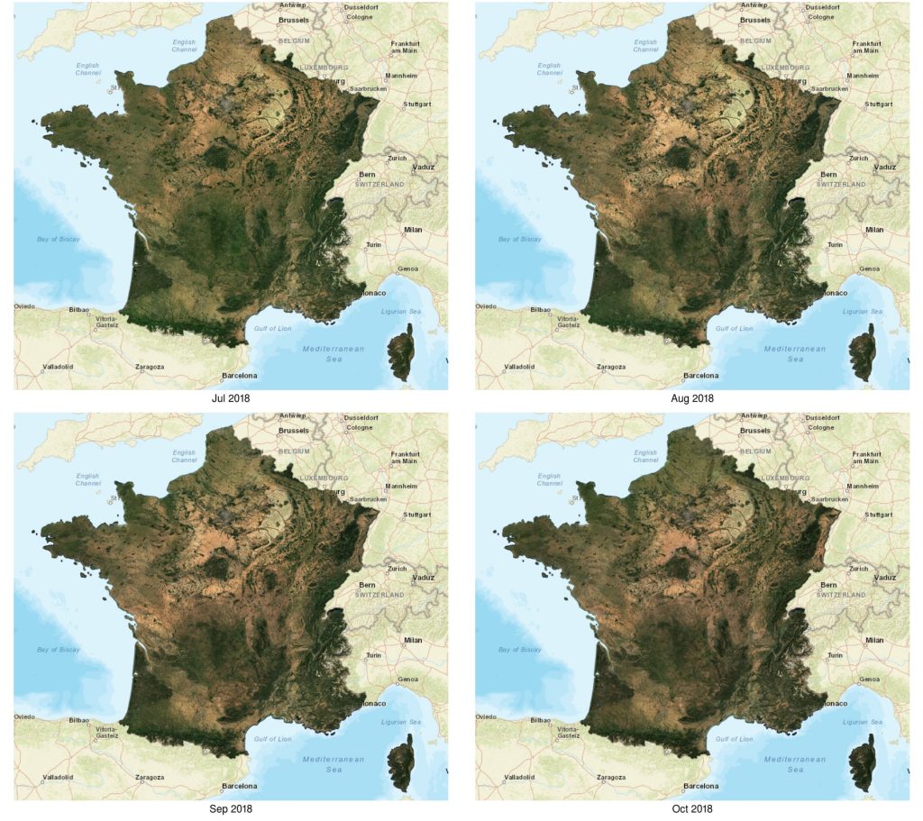
WASP (Weighted Average Synthesis Processor) is the tool we use to compute the nice (mostly) cloud free syntheses of Sentinel-2 surface reflectances, as shown in the images below. A full resolution viewer is also available in this post, or you may also download the products you can download from Theia. As promised (but it took […]

06.04.2019

Satellite detection by satellite

=>  Airplanes largely disrupt our remote sensing images, because of the ice contrails they leave behind them, which often turn into cloud cover. We had to set up a method for detecting and correcting aircraft contrails. LANDSAT 8 image acquired over Paris on 14/04/2013. On the left, RGB color composition, on the right, image of […]

01.04.2019

Flying over Antarctica in 1968

The Polar Geospatial Center has put online a nice web mapping interface to browse and download trimetrogon aerial (TMA) photography of Antarctica [1]. The trimetrogon was a system of three cameras which captured three photographs at the same time, one vertical and two high oblique. I made the animation [2] below with the left photos […]

22.03.2019

Rain-on-snow flood in Nebraska

Several areas in Nebraska experienced record flooding this past week.

18.03.2019

[MUSCATE news] back to nominal production

Good news, MUSCATE is back to nominal production !The source of the issue (archiving the produced data) is not solved yet, but it has been mitigated to allow to come back to real time production. A big thanks to the exploitation team and to the CNES computing center who gave us extra disk space to […]

14.03.2019

Snow melt patterns in Andorra in February 2019

The animation below shows the evolution of the snow cover area near Andorra la Vella, the highest capital city in Europe and a popular ski resort, from 15-Feb-2019 to 27-Feb-2019.

10.03.2019

[MUSCATE news] Slow production / Production ralentie

Following the installation of MUSCATE version 2.5, the production has resumed, but very slowly. It seems to be hampered by the archiving of data, which takes too much time. This causes traffic jams in the scheduler, an the team has no other solution right now than reducing the throughput of MUSCATE.We hope to solve this […]

09.03.2019

Summer in the Southern Alps by Venµs

Venµs is a French-Israeli satellite mission which captures high resolution multi-spectral images every two days over selected sites. The Theia land data center is kind enough to provide L2A images (bottom-of-atmosphere), which can be easily downloaded by batch (see this tutorial). Here I selected all the images of a site near Mount Cook in the […]

07.03.2019

Sentinel-2 Level 3A products : syntheses or composites ?

=> For the past few months, Copernicus has been distributing Level 3A products for the Sentinel-2 mission as part of the S2GM (Sentinel-2 Global Mosaics) . This ambitious project aims to provide monthly, quarterly or annual Level 3A products worldwide. The user defines his zone and period of interest and orders the product. The web site […]

03.03.2019

Rechercher