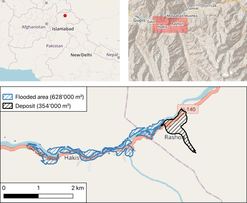
landslide

How to use on demand InSAR to analyse the Joshimath landslide

International news media reported that the Joshimath city in north India (Uttarakhand) was « sinking » due to a slow landslide. In January, many houses had developed major cracks on the walls and 145 families were temporarily moved. The Indian space agency published a map of the ground deformation obtained by SAR interferometry using Sentinel-1 data. Although […]

21.01.2023

Pléiades images of the Uttarakhand disaster

Update 17 June 2021: these images were used in a study published in Science by Shugar et al. (2021) A massive rock and ice avalanche caused the 2021 disaster at Chamoli, Indian Himalaya, doi:10.1126/science.abh4455. The Indian Space Agency (ISRO) activated the International Charter « Space and Major Disasters » to image the area of the disater in […]

09.02.2021

Using PEPS to compute the ground surface displacement after the Palu earthquake

The 7.5 magnitude Palu earthquake in 2018 was a disaster that left 2,081 people dead, 1,309 missing and 206,494 displaced. An impressive surface slip associated with the earthquake was visible in optical satellite imagery like Sentinel-2. I used this case to test the new tool that has been made availabe by the PEPS team (https://peps.cnes.fr/). This tool enables […]

14.10.2020

My remote sensing analyses on Twitter. Part 2: landslides

I started to look at landslides in satellite images when I saw this tweet by @RemotePixel: July 11th 2016 Sentinel-2 Image over Glacier Bay, AK massive landslide! pic.twitter.com/pTnHQ7el8G — Remote Pixel (@RemotePixel) July 14, 2016 Like floods, landslides can be quickly identified using a before/after image comparison. In the case of the Glacier Bay landslide […]

20.01.2020

Sentinel-2 + OpenStreetMap = ♡

You may have heard about the tailings dam collapse at Feijão mine in Brumadinho, Brazil. The disaster occurred two days ago on Jan 25 and at least 58 people were found dead, while 300 are still missing. A Sentinel-2 acquisition was planned for today, therefore tonight I checked the EO Browser to see if the […]

27.01.2019

Anak Krakatau before and after the December 2018 eruption

Anak Krakatau (Indonesia) erupted on 22 December 2018. During the eruption the collapse of the volcano summit triggered a tsunami in Sunda Strait causing a death toll of 437. The first post-event clear-sky image was finally acquired by Sentinel-2 today on 13 Jan 2019 (after 10 cloudy acquisitions). Here is an image comparison of the […]

13.01.2019

Sentinel-2 captured the fault line through Palu, Indonesia

On Sep 28 a 7.5 magnitude earthquake struck the city of Palu, in Sulawesi Indonesia. The quake was followed by a tsunami. The animation below shows two Sentinel-2 images before and after the earthquake in Palu. If you look closely you can see the horizontal displacement due to the fault movement through the city. It […]

02.10.2018

Dozens of landslides after the 2018 Hokkaido earthquake

An earthquake with magnitude 6.7 occurred on 06 Sep 2018 in Hokkaido, Japan, killing at least 17 people and leaving nearly 3 million households in Hokkaido without electricity. The quake came two days after typhoon Jebi, « the strongest storm of 25 years« .  Below is an image comparison near Atsuma dam lake in the south of Hokkaido, […]

17.09.2018

Rechercher