Landsat

An overview of irrigation evolution in Central Asia with Landsat

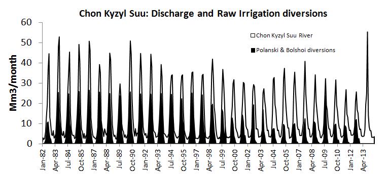
In Central Asia former soviet republics, pre-independence water allocation and irrigation system infrastructure were well maintained and operated with massive funding from the central government of the Former Soviet Union. Since independence, the situation has changed dramatically politically, institutionally and technically. Political transition from a planned to a market economy has introduced ‘new’ concepts such […]

04.10.2016

Theia’s Landsat data are moving

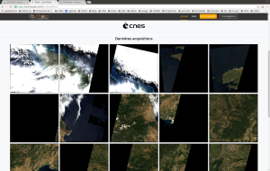
=> It is true that many of us can be moved by the Landsat L2A data produced by THEIA, but this time, the data were literally moved. The presently used downloading site http://theia.cnes.fr is being prepared to host Sentinel-2A data produced by the operational MUSCATE ground segment, and meanwhile, the prototype center goes on producing LANDSAT […]

14.09.2016

Les données LANDSAT de THEIA déménagent

=>Beaucoup d’utilisateurs nous l’ont dit, « elles déménagent vos données », mais cette fois, c’est au sens propre. En effet, le site de téléchargement actuel http://theia.cnes.fr se prépare à accueillir les données sentinel-2 produites par le centre de production MUSCATE opérationnel,. Pendant ce temps, le centre prototype continue à traiter les données LANDSAT sur la France, mais […]

Sentinel-2 et Landsat-8 font équipe pour suivre la coulée de lave du volcan Kilauea

=> Le volcan Kilauea à Hawaï est un des plus actifs au monde. Cela fait déjà plus de trente ans qu’il est entré en éruption, mais il a fait les gros titres récemment car ses coulées ont atteint l’océan Pacifique, agrandissant le territoire hawaïen de deux hectares d’un coup ! Voilà une technique efficace pour […]

04.09.2016

Sentinel-2A and Landsat-8 team up to track Kilauea Volcano’s lava flow

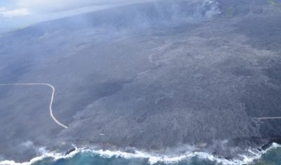
=> Kilauea Volcano in the largest active volcano in Hawaii and one of the most active on Earth. It has been erupting for over 30 years now but hit the headlines recently because a large lava flow traveled up to the ocean, adding 2 brand new hectares to the Hawaiian Islands.

01.09.2016

Sentinel-2A (and Landsat-8) capture a giant ice avalanche in Tibet

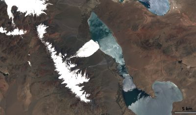
After reading my previous post about the Rutog ice avalanche, my distinguished colleagues Antoine R. and Olivier H. challenged me to look for a pre-event image to better highlight the avalanche area. The closest clear-sky image that I could find is a Landsat-8 image that was acquired on June 24 (23 days before the slide).

25.08.2016

The iota2 Land cover processor has processed some Sentinel-2 data

=> You already heard about iota2 processor, and you must know that it can process LANDSAT 8 time series et deliver land cover maps for whole countries. These las days, Arthur Vincent completed the code that allows processing Sentinel-2 time series. Even if atmospherically corrected Sentinel-2 data are not yet available above the whole France, we used  the […]

03.08.2016

La chaîne d’occupation des sols iota2 sait maintenant traiter Sentinel-2

=>Vous connaissez déjà la chaîne iota2 et vous savez qu’elle sait traiter les séries temporelles Landsat8 et générer des cartes d’occupation des sols. Ces derniers jours, Arthur Vincent a terminé le code permettant d’utiliser les séries temporelles Sentinel-2. Même si nous n’avons pas encore des séries Sentinel-2 sur toute la France (mais elles devraient arriver bientôt), nous […]

01.08.2016

New version of fully automatic land cover map of France for 2014 from LANDSAT8

=> Over the last months, we worked a lot on our method for Land Cover map production. Three main topics (1) were studied with Arthur Vincent and David Morin at CESBIO : porting and validating the iota2 processor on the CNES High Performance Computing facilities (HPC); enhancing the method for reference data preparation. Reference data […]

09.07.2016

Rechercher