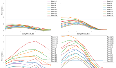
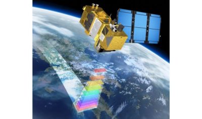
In English

[Directional effects] simple BRDF normalization

Introduction To perform a correction of directional effect, directional models are required. A large number of directional models have been developed, such as the ones of Roujean [1] or Ross-Li [2], that try to reproduce the directional variations as a function of viewing angles and solar angles, with a rather good accuracy for most types […]

07.07.2020

Debris flow in the Ishkoman Valley

In July 2018, the Pamir Times has reported that a lake formed due to a debris flow in the Ishkoman Valley, Pakistan. This event caused the destruction of dozens of housed in Badswat and Bilhanz villages. The flood debris running down the slope hit the mountain on the opposite side, and formed a barrier, blocking […]

23.06.2020

Benefits of SAR for forest loss alert detection in the tropics

The tropical forest is an important carbon sink which also hosts high biodiversity. Monitoring forest loss is therefore a major issue which requires efficient and accurate tools. In fact, the major challenge is to detect forest loss as precisely and quickly as possible, despite cloud cover which limits the availability of usable optical satellite imagery. […]

05.06.2020

Chaos theory, Rössler cake and satellite remote sensing

Chaos theory, Rössler cake and satellite remote sensing A chaotic attractor was obtained from satellite remote sensing data for the first time in 2011 giving a strong argument for chaos in real environment. This result has a special sound today May 20th 2020, since it is the 80th birthday of Otto E. Rössler — one […]

21.05.2020

Towards a composite of the most recent clear-sky observations from the Theia Snow collection

We are thinking of a new « live » product which would allow anyone to display the most recent snow observations from Sentinel-2 in a web browser. This service would simply display a composite of the latest Theia Snow products over a given time window (e.g. the past 20 days). This can be easily coded thanks to […]

20.05.2020

Bulletin GPoM-epidemiologic

The epidemic of Covid-19 and its bulletins In this post, a brief analysis of the epidemic of Coronavirus Covid-19 that broke out in Wuhan (China) on last December 2019 is sketched. More specifically, this analysis originally focused on the period January 31st to February 27th and was then extended by Bulletins. Bulletins Last Bulletin: Bulletin […]

29.04.2020

Lucky Sentinel-2 still can visit Italia, Spain and Portugal

That’s unfair ! Sentinel-2 is a lucky satellite who still can visit Spain, Italy or Portugal every 5th day, while we are locked at home. Thanks to the hard work and good organisation at ESA (for the Level-1 products) and CNES (for the advanced L2A and L3A products), I have been able to generate mosaics […]

22.04.2020

Estimate terrain elevation from a single pass of VENµS satellite and monitor its evolution over time

A single VENµS acquisition is sufficient to estimate the terrain elevation of a scene thanks to the so-called « native stereo » technique. One of the main missions of VENµS, the Franco-Israeli satellite launched in August 2017, is to carry out acquisitions over more than a hundred scientific sites around the world. Its resolution at 5.3 m […]

18.04.2020

A new method from CNES to improve VENµS spectral band registration

=> A new attitude estimation method has been developed for the VENµS satellite, based solely on image content. The registration quality can thus be improved by a factor of 10, paving the way for new applications. Since its launch in August 2018, the Franco-Israeli Venµs pushbroom satellite has been affected by attitude restitution noise that […]

Rechercher