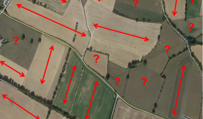
Applications

How to use on demand InSAR to analyse the Joshimath landslide

International news media reported that the Joshimath city in north India (Uttarakhand) was « sinking » due to a slow landslide. In January, many houses had developed major cracks on the walls and 145 families were temporarily moved. The Indian space agency published a map of the ground deformation obtained by SAR interferometry using Sentinel-1 data. Although […]

21.01.2023

Extent of the Alps snow cover in January 2023 (before the storm)

In early January 2023 the snow cover area in the Alps was lower than the 30 years minimum. The snow cover area in January 2023 was lower than the snow cover area last year at the same period. This caused the publication of a lot of depressing ski resorts photographs. But the ongoing snowfalls in […]

18.01.2023

A 10 m resolution land cover map of Sahel with iota2

iota2 is the large scale mapping software developed at CESBIO. iota2 takes high resolution satellite image time series (SITS), usually Sentinel (1 and 2) or Landsat, and produces maps over large areas. Maps of most usual variables of interest in remote sensing can be produced, since iota2 can compute user-defined functions at the pixel level, […]

09.01.2023

Iceberg B-22A on the go

B-22A is the largest iceberg in the Amundsen Sea, Antarctica (50 times Manhattan land area). It broke off from Thwaites Glacier’s tongue and remained grounded for 20 years.. But now it’s on the go, as shown by this animation I made from Sentinel-1 SAR images (about 1 per month since June 2015, total 75 frames): […]

08.01.2023

Manque de neige et de données dans les Pyrénées Orientales

J’étais hier dans la maison du parc naturel régional des Pyrénées Catalanes pour discuter des possibilités offertes par la télédétection pour suivre le manteau neigeux. Les participants à la réunion représentaient bien les différents usages de l’eau dans ce territoire (milieux naturels, agriculture, eau municipale, hydro-électricité, domaines skiables). Tous ont exprimé le besoin de mieux […]

06.01.2023

Feedback on hydrological monitoring of Telangana region in India using remote sensing

=> Claire Pascal, PhD student at CESBIO, under the supervision of Olivier Merlin (CNRS researcher) and Sylvain Ferrant (IRD researcher) brilliantly defended her thesis on the monitoring of water resources by satellite on November 18. Claire’s work focused on the Telangana region of India where rainfed cotton and flooded rice farming dominate. The region has […]

01.12.2022

Retour d’expérience sur le suivi hydrologique d’une région Indienne par télédétection

=> Claire Pascal, doctorante au CESBIO, sous la direction d’Olivier Merlin (chercheur CNRS) et co-dirigée par Sylvain Ferrant (chercheur IRD) a brillamment soutenu sa thèse sur le suivi des ressources en eau par satellite le 18 novembre. Les travaux de Claire se sont focalisés sur la région du Telangana en Inde où la culture non […]

10.11.2022

Campagne expérimentale dans des conditions estivales extrêmes sur Auradé !

Campagne expérimentale dans des conditions estivales extrêmes sur Auradé ! Entre orage (apport de 40 mm de pluie), puis sècheresse et canicule (40°C), les variations de l’état hydrique du sol de la parcelle flux ICOS d’Auradé furent optimales entre fin juin et mi-juillet 2022 pour accueillir et mener la campagne expérimentale Pré-HiDRATE (integrating High resolution Data […]

16.09.2022

Iota2 latest release – Deep Learning at the menu

‎ Table of Contents 1. New iota2 release 2. Classification using deep learning 2.1. Material 2.1.1. Satellite image time series 2.1.2. Preparation of the ground truth data 2.1.2.1. Sub data set 2.1.2.2. Clean the ground truth vector file 2.2. Configuration of iota2 2.2.1. Config and ressources files 2.2.2. Iteration over the different sub ground truth […]

Rechercher