snow-ice

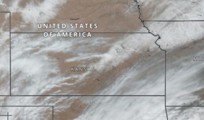
Watching snow melt at 10 minute intervals from space

This is something new to me… The Geostationary Operational Environmental Satellites (GOES) capture images every 10 minutes at 1 km resolution over America… Such imagery makes it possible to watch the quick melt of a thin snow cover over the US Great Plains during a single day. Sub-daily monitoring of the snow cover at such […]

In English

Lowest snow cover area in the Alps since 2001

On March 2nd, the snow cover area in the Alps has reached its lowest value since 2001. Only 43% of the alpine range was covered by snow (about 82’000 square kilometers), whereas the average is 63% on the same day over the period 2001-2021. The deficit in the number of snow covered days (map below, […]

In English

MAJA 4.5 is now available and compliant with the new Sentinel-2 L1C format

=> UPDATE (Feb 14th 21): the version 4.5.3 is now released and fixes a few minor issues found while testing the first time series of the new L1C format, please upgrade to Maja 4.5.3 ! Following the announcement by ESA of a major product format upgrade for Sentinel-2 by early January 2022, the development team […]

En Français

Les Pyrénées ont fait le dry January

La surface enneigée n’a jamais été aussi basse un 6 février depuis 2001. Elle était de 6 100 kilomètres carrés, alors que la moyenne à cette date est 13 900 kilomètres carrés. Cette situation résulte d’une longue période sèche et ensoleillée qui a commencé le 10 janvier avec l’installation d’une situation anticyclonique.     La […]

CESBIO

TropiSCO scores against deforestation

=> The TropiSCO project aims at providing maps of tree cover loss in dense tropical forests using Sentinel-1 satellite images, starting in 2018 and in near real time. The maps will soon be publicly available via a webGIS platform and updated weekly at 10m resolution. Forest loss as small as 0.1 hectare will be detected […]

CESBIO

TropiSCO secoue la déforestation

=> L’objectif du projet TropiSCO est de fournir des cartes de suivi des pertes de couverture forestière dans les forêts denses tropicales avec les images des satellites Sentinel-1, à partir de 2018 et en continu. Les cartes seront bientôt accessibles publiquement via une plateforme webGIS et mises à jour toutes les semaines, à 10m de […]

Composite (3A)

Neige et crues dans les Pyrénées entre novembre 2021 et janvier 2022

Le manteau neigeux s’est constitué rapidement dans les Pyrénées suite à plusieurs chutes de neige abondantes entre le 23 novembre et le 10 décembre. Après ce début de saison tonitruant, la surface enneigée a rapidement décliné pour atteindre une valeur plutôt basse au début de l’année 2022. Cette fonte rapide est la conséquence des températures […]

In English

Sentinel-1b is currently out of work

New Update : 1.5 month after, ESA has not yet been able to resume operations with Sentinel-1. The work is now concentrating on understanding the cause of the breakdown, to determine if some modifications are necessary before launching Sentinel1C, not before the end of 2022. Update : 1 week after, attemps to resume exploitation of […]

3D

CO3D: CNES Very High Resolution mission dedicated to 3D, to produce a global DSM by 2027

  Do you know the CNES/AIRBUS CO3D mission ? As our Sentinel-HR mission could be made of satellites derived from those of the CO3D mission, it is a good opportunity to advertise this nice mission here. I took all the information from a presentation and a paper [1] written by Laurent Lebègue and the CO3D […]