First Level2 products from SPOT5 (Take5)


![]() =>
=> ![]() As you already know if you have been following this blog, our L2A method for cloud detection and atmospheric correction, named MACCS, makes a large use of multi-temporal information. It assumes that over lands, the surface reflectances in the blue do not change quickly with time, except on some exceptions that have to be detected. Based on this, a sudden and large increase in surface reflectance will be detected as a cloud, a more subtle change will be detected as a variation of Aerosol Optical Thickness (AOT). This is the basis of our MACCS method, which of course is a little more complex than that. So, to do that, we need to process time series of data, and we need several dates to get a nice convergence of results. That’s why we had not shown any level 2 product from SPOT5 (Take5) yet. Now that 3 cycles of data have been processed, we have processed our first level 2A time series, selecting only regions with a nice weather. The processor worked well nearly at once (except for a « something.dat » file which had to be renamed « SOMETHING.DAT »).
As you already know if you have been following this blog, our L2A method for cloud detection and atmospheric correction, named MACCS, makes a large use of multi-temporal information. It assumes that over lands, the surface reflectances in the blue do not change quickly with time, except on some exceptions that have to be detected. Based on this, a sudden and large increase in surface reflectance will be detected as a cloud, a more subtle change will be detected as a variation of Aerosol Optical Thickness (AOT). This is the basis of our MACCS method, which of course is a little more complex than that. So, to do that, we need to process time series of data, and we need several dates to get a nice convergence of results. That’s why we had not shown any level 2 product from SPOT5 (Take5) yet. Now that 3 cycles of data have been processed, we have processed our first level 2A time series, selecting only regions with a nice weather. The processor worked well nearly at once (except for a « something.dat » file which had to be renamed « SOMETHING.DAT »).
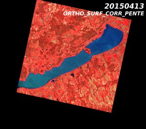
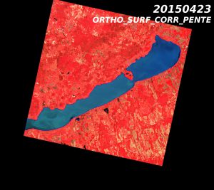
Lake Balaton Hungary
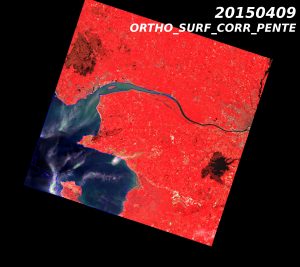
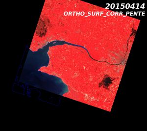
Pornic, France
The results are good (see the images of Lake Balaton, Hungary and Pornic, France, above). If you click on the images, you will see that the very thin plane contrails, circled in green, have been detected. The plane contrail shadows (circled in balck) were missed, but it is very difficult to detect such a faint signal. On the Pornic image the very thin cloud is well detected as well as its shadow. In both cases. A very thin cloud is missed in the south east corner, because this region was only seen on one image, and therefore the multi-temporal detection does not work. Not only the cloud detection works, but the atmospheric correction also looks fine.So this is good news, we should be able to start operational production soon !On Lake Balaton site, It is also amazing, to see how the vegetation changed in 10 days : on the first image, most of the forests were dark with no leaves, while they become bright… red on the second image. In the Pornic images, you may see two dark zones corresponding to two wetlands, and we should see the vegetation grow when the water retreats during summer. The forests are much more advanced than in Hungary, and highlight the difference between an Atlantic and a continental climate, and all this shows that Sentinel-2 will be a great tool to study vegetation phenology at a high resolution. Good observers will also notice that the footprints of the SPOT5 images may change from one image to the other. This is the main issue we have had to deal with so far, but we think we have found a solution, and the footprints should be more stable from now on.


