Petition results (to keep S2A operational after S2C launch)
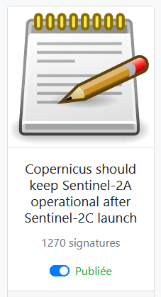
Last week, I issued a petition to keep S2A operational, this post will give you some results. i will keep updating this post regularly, so please go-on signing the petition or forwarding it to your colleagues. Although I have not been trained as a lobbyist, and I have some regrets on how i did it, the petition and our communication has had a very large success. I guess the wood was very dry, and the fire spread very fast when I lighted the match.
The campaign started with a blog post which explained why it is important to keep S2A operational, after S2C starts its operational duty. The blog post was relayed on LinkedIn and a petition. site was created. The tool I used, based on the « pytition » open source software, which works perfectly, is very simple and straightforward to set-up, but does not allow to collect the affiliations of the persons who sign (which is a pity). I thought I would collect the affiliations from the email address, but hundreds of signatories have signed with a gmail address or with various email service providers.
Anyway, here are several statistics I gathered on these posts and on the petition on September 9th :
| Publication | Statistics |
|---|---|
| Blog | 1200 visits |
| 82 000 impressions, 967 likes, 190 republications |
|
| Petition | 1684 confirmed, 2050 total (confirmed+unconfirmed) |
I would like to thank everyone who signed, liked, forwarded, republished, retweeted, retooted (on Mastodon) ! I would have never dreamed to get 1500 signatures in one week only, I increased the goal progressively from 500 to 1500 ! I think our colleagues at ESA and EU should be proud of this achievement, which shows the importance and success to this great Copernicus mission in Europe, but also on all continents, in academy, research, companies, agencies, regions, governments, and even NGO.
Regarding the petition, there are several caveats to be mentioned before analyzing the results :
- Signing the petition is an individual decision, it does not mean that the organism/company for which the signatory works agrees with the signature, but it should be the general case. I will preserve the identity of the signatories, and only send the petition file to ESA and the EU, and quote the affiliations.
- Even if they signed with gmail, I recognized a few of the petitioner names, and I know the company for which they work. Of course, I will not reveal their names here, but I hope you will trust me on this conversion.
- To sign a petition requires a two step process. First fill the form with a email address, and then confirm the email address after receiving an email. It turns out 1250 persons confirmed their email address, and 250 did not. My statistics are based on the total number. I swear I did not add anyone myself. The files sent to ESA and EU will mention if the email was confirmed or not.
- My network is mainly among space agencies, and then in academy. This is largely visible in the table below. However, many persons form private companies signed, including a few CEO.
- The duty of confidentiality applied among space agencies reduced the number of petitioners, but I have had feedback on the interest from many colleagues at CNES, ESA, EU. In fact, everyone I talked to would like to maintain S2A, but I know no one in charge of the funding decisions…
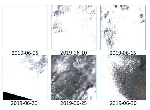
- It is interesting to note the presence of companies which produce earth observing satellites, but are very keen on using Sentinel-2 data as reference, thanks to the excellent quality of its data.
- The numbers between parentheses are the numbers of petitioners per affiliation, when there is more than one.
| Domain | Affiliations |
|---|---|
| Research/ Academy | AT: BOKU Vienna (3), Salzburg (4) AU: New south Wales BR: Sao Polo, IPAM (Amazonia), Rio de Janeiro, Ceara, Viçosa, Mato grosso, BE: CRA -Wallonie (3), UC Louvain (7), Leuven, Bruxelles, Namur CA: Ottawa, Carleton, Alberta, Laval, Rimouski (Quebec), Sherbrooke, Victoria CL: Univ Chile (2) CH: Agroscope, Zurich, Bern, Geneva, Lausanne, Zurich : Ethz (2), Uzh(2), SwissTopo (3) CN: Chinese Academy of Science (3), Wuhan(3), Nanjing (6), Univ of Geosciences CZ: Prague (Charles University) DE: Fraunhofer institute Bonn, Thunen institute, Jena(2), Trier, Hamburg, Kiel (4), potsdam, Humbold Berlin (5), Osnabrueck(2), Tuebingen DK : LBST(2) EE: Tartu(2) ES: CSIC (8), Cantabria (6), Granada (4), Malaga, Valencia, Salamanca FI: Aalto (4) FR ; INRAE (16), IRD(14), CNRS (3), CIRAD, CEREMA, CEA, IGN (3), ONERA(3), OFB, Bordeaux, Toulouse (13) UT3, Toulouse INP (3), Ecole Normale Supérieure (2), ENSAE, Lyon, Paris Saclay (5), Paris, Strasbourg (6), IMEV Villefranche (8), Supagro (2), Montpellier, Nantes, Littoral, Orleans, Marne-la-vallée, Grenoble, Réunion(3), GR: Athens (4), Macedonia KE; NDMA : (Drought Mapping Agency) KR: Busan IE: Cork IL: Technion (4), Volcani Agri(3) Haifa(12) et jérusalem (9), IN; IITD (2) IT; CNR (10), Pavia, Torinio, Bologna, Napoli, Milano, Politecnico Milano, Calabria, Messina, Viterbe Tuscia (3), Venezzia, JP: Hokudai LE: Beyrouth, MA: Marrakech, El jadida NL: Wageningen (6) PT: Lisboa (6), Evora SG: Singapour (4) SI: Ljubiana SE: Lund TU: Tunis, TR: Istanbul (3), Bursa UK: NPL (8) Plymouth, London, Leicester, Liverpool, Surrey, Stirling, Bath, Cambridge (8), leeds US; MIT(3), Wisconsin(4), Michigan, Colorado, Cornell, Oregon, Oklahoma, Connecticut (2), South Florida (5) Maryland (6), Texas, Columbia,Providence(2), Harvard, Stanford (2) Boston (13), Kansas, Delaware, California, New York (2), Washington (3) |
| Agencies | CNES (11), DLR (14), NASA(4), ESA (4), INPE (14), USGS(3), NOAA(2), VITO(15), EU (6), SATCEN (3), Eumetsat,, FAO(3), UN |
| Companies | – Satellite : Planet, Airbus (9); TAS, ConstellR, Aerospacelab (4), Earthdaily, Satellite-Vu, Spacetech-i (STI) – Software, engineering : CS, GMV, Google, CLS, ACRI-ARGANS-ARCTUS (6), Magellium (5), CGI, SISTEMA, Brockmann (4), CAP GEMINI, TRACASA(6), cloudferro(2) – Remote sensing Services : EOX, Kayrros (10), Hiperplan (4), Bluecham, Terranis, MEEO (3), Gamma.earth, Orbital-eos (3), Planetek, Orbital-Eye , Kermap (6), Netcarbon(4), MEOSS, I-SEA (4), Kanop (5), latitudo40 (4), mantle-labs (6), Mapsat (3) , WaterInsight (NL), remote-sensing-solutions (3), Satelligence(8), mundialis(2), DHI group(3) – Agriculture : Arvalis, Cargill, E-leaf – Insurance : AXA |
| Government/Local communities | Hauts de France Région, Basque region, Canadian government, Andalucia, Umwelt Bundesamt |
| NGO | WWF (3) |