A new article on the validation of MAJA’s Sentinel-2 surface reflectances

Whether you are a user of the atmospheric correction processor MAJA or THEIA’s Sentinel-2 Level 2 products, you will probably be interested to read our new article on the validation of MAJA Sentinel-2 surface reflectances. The article is published in open access in Remote Sensing :

Colin, J.; Hagolle, O.; Landier, L.; Coustance, S.; Kettig, P.; Meygret, A.; Osman, J.; Vermote, E. Assessment of the Performance of the Atmospheric Correction Algorithm MAJA for Sentinel-2 Surface Reflectance Estimates. Remote Sens. 2023, 15, 2665. https://doi.org/10.3390/rs15102665

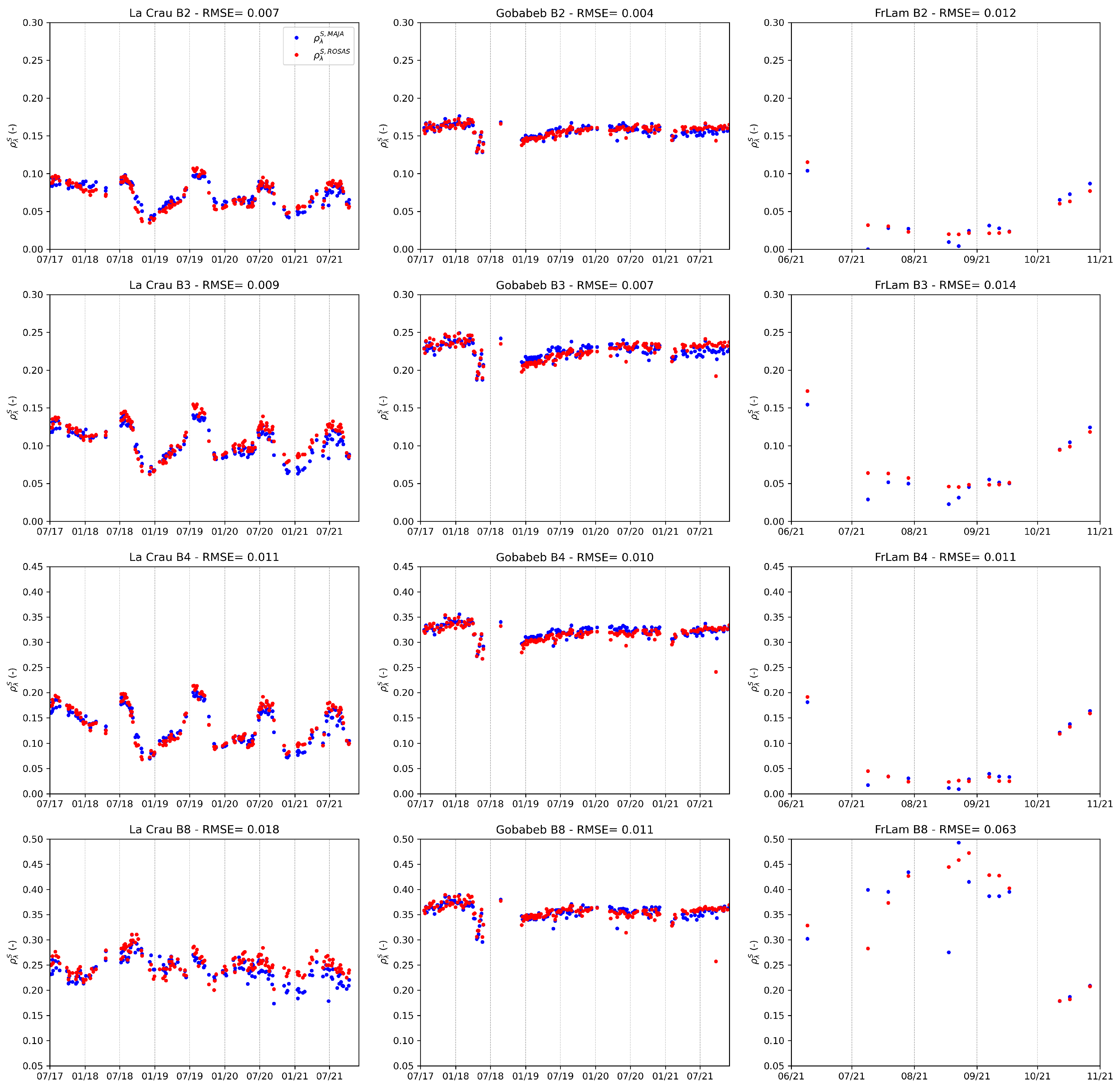
The first part of the paper aims at providing complementary performance assessment to the second Atmospheric Correction Intercomparison Exercise (ACIX-II) by reprocessing MAJA surface reflectances without adjacency nor topographic correction, allowing for an unbiased full resolution comparison with the reference Sentinel-2 dataset. The second part of the study consists of validating MAJA against surface reflectance measurements time series of up to five years acquired at three automated ROSAS stations, among which our latest Lamasquère site. Both approaches should provide you with extensive insights on the quality of MAJA Sentinel-2 Level 2 products.

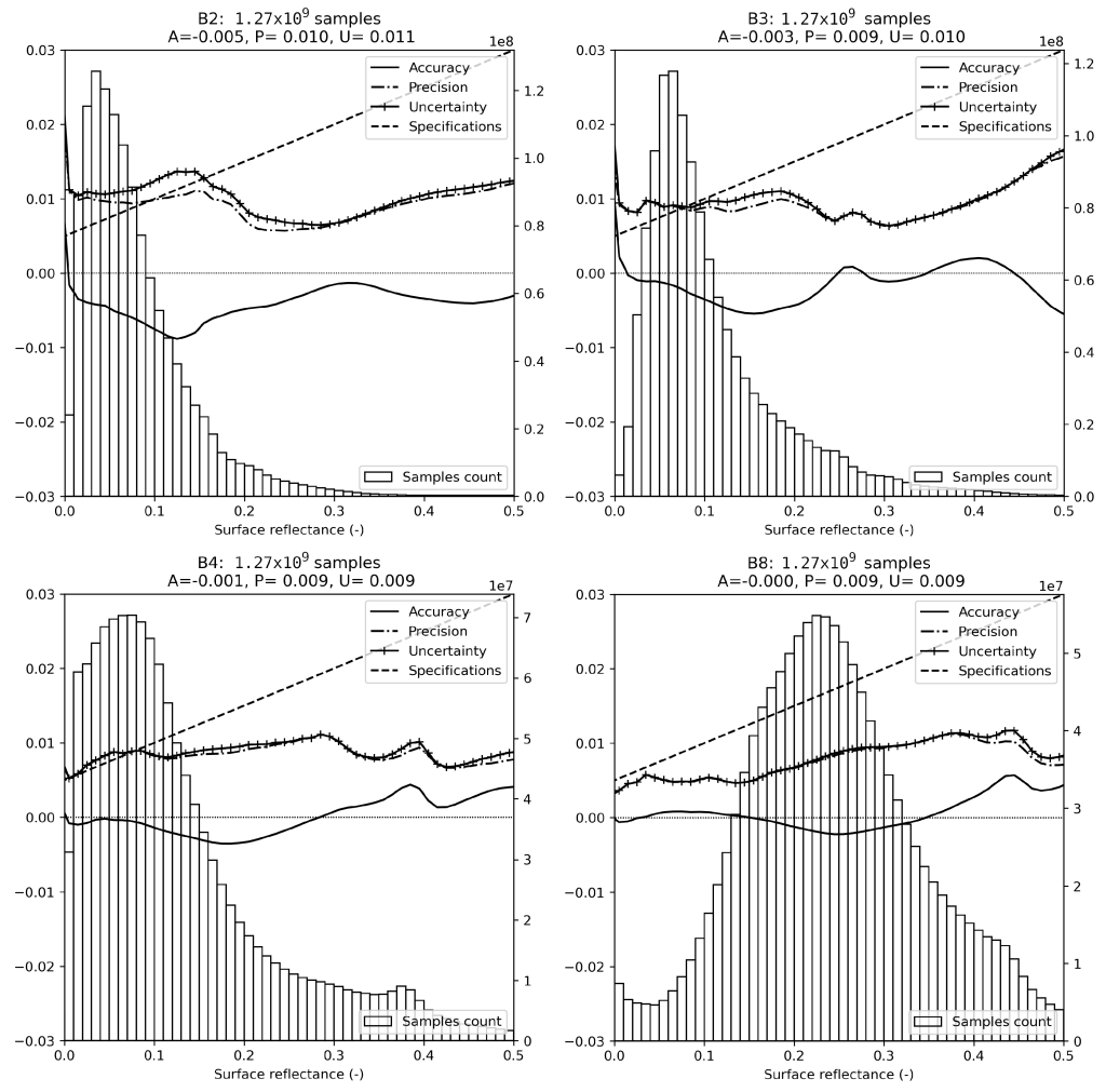
Among other information, you will find estimates of the uncertainties of MAJA against over 1.27 billion pixels from the ACIX-II dataset.

Stacked results of inter-comparison between reference and MAJA ground reflectances for 10 m resolution Sentinel-2 MSI bands. The histogram shows the distribution of reflectances, with pixel count on the right y-axis. The total number of cloud-free pixels used to generate the result is expressed as sample count in plot title. The accuracy, precision, and uncertainties as defined in Equations (2)–(4) are represented along reflectances values along the left y-axis. A simple affine function shows the suggested specification for Sentinel-2, i.e., spec=0.05ρ+0.005 according to Vermote et al 2008.

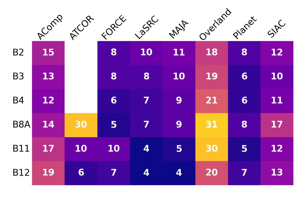
And comparisons of MAJA uncertainties against other well known AC processors evaluated in Doxani et al. 2023.

Comparison of the uncertainties U∗10−3 on the estimation of the Sentinel-2 surface reflectances reported by Doxani et al. for various AC processors together with MAJA uncertainties. Three of the best results, FORCE, LaSRC, and Planet use the same radiative transfer code as the reference, while MAJA uses a different one. Using the same Radiative transfer code is an important advantage on this criterion.

This study also presents a comparison of MAJA against the in-situ measurement of the ROSAS Robotic network, with up to five years of records :

Comparison of MAJA Sentinel-2 L2A (blue dots) and ROSAS (red dots) ground reflectances for sites La Crau, Gobabeb, and Fr-Lam (left to right) for Sentinel-2 bands 2, 3, 4, and 8 (top to bottom). Here, MAJA L2A products are computed using the CAMS auxiliary data.

Read the full paper : https://doi.org/10.3390/rs15102665


Plus d'actualités

BIOMASS, the third launched satellite mission designed at CESBIO !

After SMOS in 2009, and VENµS in 2017, the CESBIO Laboratory is very proud to see its third proposed mission, Biomass, reach orbit. As always, it has been a long journey from the idea, at the beginning of the century, to the selection in 2013 as the seventh Earth Explorer Mission by ESA, to the […]

Sentinel-2 reveals the surface deformation after the 2025 Myanmar earthquake

Sentinel-2 captured several clear-sky images of Myanmar before and after the 28 March 2025 earthquake. The animation below shows a 5-day apart sequence of images captured by Sentinel-2B and Sentinel-2C (10 m resolution) near the epicenter located close to Mandalay. The surface slip due to the earthquake follows the Sagaing Fault, a major fault in […]

Evolution de l’altitude de la ligne de neige au cours des 41 dernières années dans le bassin versant du Vénéon (Oisans)

Pour contribuer à caractériser les conditions hydrométéorologiques lors de la crue torrentielle qui a frappé la Bérarde en juin, j’ai analysé une nouvelle série de cartes d’enneigement qui couvre la période 1984-2024 [1]. Grâce à la profondeur temporelle de cette série, on constate que l’altitude de la ligne de neige dans le bassin versant du […]

Rechercher