VENµS satellite new phase started: high resolution images every day (almost)
VENµS, the French-Israeli satellite that goes up and down, reached its new orbit on the first of March, and after first tunings of the programming and telemetry, we have started having our first steady acquisitions on March the 15th. This new phase is called the VM5 phase. On the selected sites, images will be taken every day (sometimes every second day), with a 4 m resolution, and with 12 spectral bands in the visible and near infrared. We will have a bit of a commissionning phase to do in the coming weeks, and we need to prepare all the geometric reference images to obtain an accurate registration. The L1C, L2A and L3A data will only be released at the end of spring (hopefully).
The list of selected VENµS sites is available on the map below. It might be not fully definitive, and we cannot exclude that a few sites will have to be removed in the coming days according possible difficulties in the acquisitions. Thiis uncertainty is due to differences between the programming simulator, and the reality. On these first days, 20 of the selected sites did not make it to the current programming, we are trying hard to include as many of them as possible. The current list just indicates a high probability for these sites to be included in VENµS programming.
An email will be sent for each proposing team this week.
Choosing those sites kept our team busy for a few months :
- Together with Gérard Dedieu, who did 90% of the work benevolently from his retirement in the Pyrenees, we read all the proposals (almost 90 !) and classified them with priorities between 1 and 5. We quickly figured out that priorities 1 and 2 would be enough to fill VENµS programming.
- The technical team in France and Israel (Sophie Pelou (CNES), Thibaut Faijan (CS-Group), Thomas Cruz (Sopra-Steria)) had then to program all the sites, accounting for all the constraints :
- the satellite moderate agility
- the memory occupation,
- a constraint to have an empty memory on the first orbit
- impossibility to acquire while downloading data to the ground station
- limit the number of downloads, as are they are not free
- Eventually adapt the processors, prepare the reference images for ortho-rectification, check the product quality. This is the work of Jean-Louis Raynaud (CNES), Amandine Rolland, Lucas Tuillier, Laetitia Fenouil (Thales), Sophie Coustances (CNES)
- Process the data ( Marie France Larif, Bernard Specht, CNES) and Theia’s production team (Gwénaëlle Baldit et Victor Vidal, Sopra Steria)
The second part was the hardest, and we didn’t count the iterations necessary with our simulator, checked by our colleagues in Israel. AS we wanted to include as many sites as possible, it took an almost infinite time to obtain an optimised result, and this explains why we were not able to deliver the list of sites earlier.
The result is as follows. I know some of our friends who suggested sites will be disappointed, but this is the best we could program. Due to the constraints, a part of the sites could only be programmed every second day instead of every day. I’ll soon have a map with two different colours depending on the revisit.
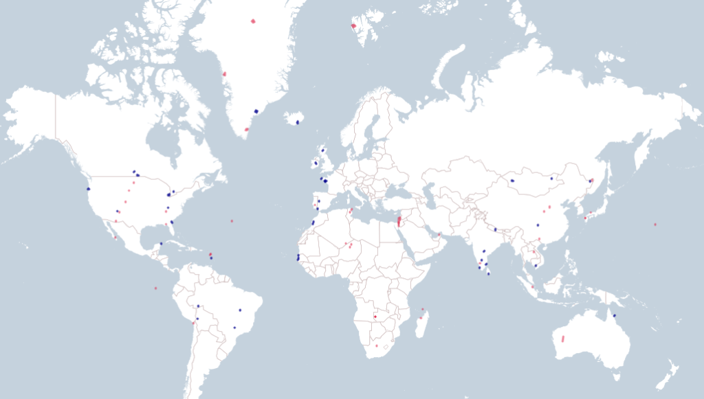
Sites displayed in blue have a one day revisit, and red sites have a 2 day revisit. Click on image to see the interactive map. and zoom