[Directional effects] how far can we extend Sentinel-2 field of view ? Conclusions
This is the final post of a series of studies we did to find out how far we can extend the field of view of next generation of Sentinel-2 satellites. I hope I did not lose most readers in the length of the previous posts. For the readers who land on this page, which will spoil all suspense of the series, the blog thread starts here.
We tried to answer the following questions in our work for ESA and Airbus:
- Until which zenith viewing angle is it possible to correct directional effects with a directional model independent from the land cover?
- Until which zenith viewing angle is it possible to neglect the effect of orientation angles?
- Until which angle can we avoid hot-spot ?
- If the field of view is extended, should we keep the constant view angles that we currently have in Sentinel-2
0. Performance objective
It is very difficult to define a performance requirement for a mission such as Sentinel-2, with infinite applications, as each of them would yield different needs. For this study, we adopted a pragmatic rationale which is that the uncertainty brought by directional effects after a simple correction should be negligible when compared to other sources of errors, such as atmospheric correction, cloud detection, absolute calibration, noise from the instrument…
For instance, absolute calibration requirement is 5%, 3 sigma, while the additive noise of atmospheric correction is ~ 0.03 in reflectance unit, 3 sigma.
As a result, we defined a goal for the unknown part of directional effects $$\delta$$ to be lower than half the above mentionned errors :
$$\delta < 0.015 + 0.025* \rho $$
where $$\rho$$ is the surface reflectance
1. Until which zenith viewing angle is it possible to correct directional effects with a directional model independent from the land cover
The study reported in this post shows that a directional correction with a simple model agnostic of the land cover would already leave errors of +/- 5% at the edges of the current field of view of Sentinel-2 (12° expressed in view zenith angle). This is already not negligible, it is already greater than the requirement we defined above. However, as readers of numerous papers in the literature based on Sentinel-2 data, we have witnessed that users tend to use both swaths in the overlap regions of Sentinel-2 orbits, despite the differences in viewing angles. It means that a lot of users give priority to the revisit rather than to the accuracy of their retrieval.
The study also showed that the deviation of directional effects between various types vegetation covers is almost linear in the range of the studied view zenith angles [+/- 24°]. This means that extending the field of view to 24 degrees would give variations of +/- 10% around the mean directional model. It would prevent accurate uses of time series without an accurate directional correction. And the amount of data to perform an accurate correction is probably too high to allow to process it at country scale (an accurate correction requires to know the type of plant, the surface reflectance of the ground, the development stage of the plant, the architecture of the canopy…). As a result, our recommendation is to only extend a little the field of view, until 15 or 16°, which will increase the uncertainty by 25 % at the very end of the field of view.
2. Until which zenith viewing angle is it possible to neglect the effect of orientation angles?
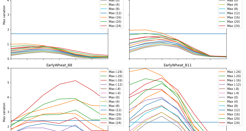
As shown in this post, the answer is not straightforward. We have shown that with the current field of view of Sentinel-2, that reaches 12° in VZA, the row orientation effects can already be much higher than the noise due to the instrument or to the early stages of processing. However, we noticed that despite this effect, users find that Sentinel-2 fits well to their needs. We decided to proceed further and to analyze the dependency of directional effects with zenith viewing angle, after discarding the row orientation roughly aligned to the sun azimuth., which accoun to 15% of the observations, assuming a random orientation of crops globally. Of course, this decision is questionable.
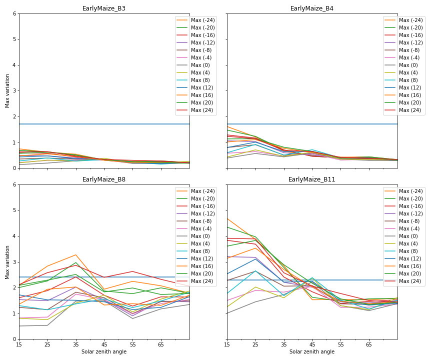 Early maize Early maize | 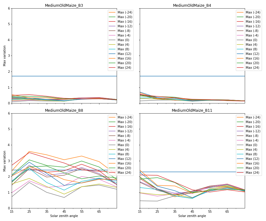 Medium maize Medium maize |
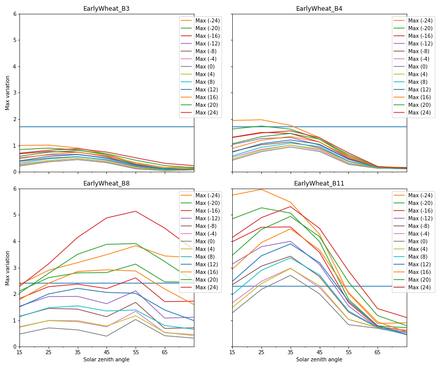 Early wheat Early wheat |
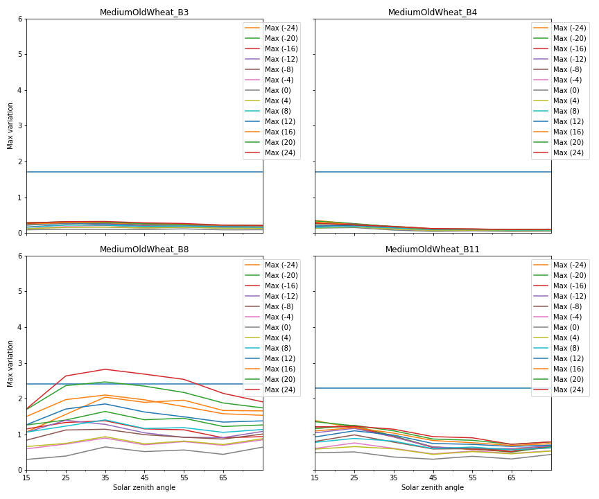 Medium wheat |
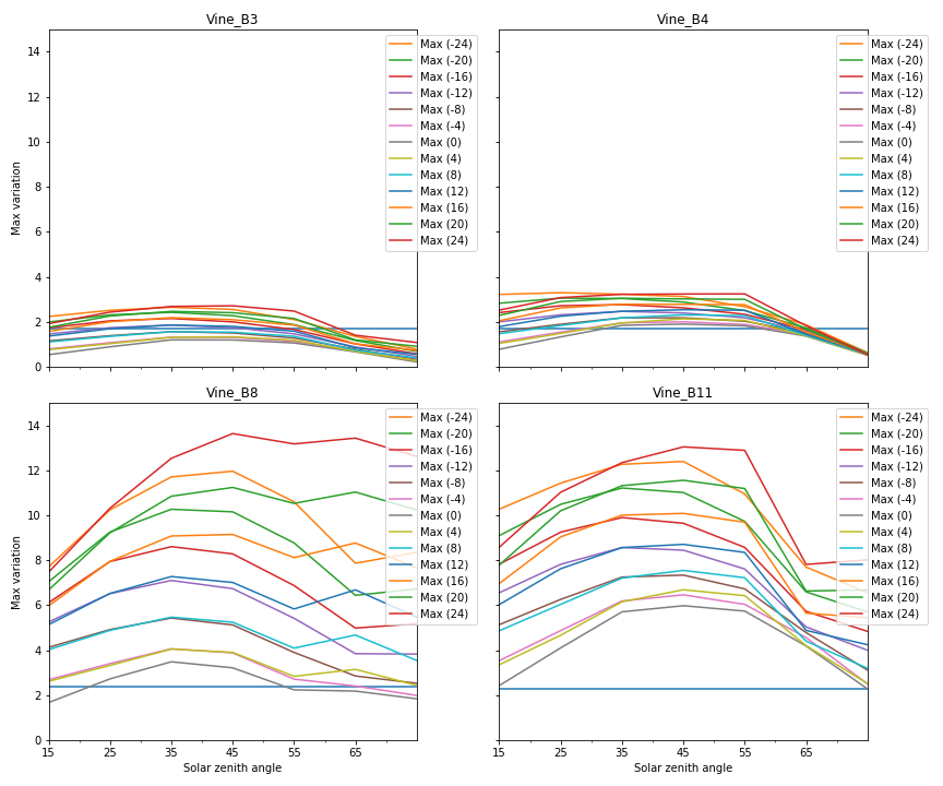 Vineyard Vineyard | Summary of the directional effect variations (3 sigma) due to orientation, as a function of zenith view angle (colour of the plot), and solar zenith angle. The horizontal blue line corresponds to the average value of the performance goal $$ \delta $$. Values are expressed in reflectances $$\times 100$$. |
In summary, our performance objective delta is not met :
- when the rows are aligned with the sun direction (with a difference up to 20°).
- for crops with a large spacing between rows such as vineyards
- in the SWIR band for Vineyard and crops at early stage
- above 16° of view zenith angle in the other cases, which represents most of the cases, after all
So this study has two conclusions
- directional effects due to orientation can be quite large, and should be taken into account already with the current field of view of Sentinel-2.
- increasing the filed of view does not degrade the situation until 16° of maximum View zenith angle.
3.Until which angle can we avoid hot-spot ?
With the current configuration of Sentinel-2,a study from D.Roy’s team showed that the exact backscattering direction (hot-spot) does not enter in the field of view of Sentinel-2 [1]. At the time of overpass of Sentinel-2, the minimum sun zenith angle is 18°, and this does only happen on a few dates. With a 20° field of view, the hot spot would start to enter more regularly in the field of view if it reached 20° of zenith viewing angle. With a margin of 4 and 5 degrees, this directs us also to a maximum viewing angle of 15° or 16°.
4. Should we keep the constant view angles that we currently have in Sentinel-2 ?
All the above studies point to a maximum view zenith angle of ~16°, that would still allow accurate retrievals without requiring a large complexity of the processing. However, this limit is only a magnitude, it is not based on a strict comparison to a performance requirement, but more on knowledge on how Sentinel-2 data are used in its large community. Such a result is therefore highly questionable, and we would be happy to recive feedback in the comments section of this post.
Increasing the field of view has some advantages
- better revisit frequency with the same number of satellites,
- possibility to estimate the BRDF from the data themselves thanks to the enhanced revisit
Should Copernicus and ESA decide to increase the field of view, the next question is whether we should keep or not the current constraint of constant viewing angles, except in the overlap regions. The main advantage is that successive acquisitions can be compared easily on the short term. However, it does not mean that the acquisitions are not affected by directional effects, but just that directional effects result in a bias that depends on the view zenith angle (and even some variations due to the slow evolution of sun ables along the season.
But there are drawbacks, suppose that your application requires a viewing angle below 12°, well, some place sinthe world will be always observed with 15°, and it will be difficult for you to get good results there
. Relaxing the constant angle constraint will enable the user to select only the suitable angles, at the expense of some revisit.
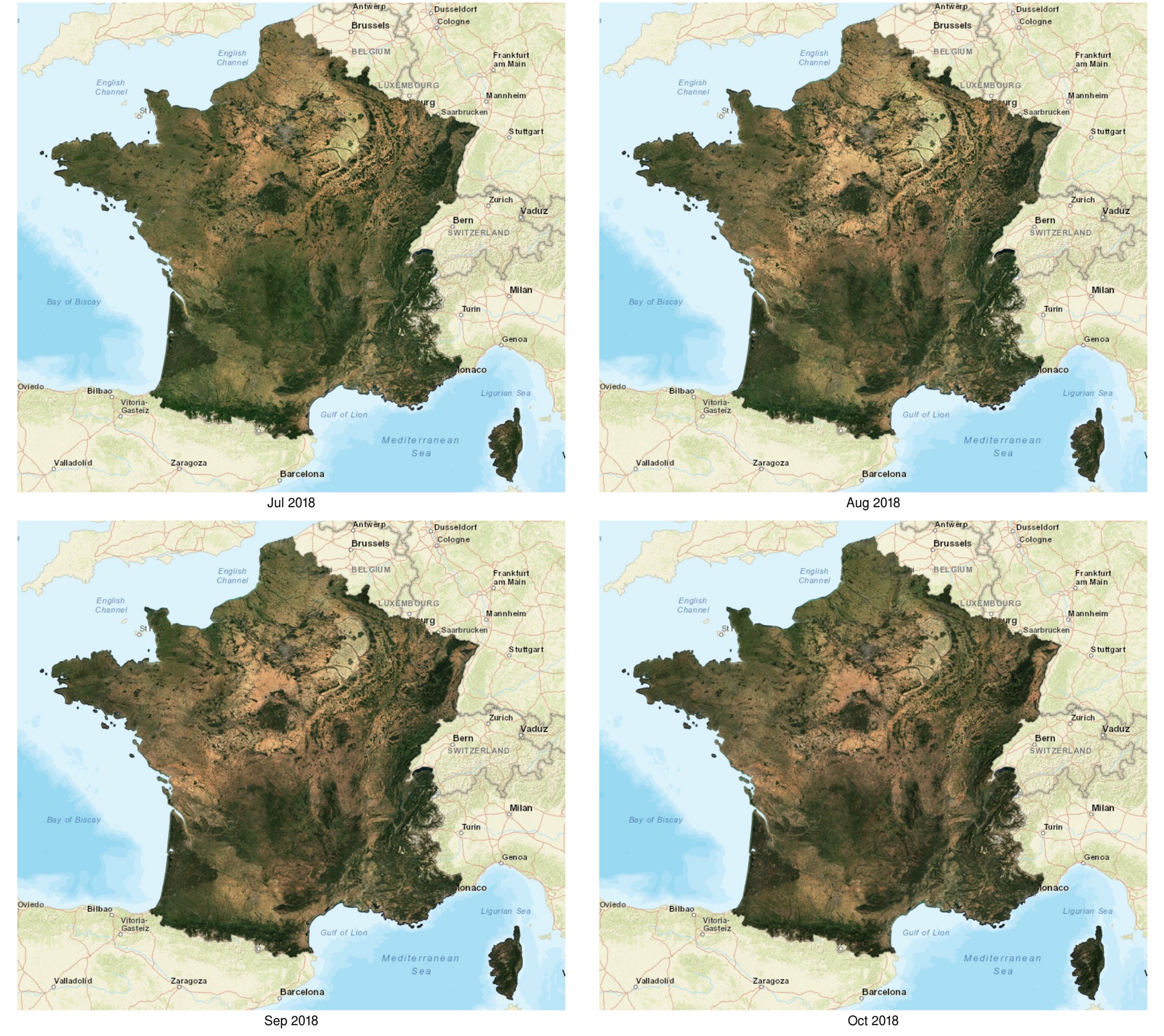
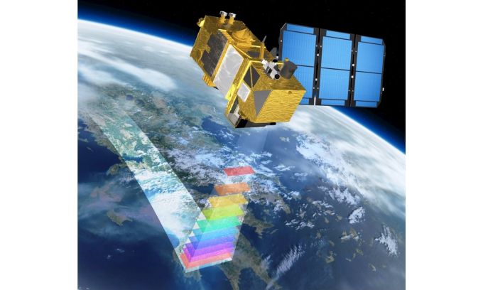
Moreover, with the current constant viewing angles, here in Toulouse, we have only one revisit every 5th days, but in Carcassonne, 100 km South East, there are 2 revisits every 5 days, that’s unfair. With a longer orbital cycle, the revisits would be better distributed, as shown on the Trishna example on the right.
Although I have always been in favor of constant view angles in the past, my current feeling is that with a greater field of view, it is interesting to shift to longer orbital cycles with subcycles allowing revisit under different viewing angles. But here again, feel free to comment if you disagree, or even if you agree ;).
References
[1] Li, Zhongbin, Hankui K. Zhang, and David P. Roy. « Investigation of Sentinel-2 bidirectional reflectance hot-spot sensing conditions. » IEEE Transactions on Geoscience and Remote Sensing 57.6 (2018): 3591-3598.