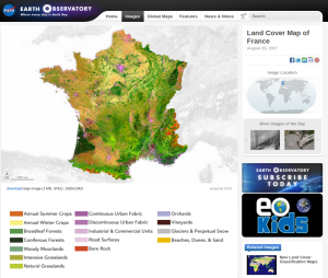
La NASA choisit le produit d’occupation des sols OSO du CESBIO comme « image du jour «

![]() =>
=>![]() C’est une reconnaissance bien méritée pour le produit d’occupation des sols OSO développé et produit au CESBIO : le blog « earthobservatory » de la NASA a consacré son article « image du jour » du 15 août à ce produit. Ce travail a été conduit dans le cadre de Theia, avec le logiciel libre iota2 développé au CESBIO. Grâce à l’utilisation de toute l’information contenue dans les séries temporelles d’images, la chaîne iota2 arrive à fournir un résultat de grande qualité, tout en étant complètement automatique. L’équipe de Jordi Inglada a publié une première carte en 2015, basée sur les données LANDSAT 8 acquises en 2015, avec une résolution de 30m. Cette production a été suivie, début 2017, d’une carte basée sur les données Sentinel-2, acquises en 2016, cette fois à une résolution de 10m.
C’est une reconnaissance bien méritée pour le produit d’occupation des sols OSO développé et produit au CESBIO : le blog « earthobservatory » de la NASA a consacré son article « image du jour » du 15 août à ce produit. Ce travail a été conduit dans le cadre de Theia, avec le logiciel libre iota2 développé au CESBIO. Grâce à l’utilisation de toute l’information contenue dans les séries temporelles d’images, la chaîne iota2 arrive à fournir un résultat de grande qualité, tout en étant complètement automatique. L’équipe de Jordi Inglada a publié une première carte en 2015, basée sur les données LANDSAT 8 acquises en 2015, avec une résolution de 30m. Cette production a été suivie, début 2017, d’une carte basée sur les données Sentinel-2, acquises en 2016, cette fois à une résolution de 10m.
Il semble que le site de la NASA se soit focalisé sur LANDSAT 8, et ait un peu oublié le produit Sentinel-2. Pour les besoins de la communication, toutefois, même Jordi n’hésite pas à recourir au « story telling » : “I can spend hours looking at the map,” Inglada said. “Seeing the Earth surface with this detail is impressive and shows the beauty of our planet.”Quand on sait que seule la beauté d’une matrice de confusion arrive à émouvoir Jordi, on peut mesurer l’ effort de communication ! 😉
Reference


