USGS now delivers atmospherically corrected LANDSAT data
USGS and NASA just released a new LANDSAT level 2A product (surface reflectances corrected for atmospheric effects with a cloud mask, a cloud shadow mask, and a water and snow mask). The thermal data are expressed as brightness temperatures at the top of atmosphere. This product is only available for Landsat 5 and Landsat 7 yet, but I know NASA is working on LANDSAT 8 atmospheric correction processor (Edit : LANDSAT 8 level 2A has been released in december 2014). The French Land Data Center Theia also distributes atmospherically corrected LANDSAT 8 data, but only over France.
Since May 2013, the atmospherically corrected LANDSAT 5 and LANDSAT 7 data are available on earthexplorer site. They are not so easy to find : click on the « data sets » tab and select your satellite in the « Landsat CDR » menu. You can order your data at once and the data will be available for download the next day (unless you ordered a few hundreds of them). It is only a pity that USGS does not own a large part of the historical LANDSAT 5 data acquired in ESA receiving stations. The data should be transferred one day, and a lot of users are awaiting for that.
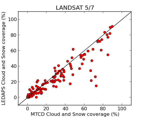
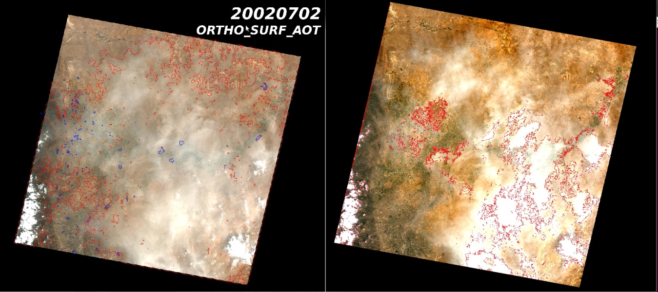
The LANDSAT surface reflectance images are produced with the LEDAPS processor. [Vermote et Masek 2006]. LEDAPS uses the DDV method to estimate the aerosol optical thickness, and a bunch of spectral tests using only one date to detect clouds. Last year, a comparison was done with our method (MACCS), and the results were very close, event if the mono date method is not as accurate as the multi-temporal one (see the figures). LEDAPS is also less accurate for the cloud shadow detection which is even more tricky than the cloud detection. But nevertheless, it is evident that these new products will help many users in their applications.
The LANDSAT surface reflectance product is by now the only existing or foreseen level 2A product at the global level. The French Land Data Center THEIA also delivers Level 2A processed with the THEIA prototype for SPOT4 (Take5) (available here) and for the LANDSAT (5,7,8) data acquired since 2009 over France (available there), but they do not have a global observation capability.
Regarding Sentinel-2, ESA has decided not to produce level 2A products (which is a pity, even if we can understand that producing all Sentinel-2 data to level 1C is already a challenge). The French Land Data Center THEIA is already committed to process the whole Sentinel-2 data over France, and over other regions and countries to be hosen, covering up to 10 times France’s area. but the application of MACCS to the global land surfaces is not decided yet, even if THEIA is working into it.
Reference : Masek, J. G., Vermote, E. F., Saleous, N. E., Wolfe, R., Hall, F. G., Huemmrich, K. F., … & Lim, T. K. (2006). A Landsat surface reflectance dataset for North America, 1990-2000. Geoscience and Remote Sensing Letters, IEEE, 3(1), 68-72.