
SAT-IRR: Satellite for Irrigation Scheduling
 =>
=>  Following the irrigation scheduling experiment in Morocco during the SPOT4-Take5 experiment (Le Page et al, 2014), a Web tool owing to help the irrigation decision making is under development (http://osr-cesbio.ups-tlse.fr/Satirr). The tool is functional on three Landsat8 tiles: Marrakech in Morocco, Kairouan in Tunisia, Toulouse, France. As the tool is addressing irrigators, the idea is to set an irrigated plot of the simplest and fastest possible way. After drawing his plot on a base map, the user answers to 4 questions. He chose his culture among 7 options currently parameterized (corn, wheat, olive …), its soil among the 12 USDA typical soils, the sowing date and irrigation method (flooding, sprinkler or drip). This rough initialization is adequate launch the service although, at any time, the user can change the plot contours or refine parameterization if he knows the soils, the peculiarities of its crop, etc.
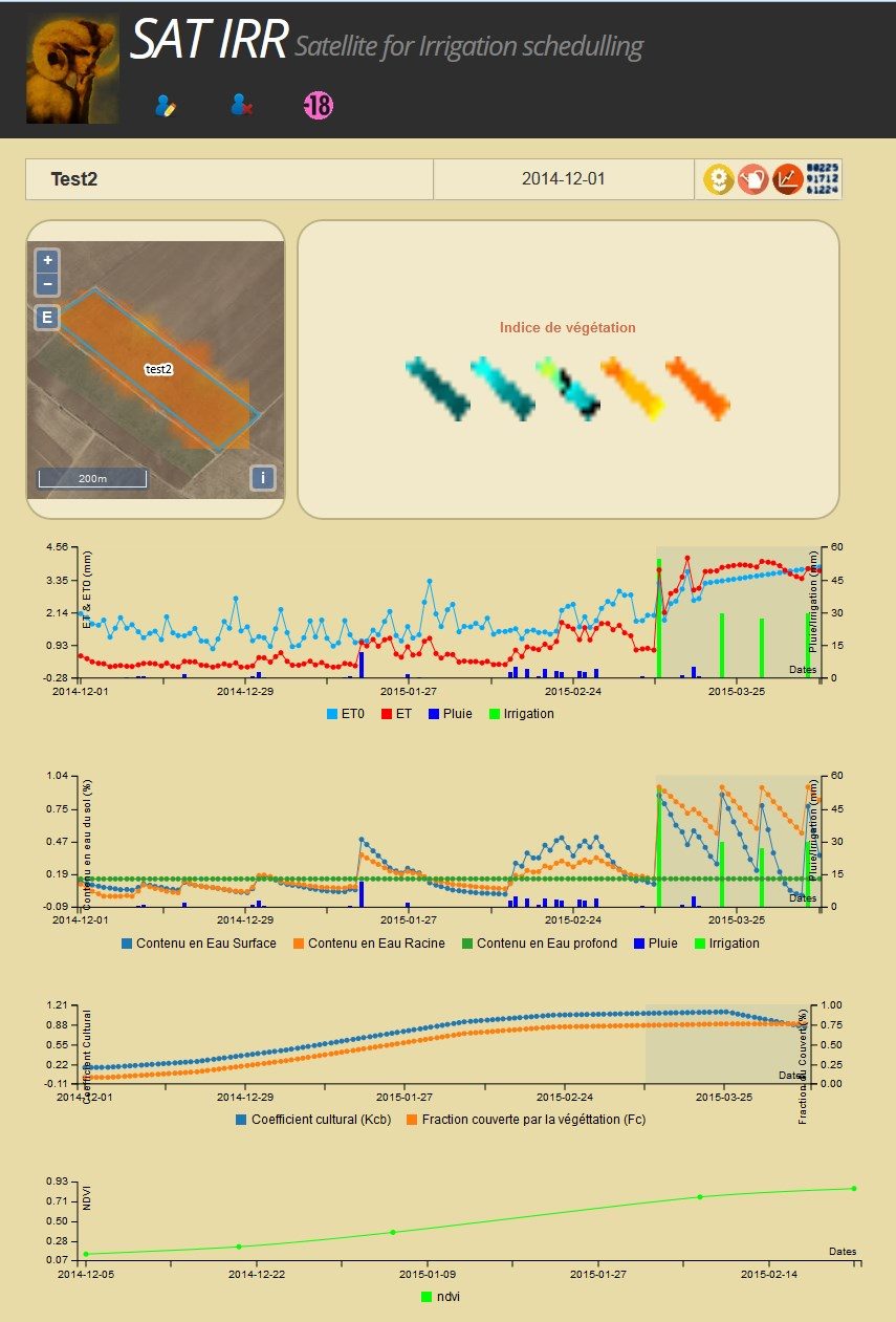
Initially the server makes an approximation of an average behavior of the plant. For this, a monthly climatology is compiled (multi-annual average of weather parameters) and then interpolated to daily values, while the average behavior of the plant is extracted from FAO-56 Tables « FAO Irrigation and Drainage No. 56 : Guidelines for Computing Crop Water Requirements » (Allen et al, 1998). In a second step, the satellite images already on the server are examined and the relationship between NDVI and Basal Crop coefficient (Kcb) and percent of ground covered by vegetation (Fraction cover, Fc) are determined at each date by averaging on the plot.Past weather is populated by measurements on the nearest synoptic station of the World Meteorological Organization and synthesized in the form of daily reference evapotranspiration (ET0) and rainfall. Forecasts are obtained by the API of the Norwegian Meteorological Institute.Finally, a water balance very close to the one described in the FAO-56 is calculated by combining typical crop behavior and climate, satellite imagery, weather data and forecasts and projection into the future of crop development. The goal is to propose a date and dose of irrigation. In addition to updating the weather (measures and forecasts), the server will check every day for the availability of new images (only Landsat8 for the time being). If there is availability, the tile is downloaded, it is then corrected for atmospheric effects using the information provided by the nearest photometer from the Aeronet network using the SMAC code (Rahman & Dedieu, 1994), then a cloud mask is created and NDVI is calculated. This image is stored as the original file is discarded to not overload the server.All parameterization / measures / prediction are stored in a postgres / postgis database that links with a web client interface. The user can view the results in tables or graphs, and add its own irrigation in another dedicated interface.While the interface is still a little rough, we are essentially considering developments on the server side:
- Adaptation to Sentinel-2: the transition to S2 should not be a hassle. However, it will be necessary to adjust the calculation of the tiles to download, the download code and format reading.
- Use of Sentinel-1: In the current state, the well-performance of water balance is based on the actual information of irrigation provided by the user. We plan to test the use of S1 images to determine the irrigation dates.
- Access to local agro-weather stations: As part of the development of the Environmental Information System in Cesbio, telemetry of several weather stations has been settled up (eg, see http://trema.ucam.ac .ma) (Jarlan et al, 2015), we have to make these stations accessible through a standardized web service like Sensor Web.
- Introduction of collective irrigation network. The PhD work of Kharrou (2013) and Belaqziz (2013, 2014) have shown that remote sensing can be used to optimize water rotations of an irrigated command. We plan to offer the possibility of introducing a set of plots to associate it with a distribution network and ultimately offer an optimized arrangement of the water rotation. However, at present, this goal is more into the order of a challenge!
- We are currently working on a procedure to introduce wheat yield using remote sensing data (J. Toumi PhD Thesis) and further expect to input an early wheat yield prediction into the tool.
If you want to try it out, be my guest, it’s free. If you want to try it out on other regions, please contact me! References:
- Le Page M., J. Toumi, S. Khabba, O. Hagolle, A. Tavernier, M. Kharrou, S. Er-Raki, M. Huc, M. Kasbani, A. Moutamanni, M. Yousfi, and L. Jarlan, “A Life-Size and Near Real-Time Test of Irrigation Scheduling with a Sentinel-2 Like Time Series (SPOT4-Take5) in Morocco,” Remote Sens., vol. 6, no. 11, pp. 11182–11203, Nov. 2014.
- Allen R., L. Pereira, D. Raes, and M. Smith, FAO Irrigation and Drainage n°56: Guidelines for Computing Crop Water Requirements, no. 56. FAO, 1998, pp. 273–282.
- Rahman H. and G. Dedieu, “SMAC: a simplified method for the atmospheric correction of satellite measurements in the solar spectrum,” Int. J. Remote Sens., vol. 15, no. 1, pp. 123–143, 1994.
- Kharrou M.H., M. Le Page, A. Chehbouni, V. Simonneaux, S. Er-Raki, L. Jarlan, L. Ouzine, S. Khabba, and A. Chehbouni, “Assessment of Equity and Adequacy of Water Delivery in Irrigation Systems Using Remote Sensing-Based Indicators in Semi-Arid Region, Morocco,” Water Resour. Manag., vol. 27, no. 13, pp. 4697–4714, Sep. 2013.
- Belaqziz S., S. Mangiarotti, M. Le Page, S. Khabba, S. Er-Raki, T. Agouti, L. Drapeau, M. H. Kharrou, M. El Adnani, and L. Jarlan, “Irrigation scheduling of a classical gravity network based on the Covariance Matrix Adaptation – Evolutionary Strategy algorithm,” Comput. Electron. Agric., vol. 102, pp. 64–72, Mar. 2014.
- Belaqziz S., S. Khabba, S. Er-Raki, L. Jarlan, M. Le Page, M. H. Kharrou, M. El Adnani, and A. Chehbouni, “A new irrigation priority index based on remote sensing data for assessing the networks irrigation scheduling,” Agric. Water Manag., vol. 119, pp. 1–9, Mar. 2013.
- Jarlan L., S. Khabba, S. Er-raki, M. Le Page et al, “Remote sensing
of water resources in semi-arid Mediterranean basins: The Joint International Laboratory TREMA,” Int. J. Remote Sens., vol. (under review), 2015.

