How to make a mosaic of Theia snow products in three command lines

Assuming that you have downloaded from Theia and unzipped several products in the same directory. Assuming that you have a Linux OS with GNU Parallel, GDAL and OTB command line utilities installed..


Then, in your terminal, type:

# Get the color table
wget https://gitlab.orfeo-toolbox.org/remote_modules/let-it-snow/-/raw/75-lis-color-table-for-otb-not-updated-after-changed-nodata/hpc/LIS_SEB_style_OTB.txt
# reproject all SNW raster products to a common system (here Web Mercator) and assign 255 to nodata
parallel gdalwarp -srcnodata 255 -overwrite -r near -t_srs "EPSG:3857" {} {/} ::: $(ls SEN*/*SNW*.tif)
# Apply color table
parallel otbcli_ColorMapping -in {} -out c{} uint8 -method.custom.lut LIS_SEB_style_OTB.txt ::: $(ls S*SNW*.tif)
# Merge colored images and set 0 to nodata
gdal_merge.py -n 0 c*tif -o mosaic.tif -co COMPRESS=DEFLATE

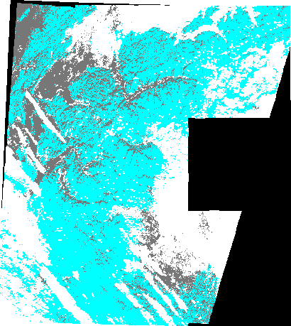
This is yesterday’s snow cover map of the entire French Alps (10 December 2020). Snow is cyan, clouds are white.

Plus d'actualités

IOTA2 software mailing list

Hello everyone, We have just created a mailing list for users of the IOTA2 software (iota2 — iota2 documentation). The tool will undergo significant developments in the coming months, and the purpose of this list is to communicate with the community to support these changes and to maintain the processing workflows needed by the users. […]

Evolution des glaciers du Vignemale sous l’œil des satellites Pléiades (2013-2025)

Grâce à DINAMIS, un couple d’images stéréoscopiques a été acquis par Pléiades 1B le 14 septembre 2025. Le modèle numérique de surface (MNS) produit à partir de ces images peut être comparé à un autre MNS de septembre 2013 produit à partir des images Pléiades 1A commandées par Marti et al. (2014). Le glacier d’Ossoue […]

Rapid analysis of the GLOF in Gupis, Gilgit-Baltistan

Pakistan news media reported that a glacier lake outburst flood (the failure of a dam containing a glacial lake) occurred near Gupis, Gilgit-Baltistan, a highly mountainous region administered by Pakistan. Satellite images show that the flood triggered a debris flow, which reached the Gupis valley where it hit the Roshan (Rashon) village and blocked the […]

Rechercher