snow-ice

Suivi de l’enneigement des stations de ski avec Sentinel-2

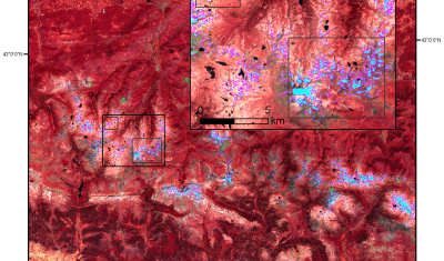
=> Dans le cadre du pôle thématique Theia nous préparons la distribution de cartes d’enneigement établies à partir des images Sentinel-2. Si la méthode utilisée pour la détection du manteau neigeux se base sur des concepts bien éprouvés, la résolution spatio-temporelle des cartes d’enneigement sera en revanche tout à fait inédite. Jusqu’ici les cartes d’enneigement […]

18.09.2016

Sentinel-2A (and Landsat-8) capture a giant ice avalanche in Tibet

After reading my previous post about the Rutog ice avalanche, my distinguished colleagues Antoine R. and Olivier H. challenged me to look for a pre-event image to better highlight the avalanche area. The closest clear-sky image that I could find is a Landsat-8 image that was acquired on June 24 (23 days before the slide).

25.08.2016

TOMCAR-Sat : Remote Sensing on the Yenisei river!

Since October 2015, the TOMCAR-Sat project aims to use high resolution satellite products to monitor Dissolved Organic Carbon (DOC) fluxes on the Arctic river Yenisei. Specifically, its objectives consist to calibrate a DOC retrieval model from time-series of satellite images and to characterize dynamics of the factors that may affect DOC concentrations, i.e. the snow […]

19.08.2016

Snow and Fire in the Dragon mountains

NASA’s blog « Image of the Day » recently featured two beautiful MODIS images of the snow cover in Lesotho. In late July Lesotho experienced its heaviest snowfall in two decades. The snow is not uncommon in Lesotho given that over 80% of the country lies above 1800 m. However the frequency of such snow events has […]

16.08.2016

Mapping the Glacier Bay landslide using Sentinel-1 and Sentinel-2

Dave Petley wrote a nice article in the AGU’s Landslide blog about a massive landslide in Glacier Bay, Alaska. This huge avalanche of debris was spotted by a local pilot Paul Swanstrom on June 28. When Paul was above it, « dust was still flying ». Later, based on earthquake records in Alaska, the experts figured out […]

19.07.2016

Série temporelle de chats

=> La télédétection satellite optique est un outil formidable pour suivre l’étendue du manteau neigeux en montagne… sauf quand il y a des nuages ! La télédétection radar du manteau neigeux (indifférente aux nuages) n’est pas encore opérationnelle en zone de montagne, notamment en raison du fait que le signal rétro-diffusé par le manteau neigeux […]

11.05.2016

Kittens time series

=> Optical remote sensing is great to map the snow cover extent in mountain regions as long as there is no cloud above the land surface. Radar remote sensing of the snow cover is not operational yet mainly because the backscatter from the snow surface is strongly dependent on the snowpack liquid water content. On […]

First Sentinel-2 snow map

=> In the framework of the THEIA land data center, we have developed a simple but robust method to map the snow cover from Sentinel-2-like level 2A products. This code was tested with SPOT-4 Take-5 and Landsat-8 series, but it remained to adapt it so that it can run on real Sentinel-2 images! This is […]

15.02.2016

Premier masque de neige Sentinel-2

=>Dans le cadre du Centre d’expertise scientifique THEIA « surface enneigée » nous avons développé une méthode simple et robuste pour détecter la neige à haute-resolution à partir des produits de niveau 2A de type Sentinel-2. Ce code a été testé sur des séries SPOT-4 Take-5 et Landsat-8, mais il restait à l’adapter pour qu’il puisse tourner […]

Rechercher