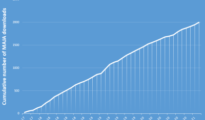
Sentinel-2

Crop Irrigation, a new project labeled by the Space Climate Observatory

=>  The Space Climate Observatory (SCO) is an international initiative of the One Planet Summit, launched in June 2019, which is also a French initiative. The SCO brings together several space agencies around the world and international organizations (UNDP, ESA, UNEP). It aims at developping projects for local decision-makers to help them adapt to climate […]

20.01.2021

Irrigation Grandes Cultures, un nouveau projet labellisé par l’observatoire spatial du climat

=> L‘ Observatoire Spatial du Climat (SCO pour Space Climate Observatory) est une initiative internationale du One Planet Summit, lancée officiellement en Juin 2019, à l’initiative de la France. Cette initiative regroupe des agences spatiales du monde entier et des organisations internationales (PNUD, ESA, PNUE). Elle a pour vocation de développer des projets à destination […]

Free and open data: fine, but who pays for the processing?

In the previous post, Olivier advocated for the open data policy in remote sensing. Although Oliver is facing some actual resistance because the Sentinel-HR mission would step on the toes of industrial champions, my feeling is that there is now a large consensus on this issue. The economic and social benefit of the open data […]

21.12.2020

Free and open data pays off

As for most users of Copernicus or LANDSAT data I guess, the advantages of free and open remote sensing data are so clear that it’s hard to imagine they could be challenged. However, in the framework of Sentinel-HR phase 0, we prepared arguments in case our requirement for free and open data is questioned. Table […]

12.12.2020

Evaluating ERA5 wind direction with Copahue Volcano plume

Copahue is an active volcano in the Andes on the Chile-Argentina border. It erupted in 2016 and a plume of smoke was visible in many Sentinel-2 images during that period. Looking at these pictures I thought it would be fun to use that plume as a giant anemometer to evaluate climate model data. I extracted […]

27.11.2020

Copernicus Land – High-resolution Snow and Ice Monitoring: processing campaign status

  Snow and ice products are now available at high resolution (20×20 m) for all Europe in near-real time. However, Magellium is also processing the Sentinel-2 archive since September 2016. About 70% of Sentinel-2 observations have already been processed and 50 % are already published. This huge computation is being done on the CNES HPC […]

12.11.2020

Stealth snow near Albuquerque, New Mexico

« Give me a hundred tries, I’ll never be able to spell it. » Jimmy McGill I haven’t seen the « Breaking Bad » series but I’m a huge fan of « Better Call Saul ». Both series take place in Albuquerque, New Mexico. With its dry, sunny weather, Albuquerque is the perfect place for a modern-day Western. Vince Gilligan, the […]

08.11.2020

Using PEPS to compute the ground surface displacement after the Palu earthquake

The 7.5 magnitude Palu earthquake in 2018 was a disaster that left 2,081 people dead, 1,309 missing and 206,494 displaced. An impressive surface slip associated with the earthquake was visible in optical satellite imagery like Sentinel-2. I used this case to test the new tool that has been made availabe by the PEPS team (https://peps.cnes.fr/). This tool enables […]

14.10.2020

Sentinel-2 time series resolution should finally reach 10m in November

We have been waiting for a long long time, but it seems the production of geometry refined Sentinel-2 L1C will start by next month. I have heard ESA plans to reproduce the whole data set later on, but the schedule has not been announced yet. « Start of the geometry-refined production using the Global Reference Image […]

13.10.2020

Rechercher