Sentinel-1

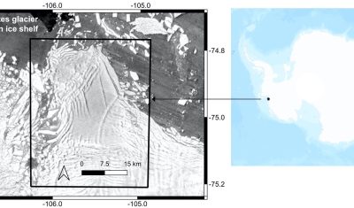
Iceberg B-22A on the go

B-22A is the largest iceberg in the Amundsen Sea, Antarctica (50 times Manhattan land area). It broke off from Thwaites Glacier’s tongue and remained grounded for 20 years.. But now it’s on the go, as shown by this animation I made from Sentinel-1 SAR images (about 1 per month since June 2015, total 75 frames): […]

08.01.2023

Some news from ESA regarding the coming launches of Sentinels 1 and 2

In this article, ESA gave us some news of the time table for the coming launches of next Sentinel1 and 2 satellites. As you may have heard, we have these days a shortage of European launchers, due to the ending of Soyouz launches from Kourou, the delays in Ariane 6 delivery, and the initial uncertainties […]

08.12.2022

First satellite images of Nord Stream leaks

I found the leak from Nord Stream 2 in the latest Sentinel-1 image (29 Sep 2022). It’s large enough to be visible from space. From this radar image, I could also spot the leak in the Landsat image captured on the same day (29 Sep). And there’s another leak visible northeast of Bornholm Island, this […]

29.09.2022

INFERNO: a new software processing radar interferometry time series using Sentinel 1 products

=> The applications of interferometric techniques on radar images are currently developing in many fields. Being able to easily process and plot radar images, interferograms or time series of interferograms with a tool and data that are free and available without being a specialist is an important issue for scientists or companies that do not […]

01.09.2022

TropiSCO scores against deforestation

=> The TropiSCO project aims at providing maps of tree cover loss in dense tropical forests using Sentinel-1 satellite images, starting in 2018 and in near real time. The maps will soon be publicly available via a webGIS platform and updated weekly at 10m resolution. Forest loss as small as 0.1 hectare will be detected […]

05.02.2022

TropiSCO secoue la déforestation

=> L’objectif du projet TropiSCO est de fournir des cartes de suivi des pertes de couverture forestière dans les forêts denses tropicales avec les images des satellites Sentinel-1, à partir de 2018 et en continu. Les cartes seront bientôt accessibles publiquement via une plateforme webGIS et mises à jour toutes les semaines, à 10m de […]

Sentinel-1b is currently out of work

New Update : 1.5 month after, ESA has not yet been able to resume operations with Sentinel-1. The work is now concentrating on understanding the cause of the breakdown, to determine if some modifications are necessary before launching Sentinel1C, not before the end of 2022. Update : 1 week after, attemps to resume exploitation of […]

11.01.2022

La barrière de glace orientale du glacier Thwaites est en train de craquer

Thwaites est un immense glacier en Antarctique qui contribue déjà à 4% de la hausse du niveau des océans à lui tout seul. La barrière de glace flottante devant le front oriental du glacier agit comme un barrage qui ralentit le flux de glace du continent vers l’océan. Si cette plateforme de glace se brise, […]

29.12.2021

MAGicians and deep learning wizards

There are several MAGicians in the CESBIO laboratory, and I am one of them (with all due modesty). According to my definition, MAGicians are participants to Mission Advisory Groups, for instance for CNES or ESA satellite projects. These days, I participate to the MAG for Sentinel-HR at CNES, and for Sentinel-2 Next Generation at ESA. […]

11.11.2021

Rechercher