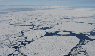
Satellite Missions

SEN2VENμS, a dataset for the training of Sentinel-2 super-resolution algorithms

=>  We are happy to announce the publication of SEN2VENµS, a dataset for the training of Sentinel-2 super-resolution algorithms ! Julien Michel, Juan Vinasco-Salinas, Jordi Inglada, & Olivier Hagolle. (2022). SEN2VENµS, a dataset for the training of Sentinel-2 super-resolution algorithms (1.0.0) [Data set]. Zenodo. https://doi.org/10.5281/zenodo.6514159 A detailed description of the dataset has been published as a […]

17.05.2022

Towards 3D time series

=>  In our a priori definition of Sentinel-HR mission, we had included an option to observe the 3D topography at a high resolution, with a moderate accuracy ambition (lower than that offered by the  CO3D satellite, as shown in the table below), but globally and with a systematic revisit. But our mission advisory group insisted, […]

09.04.2022

Du relief pour nos séries temporelles

 => Dans notre définition initiale de la mission Sentinel-HR, nous avions inclus une option permettant d’observer le relief à haute résolution, avec un objectif de précision modéré (inférieur à celui offert par CO3D, comme le montre le tableau ci-dessous), mais avec une revisite systématique et sur le monde entier. Devant l’intérêt des membres de notre […]

TropiSCO scores against deforestation

=> The TropiSCO project aims at providing maps of tree cover loss in dense tropical forests using Sentinel-1 satellite images, starting in 2018 and in near real time. The maps will soon be publicly available via a webGIS platform and updated weekly at 10m resolution. Forest loss as small as 0.1 hectare will be detected […]

05.02.2022

TropiSCO secoue la déforestation

=> L’objectif du projet TropiSCO est de fournir des cartes de suivi des pertes de couverture forestière dans les forêts denses tropicales avec les images des satellites Sentinel-1, à partir de 2018 et en continu. Les cartes seront bientôt accessibles publiquement via une plateforme webGIS et mises à jour toutes les semaines, à 10m de […]

Sentinel-1b is currently out of work

New Update : 1.5 month after, ESA has not yet been able to resume operations with Sentinel-1. The work is now concentrating on understanding the cause of the breakdown, to determine if some modifications are necessary before launching Sentinel1C, not before the end of 2022. Update : 1 week after, attemps to resume exploitation of […]

11.01.2022

CO3D: CNES Very High Resolution mission dedicated to 3D, to produce a global DSM by 2027

  Do you know the CNES/AIRBUS CO3D mission ? As our Sentinel-HR mission could be made of satellites derived from those of the CO3D mission, it is a good opportunity to advertise this nice mission here. I took all the information from a presentation and a paper [1] written by Laurent Lebègue and the CO3D […]

09.01.2022

La barrière de glace orientale du glacier Thwaites est en train de craquer

Thwaites est un immense glacier en Antarctique qui contribue déjà à 4% de la hausse du niveau des océans à lui tout seul. La barrière de glace flottante devant le front oriental du glacier agit comme un barrage qui ralentit le flux de glace du continent vers l’océan. Si cette plateforme de glace se brise, […]

29.12.2021

Viedma glacier terminus since 1985

Viedma Glacier is an iconic glacier of the Southern Patagonia icefield. Landsat 5, Landsat 8 and Sentinel-2 images series show that its terminus has retreated by 3 km since 1985. Looking closer one can notice a new proglacial lake forming in a recently deglaciated area. Since I won 80 sq km of Airbus Pléiades data, […]

27.12.2021

Rechercher